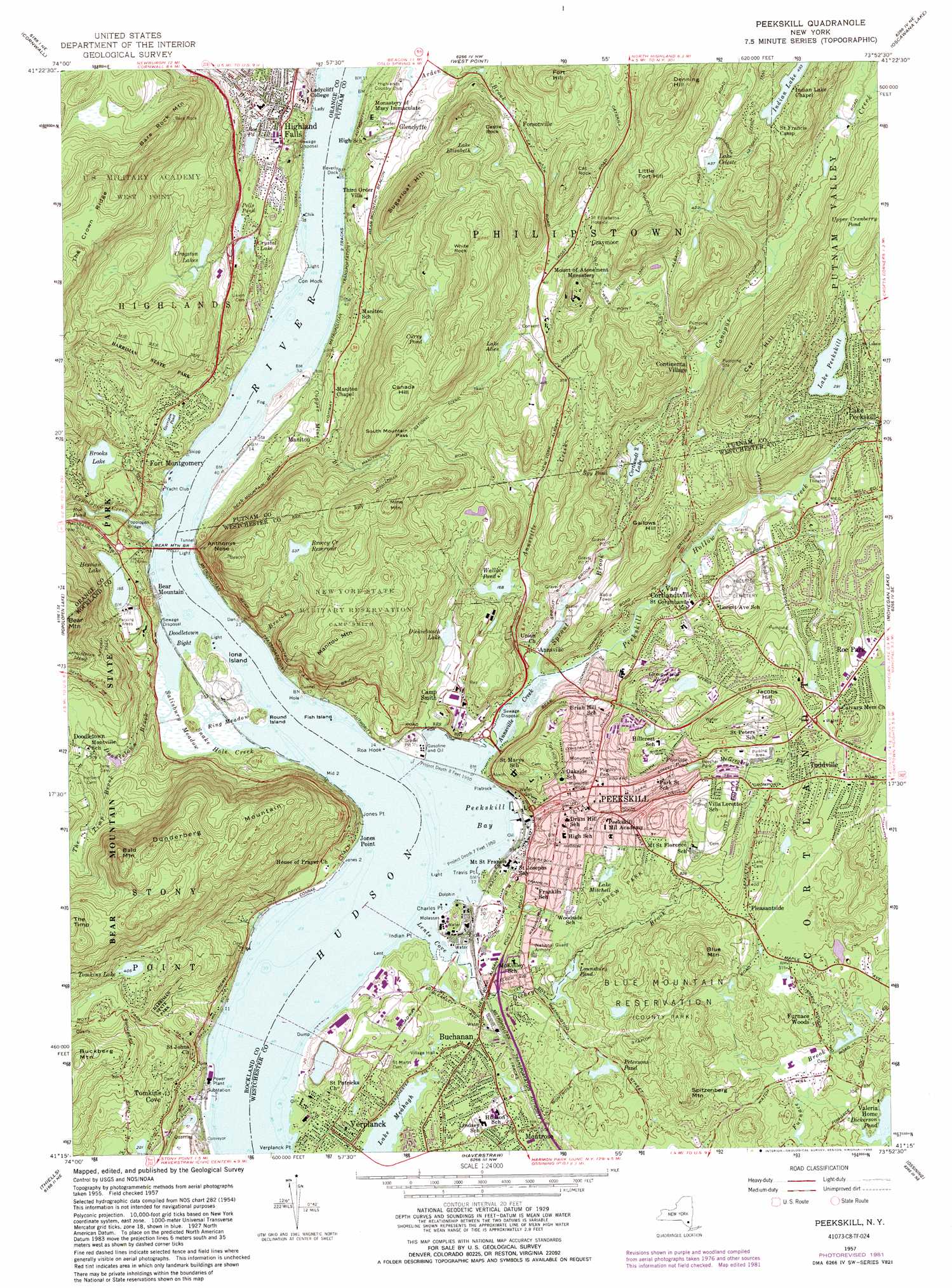
Peekskill Topo Map New York
To zoom in, hover over the map of Peekskill
USGS Topo Quad 41073c8 - 1:24,000 scale
| Topo Map Name: | Peekskill |
| USGS Topo Quad ID: | 41073c8 |
| Print Size: | ca. 21 1/4" wide x 27" high |
| Southeast Coordinates: | 41.25° N latitude / 73.875° W longitude |
| Map Center Coordinates: | 41.3125° N latitude / 73.9375° W longitude |
| U.S. State: | NY |
| Filename: | o41073c8.jpg |
| Download Map JPG Image: | Peekskill topo map 1:24,000 scale |
| Map Type: | Topographic |
| Topo Series: | 7.5´ |
| Map Scale: | 1:24,000 |
| Source of Map Images: | United States Geological Survey (USGS) |
| Alternate Map Versions: |
Peekskill NY 1947 Download PDF Buy paper map Peekskill NY 1957, updated 1959 Download PDF Buy paper map Peekskill NY 1957, updated 1964 Download PDF Buy paper map Peekskill NY 1957, updated 1981 Download PDF Buy paper map Peekskill NY 1957, updated 1990 Download PDF Buy paper map Peekskill NY 1957, updated 1990 Download PDF Buy paper map Peekskill NY 1957, updated 1990 Download PDF Buy paper map Peekskill NY 2010 Download PDF Buy paper map Peekskill NY 2013 Download PDF Buy paper map Peekskill NY 2016 Download PDF Buy paper map |
1:24,000 Topo Quads surrounding Peekskill
Walden |
Newburgh |
Wappingers Falls |
Hopewell Junction |
Poughquag |
Maybrook |
Cornwall |
West Point |
Oscawana Lake |
Lake Carmel |
Monroe |
Popolopen Lake |
Peekskill |
Mohegan Lake |
Croton Falls |
Sloatsburg |
Thiells |
Haverstraw |
Ossining |
Mount Kisco |
Ramsey |
Park Ridge |
Nyack |
White Plains |
Glenville |
> Back to 41073a1 at 1:100,000 scale
> Back to 41072a1 at 1:250,000 scale
> Back to U.S. Topo Maps home
Peekskill topo map: Gazetteer
Peekskill: Airports
Westchester Resco Heliport elevation 17m 55′Peekskill: Bays
Doodletown Bight elevation 0m 0′Lents Cove elevation -1m -4′
Peekskill Bay elevation 0m 0′
Sandy Cove elevation 1m 3′
Peekskill: Bridges
Bear Mountain Bridge elevation 0m 0′Cortlandt Bridge elevation 3m 9′
Popolopen Bridge elevation 2m 6′
Peekskill: Canals
Catskill Aqueduct elevation 202m 662′Peekskill: Capes
Charles Point elevation 4m 13′Con Hook elevation 5m 16′
East Gable elevation 4m 13′
Flat Point elevation 2m 6′
Indian Point elevation 4m 13′
Jones Point elevation 6m 19′
Mystery Point elevation 13m 42′
Roa Hook elevation 5m 16′
Travis Point elevation 7m 22′
Peekskill: Channels
The Race elevation 0m 0′Peekskill: Cliffs
Anthonys Nose elevation 140m 459′Peekskill: Falls
Buttermilk Falls elevation 16m 52′Peekskill: Flats
Marys Meadow elevation 66m 216′Ring Meadow elevation 3m 9′
Salisbury Meadow elevation 3m 9′
Peekskill: Gaps
South Mountain Pass elevation 161m 528′Peekskill: Islands
Fish Island elevation 0m 0′Iona Island elevation 18m 59′
Livingston Island elevation 15m 49′
Round Island elevation 18m 59′
Peekskill: Lakes
Brooks Lake elevation 37m 121′Crystal Lake elevation 48m 157′
Curry Pond elevation 198m 649′
Dickiebusch Lake elevation 27m 88′
Garrison Pond elevation 41m 134′
Hessian Lake elevation 47m 154′
Indian Lake elevation 150m 492′
Lake Alice elevation 125m 410′
Lake Celeste elevation 133m 436′
Lake Elizabeth elevation 179m 587′
Lake Meahagh elevation 3m 9′
Lake Mitchell elevation 76m 249′
Lake Peekskill elevation 88m 288′
Lounsbury Pond elevation 27m 88′
Nelson Pond elevation 88m 288′
Pells Pond elevation 54m 177′
Penelope Pond elevation 72m 236′
Spy Pond elevation 35m 114′
Tomkins Lake elevation 123m 403′
Upper Cranberry Pond elevation 161m 528′
Peekskill: Parks
Bear Mountain State Park elevation 111m 364′Bear Mountain State Park elevation 86m 282′
Blue Mountain Reservation elevation 123m 403′
Depew Park elevation 82m 269′
Fort Hill Park elevation 105m 344′
Friendly Town Memorial Park elevation 25m 82′
Furnace Brook Headwater Preserve elevation 94m 308′
Henry Ward Beecher Park elevation 72m 236′
Indian Point Park (historical) elevation 10m 32′
Iona Island Component Hudson River National Estuarine Research Reserve elevation 3m 9′
Lents Cove Park elevation 12m 39′
Monument Park elevation 54m 177′
Pugsley Park elevation 46m 150′
Riverfront Green elevation 3m 9′
Roe Park elevation 63m 206′
Wells Park elevation 75m 246′
Peekskill: Populated Places
Annsville elevation 4m 13′Buchanan elevation 12m 39′
Buckberg elevation 174m 570′
Continental Village elevation 52m 170′
Finktown elevation 82m 269′
Forsonville elevation 119m 390′
Fort Clinton elevation 32m 104′
Fort Montgomery elevation 49m 160′
Furnace Woods elevation 97m 318′
Gallows Hill elevation 131m 429′
Glenclyffe elevation 41m 134′
Graymoor elevation 156m 511′
Highland Falls elevation 44m 144′
Hudson View Terrace Mobile Home Park elevation 39m 127′
Jones Point elevation 7m 22′
Lake Peekskill elevation 96m 314′
Manitou elevation 37m 121′
Montrose elevation 35m 114′
Peekskill elevation 39m 127′
Pleasantside elevation 119m 390′
Roe Park elevation 113m 370′
Toddville elevation 101m 331′
Tomkins Cove elevation 44m 144′
Van Cortlandtville elevation 25m 82′
Verplanck elevation 18m 59′
Westpoint Mobile Home Park elevation 34m 111′
Peekskill: Post Offices
Fort Montgomery Post Office elevation 50m 164′Peekskill Post Office elevation 39m 127′
Peekskill: Reservoirs
Broccy Creek Reservoir elevation 162m 531′Camp Field Reservoir elevation 112m 367′
Cortlandt Lake elevation 26m 85′
Cragston Lakes elevation 94m 308′
Dickerson Pond elevation 86m 282′
Locust Avenue Lake elevation 112m 367′
Petersons Pond elevation 45m 147′
Quarry Pond elevation 68m 223′
Roe Pond elevation 61m 200′
Roe Pond elevation 15m 49′
Wallace Pond elevation 49m 160′
Peekskill: Ridges
The Crown Ridge elevation 290m 951′Peekskill: Streams
Annsville Creek elevation 0m 0′Broccy Creek elevation 1m 3′
Canopus Creek elevation 28m 91′
Copper Mine Brook elevation 1m 3′
Dickey Brook elevation 3m 9′
Doodletown Brook elevation 1m 3′
Highland Brook elevation 4m 13′
McGregory Brook elevation 70m 229′
Peekskill Hollow Creek elevation 3m 9′
Popolopen Creek elevation 0m 0′
Snake Hole Creek elevation 0m 0′
Sprout Brook elevation 3m 9′
The Timp Brook elevation 66m 216′
Peekskill: Summits
Academy Hill elevation 76m 249′Bald Mountain elevation 341m 1118′
Bare Rock Mountain elevation 373m 1223′
Blue Mountain elevation 202m 662′
Canada Hill elevation 257m 843′
Castle Rock elevation 191m 626′
Cat Hill elevation 225m 738′
Cat Rock elevation 224m 734′
Creek Hill elevation 66m 216′
Denning Hill elevation 309m 1013′
Drum Hill elevation 62m 203′
Dunderberg Mountain elevation 325m 1066′
Emery Hill elevation 195m 639′
Fort Hill elevation 248m 813′
Fort Hill elevation 114m 374′
Hall Hill elevation 67m 219′
Jacobs Hill elevation 184m 603′
Little Fort Hill elevation 244m 800′
Manitou Mountain elevation 236m 774′
Mine Mountain elevation 262m 859′
Saint Gabriels Hill elevation 100m 328′
Spitzenberg Mountain elevation 166m 544′
Sugarloaf Hill elevation 225m 738′
The Timp elevation 300m 984′
Washington Hill elevation 43m 141′
White Rock elevation 225m 738′
Peekskill digital topo map on disk
Buy this Peekskill topo map showing relief, roads, GPS coordinates and other geographical features, as a high-resolution digital map file on DVD:
New York, Vermont, Connecticut & Western Massachusetts
Buy digital topo maps: New York, Vermont, Connecticut & Western Massachusetts