Danbury Topo Map Connecticut
To zoom in, hover over the map of Danbury
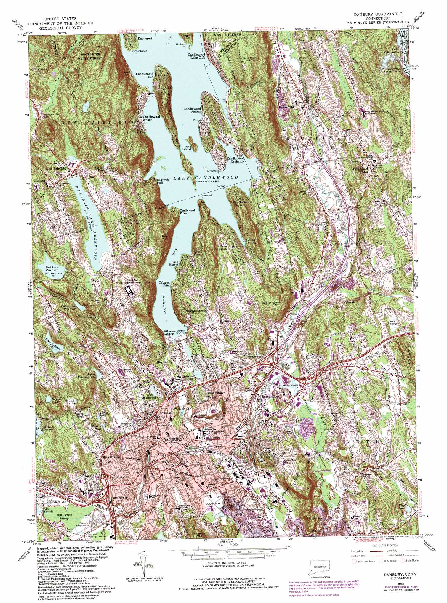
USGS Topo Quad 41073d4 - 1:24,000 scale
| Topo Map Name: | Danbury |
| USGS Topo Quad ID: | 41073d4 |
| Print Size: | ca. 21 1/4" wide x 27" high |
| Southeast Coordinates: | 41.375° N latitude / 73.375° W longitude |
| Map Center Coordinates: | 41.4375° N latitude / 73.4375° W longitude |
| U.S. State: | CT |
| Filename: | o41073d4.jpg |
| Download Map JPG Image: | Danbury topo map 1:24,000 scale |
| Map Type: | Topographic |
| Topo Series: | 7.5´ |
| Map Scale: | 1:24,000 |
| Source of Map Images: | United States Geological Survey (USGS) |
| Alternate Map Versions: |
Danbury CT 1953, updated 1959 Download PDF Buy paper map Danbury CT 1963, updated 1965 Download PDF Buy paper map Danbury CT 1963, updated 1974 Download PDF Buy paper map Danbury CT 1963, updated 1984 Download PDF Buy paper map Danbury CT 1963, updated 1984 Download PDF Buy paper map Danbury CT 2012 Download PDF Buy paper map Danbury CT 2015 Download PDF Buy paper map |
1:24,000 Topo Quads surrounding Danbury
Verbank |
Dover Plains |
Kent |
New Preston |
Litchfield |
Poughquag |
Pawling |
New Milford |
Roxbury |
Woodbury |
Lake Carmel |
Brewster |
Danbury |
Newtown |
Southbury |
Croton Falls |
Peach Lake |
Bethel |
Botsford |
Long Hill |
Mount Kisco |
Pound Ridge |
Norwalk North |
Westport |
Bridgeport |
> Back to 41073a1 at 1:100,000 scale
> Back to 41072a1 at 1:250,000 scale
> Back to U.S. Topo Maps home
Danbury topo map: Gazetteer
Danbury: Airports
BIP Heliport elevation 136m 446′Danbury Hospital Heliport elevation 148m 485′
Danbury: Bays
Danbury Bay elevation 131m 429′Lower Pine Cove elevation 131m 429′
Danbury: Bridges
Barn Plain Bridge elevation 109m 357′Old Grays Bridge elevation 86m 282′
Sherman Bridge elevation 87m 285′
Danbury: Capes
Arrowhead Point elevation 134m 439′Chatterton Point elevation 132m 433′
Driftwood Point elevation 134m 439′
Never Sink Point elevation 139m 456′
Orchard Point elevation 134m 439′
Pocono Point elevation 131m 429′
Danbury: Crossings
Interchange 3 elevation 142m 465′Interchange 4 elevation 154m 505′
Interchange 5 elevation 128m 419′
Interchange 7 elevation 89m 291′
Interchange 8 elevation 102m 334′
Danbury: Dams
East Lake Reservoir Dam elevation 207m 679′Forest Lake Dam elevation 232m 761′
Lake Candlewood Dike elevation 130m 426′
Lower Kohanza Dam elevation 177m 580′
Mercers Pond Dam elevation 155m 508′
Padanaram Reservoir Dam elevation 176m 577′
Upper Kohanza Dam elevation 222m 728′
West Lake Reservoir Dam elevation 191m 626′
Danbury: Islands
Candlewood Isle elevation 198m 649′Pine Island elevation 144m 472′
Danbury: Lakes
Dickens Pond elevation 215m 705′Disbrow Pond elevation 160m 524′
Doyles Pond elevation 136m 446′
Kellners Pond elevation 144m 472′
Lake Wackawana elevation 155m 508′
Mercers Pond elevation 155m 508′
Rogers Pond elevation 165m 541′
Turtle Pond elevation 153m 501′
Danbury: Parks
Bear Mountain Reservation elevation 266m 872′Danbury Town Park elevation 127m 416′
Hatters Park elevation 135m 442′
Lions Park elevation 127m 416′
Main Street Historic District elevation 120m 393′
Main Street Park elevation 120m 393′
Meckauer Park elevation 93m 305′
Rogers Park elevation 116m 380′
Town Park elevation 133m 436′
Williams Park elevation 135m 442′
Danbury: Populated Places
Aqua Vista elevation 177m 580′Beaverbrook elevation 94m 308′
Beckettville elevation 175m 574′
Brookfield elevation 90m 295′
Brookfield Center elevation 152m 498′
Candlewood Knolls elevation 142m 465′
Candlewood Lake Club elevation 149m 488′
Candlewood Orchards elevation 148m 485′
Candlewood Pines elevation 137m 449′
Candlewood Shores elevation 151m 495′
Cedar Heights elevation 150m 492′
Danbury elevation 121m 396′
Germantown elevation 159m 521′
Hawthorne Terrace elevation 156m 511′
Hayestown elevation 139m 456′
Hollywyle Park elevation 145m 475′
Knollcrest elevation 148m 485′
Lattins Landing elevation 144m 472′
Margerie Manor elevation 255m 836′
New Fairfield elevation 182m 597′
Pleasant Acres elevation 153m 501′
Snug Harbor elevation 136m 446′
Ta'agan Point elevation 138m 452′
Wildmans Landing elevation 131m 429′
Danbury: Post Offices
Brookfield Center Post Office elevation 169m 554′Danbury Post Office elevation 118m 387′
New Fairfield Post Office elevation 153m 501′
Danbury: Reservoirs
East Lake Reservoir elevation 207m 679′Forest Lake elevation 232m 761′
King Lake elevation 133m 436′
Lower Kohanza Lake elevation 177m 580′
Old Mill Pond (historical) elevation 138m 452′
Padanaram Reservoir elevation 176m 577′
Rogers Park Pond elevation 112m 367′
Upper Kohanza Lake elevation 222m 728′
West Lake Reservoir elevation 191m 626′
Danbury: Ridges
Candleview Ridge elevation 156m 511′Danbury: Streams
Ball Pond Brook elevation 135m 442′Bates Brook elevation 165m 541′
Dibbles Brook elevation 124m 406′
East Brook elevation 78m 255′
East Lake Brook elevation 178m 583′
East Swamp Brook elevation 90m 295′
Hop Brook elevation 61m 200′
Kissen Brook elevation 138m 452′
Kohanza Brook elevation 116m 380′
Lees Pond Brook elevation 139m 456′
Limekiln Brook elevation 91m 298′
Limekiln Brook elevation 70m 229′
Mann Brook elevation 139m 456′
Merwin Brook elevation 67m 219′
Miry Brook elevation 129m 423′
Padanaram Brook elevation 116m 380′
Parks Pond Brook elevation 132m 433′
Short Woods Brook elevation 182m 597′
Stony Hill Brook elevation 87m 285′
Sympaug Brook elevation 108m 354′
West Brook elevation 82m 269′
Wolf Pit Brook elevation 117m 383′
Danbury: Summits
Bear Mountain elevation 261m 856′Beaver Brook Mountain elevation 179m 587′
Deer Hill elevation 147m 482′
Huckleberry Hill elevation 186m 610′
Mountain End elevation 201m 659′
Shelter Rock elevation 194m 636′
Stony Hill elevation 154m 505′
Sweet Cake Mountain elevation 265m 869′
Town Hill elevation 130m 426′
Danbury: Swamps
Bound Swamp elevation 126m 413′East Swamp elevation 122m 400′
Mill Plain Swamp elevation 136m 446′
Danbury digital topo map on disk
Buy this Danbury topo map showing relief, roads, GPS coordinates and other geographical features, as a high-resolution digital map file on DVD:
New York, Vermont, Connecticut & Western Massachusetts
Buy digital topo maps: New York, Vermont, Connecticut & Western Massachusetts