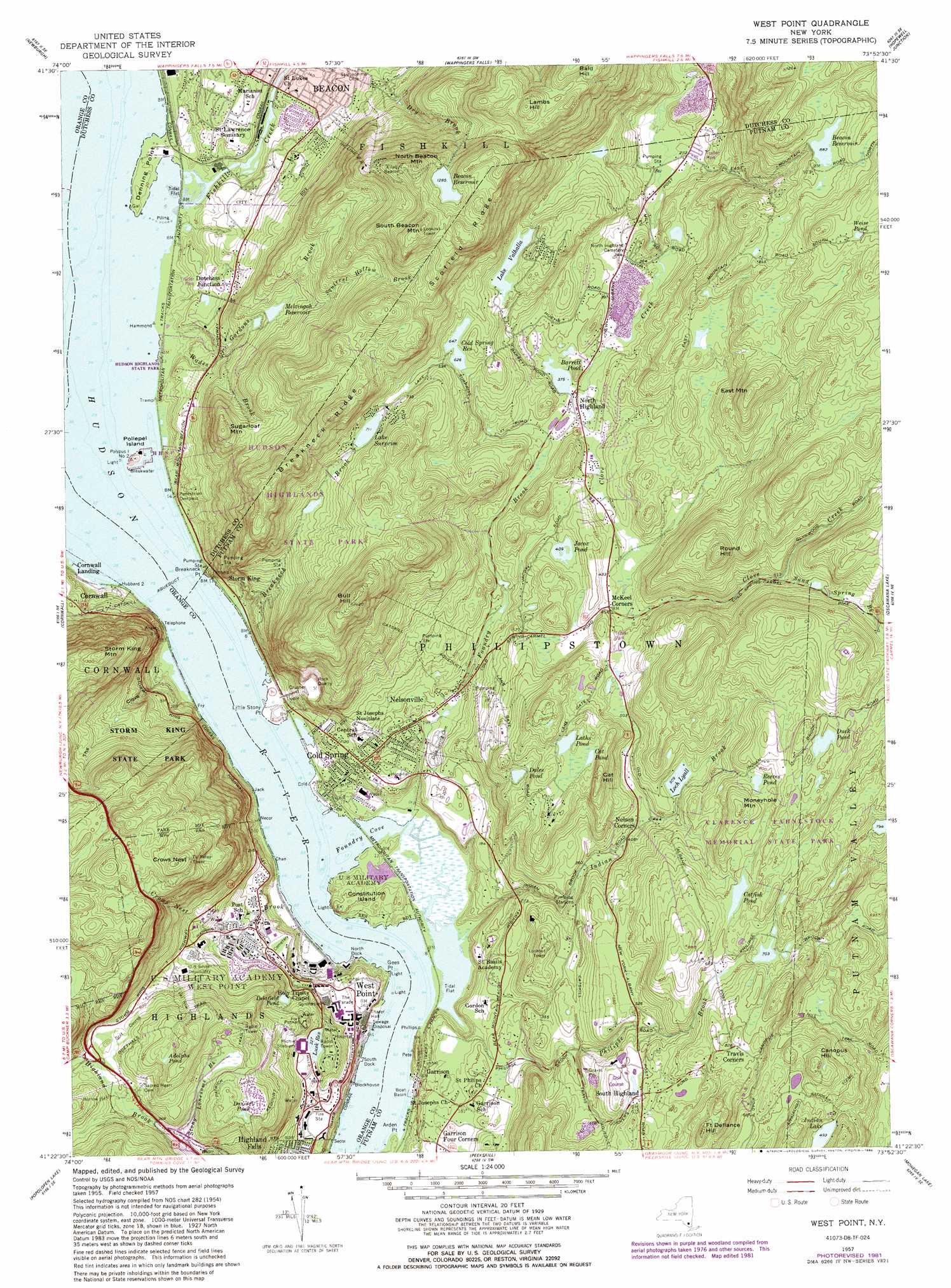
West Point Topo Map New York
To zoom in, hover over the map of West Point
USGS Topo Quad 41073d8 - 1:24,000 scale
| Topo Map Name: | West Point |
| USGS Topo Quad ID: | 41073d8 |
| Print Size: | ca. 21 1/4" wide x 27" high |
| Southeast Coordinates: | 41.375° N latitude / 73.875° W longitude |
| Map Center Coordinates: | 41.4375° N latitude / 73.9375° W longitude |
| U.S. State: | NY |
| Filename: | o41073d8.jpg |
| Download Map JPG Image: | West Point topo map 1:24,000 scale |
| Map Type: | Topographic |
| Topo Series: | 7.5´ |
| Map Scale: | 1:24,000 |
| Source of Map Images: | United States Geological Survey (USGS) |
| Alternate Map Versions: |
West Point NY 1941, updated 1951 Download PDF Buy paper map West Point NY 1947 Download PDF Buy paper map West Point NY 1957, updated 1965 Download PDF Buy paper map West Point NY 1957, updated 1973 Download PDF Buy paper map West Point NY 1957, updated 1981 Download PDF Buy paper map West Point NY 1957, updated 1988 Download PDF Buy paper map West Point NY 2010 Download PDF Buy paper map West Point NY 2013 Download PDF Buy paper map West Point NY 2016 Download PDF Buy paper map |
1:24,000 Topo Quads surrounding West Point
Gardiner |
Clintondale |
Poughkeepsie |
Pleasant Valley |
Verbank |
Walden |
Newburgh |
Wappingers Falls |
Hopewell Junction |
Poughquag |
Maybrook |
Cornwall |
West Point |
Oscawana Lake |
Lake Carmel |
Monroe |
Popolopen Lake |
Peekskill |
Mohegan Lake |
Croton Falls |
Sloatsburg |
Thiells |
Haverstraw |
Ossining |
Mount Kisco |
> Back to 41073a1 at 1:100,000 scale
> Back to 41072a1 at 1:250,000 scale
> Back to U.S. Topo Maps home
West Point topo map: Gazetteer
West Point: Basins
Worlds End elevation 0m 0′West Point: Bays
Foundry Cove elevation 1m 3′West Point: Bridges
Tioronda Bridge (historical) elevation 0m 0′West Point: Capes
Arden Point elevation 7m 22′Breakneck Point elevation 24m 78′
Denning Point elevation 6m 19′
Gees Point elevation 6m 19′
Little Stony Point elevation 17m 55′
Magazine Point elevation 20m 65′
Target Point elevation 3m 9′
Valley Point elevation 29m 95′
West Point: Channels
Martyrs Reach elevation 0m 0′West Point: Islands
Constitution Island elevation 10m 32′Duck Island elevation 0m 0′
Pollepel Island elevation 18m 59′
West Point: Lakes
Adolphs Pond elevation 259m 849′Barrett Pond elevation 114m 374′
Cat Pond elevation 194m 636′
Catfish Pond elevation 216m 708′
Dales Pond elevation 155m 508′
Dassori Pond elevation 213m 698′
Duck Pond elevation 271m 889′
Jacox Pond elevation 124m 406′
Lake Valhalla elevation 185m 606′
Laths Pond elevation 194m 636′
Reeves Pond elevation 228m 748′
Weise Pond elevation 327m 1072′
West Point: Parks
Buffalo Soldiers Field elevation 46m 150′Clinton Field elevation 52m 170′
Cold Spring Historic District elevation 22m 72′
Constitution Marsh Audubon Center And Sanctuary elevation 4m 13′
Daly Field elevation 51m 167′
Doubleday Field elevation 49m 160′
Howze Field elevation 101m 331′
Hudson Highlands State Park elevation 225m 738′
Kosciuszko Monument elevation 46m 150′
Michie Stadium elevation 102m 334′
North Athletic Field elevation 5m 16′
Sedgwick Monument elevation 46m 150′
Target Hill Athletic Field elevation 5m 16′
The Parade elevation 47m 154′
Wood Monument elevation 43m 141′
West Point: Populated Places
Brookside Senior Citizen Cooperative elevation 85m 278′Cold Spring elevation 35m 114′
Cold Spring Mobile Home Park elevation 104m 341′
Dutchess Junction elevation 27m 88′
Garrison elevation 16m 52′
Nelson Corners elevation 127m 416′
Nelsonville elevation 57m 187′
North Dock elevation 0m 0′
North Highland elevation 127m 416′
South Highland elevation 184m 603′
West Point elevation 47m 154′
West Point: Reservoirs
Barett Pond elevation 188m 616′Beacon Reservoir elevation 268m 879′
Beacon Reservoir elevation 389m 1276′
Cold Spring Reservoir elevation 191m 626′
Delafield Pond elevation 86m 282′
Lake Surprise elevation 216m 708′
Loch Lyall elevation 155m 508′
Lusk Reservoir elevation 99m 324′
Melzingah Reservoir elevation 125m 410′
West Point: Ridges
Breakneck Ridge elevation 339m 1112′Scofield Ridge elevation 466m 1528′
West Point: Streams
Arden Brook elevation 4m 13′Breakneck Brook elevation 3m 9′
Crows Nest Brook elevation 1m 3′
Fishkill Creek elevation 3m 9′
Foundry Brook elevation 0m 0′
Gordons Brook elevation 3m 9′
Indian Brook elevation 3m 9′
Philips Brook elevation 12m 39′
Squirrel Hollow Brook elevation 135m 442′
Stony Lonesome Brook elevation 149m 488′
Wades Brook elevation 0m 0′
West Point: Summits
Bull Hill elevation 430m 1410′Canopus Hill elevation 252m 826′
Cat Hill elevation 255m 836′
Crows Nest elevation 429m 1407′
East Mountain elevation 326m 1069′
Fort Defiance Hill elevation 304m 997′
Lambs Hill elevation 454m 1489′
Moneyhole Mountain elevation 281m 921′
North Beacon Mountain elevation 465m 1525′
Round Hill elevation 330m 1082′
South Beacon Mountain elevation 491m 1610′
Storm King Mountain elevation 411m 1348′
Sugarloaf Mountain elevation 275m 902′
West Point: Swamps
Constitution Island Marsh elevation 3m 9′West Point: Trails
Goethals Trail elevation 252m 826′Patrick Trail elevation 228m 748′
Pipe Line Trail elevation 96m 314′
Redoubt Trail elevation 163m 534′
West Point: Valleys
The Clove elevation 3m 9′West Point digital topo map on disk
Buy this West Point topo map showing relief, roads, GPS coordinates and other geographical features, as a high-resolution digital map file on DVD:
New York, Vermont, Connecticut & Western Massachusetts
Buy digital topo maps: New York, Vermont, Connecticut & Western Massachusetts