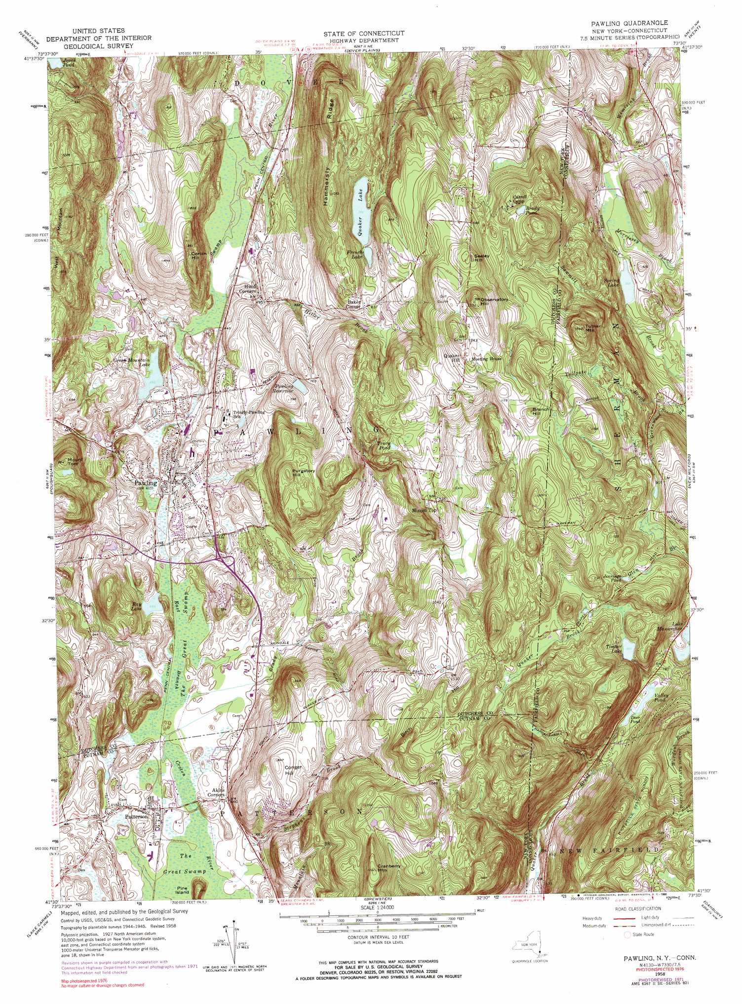
Pawling Topo Map New York
To zoom in, hover over the map of Pawling
USGS Topo Quad 41073e5 - 1:24,000 scale
| Topo Map Name: | Pawling |
| USGS Topo Quad ID: | 41073e5 |
| Print Size: | ca. 21 1/4" wide x 27" high |
| Southeast Coordinates: | 41.5° N latitude / 73.5° W longitude |
| Map Center Coordinates: | 41.5625° N latitude / 73.5625° W longitude |
| U.S. States: | NY, CT |
| Filename: | o41073e5.jpg |
| Download Map JPG Image: | Pawling topo map 1:24,000 scale |
| Map Type: | Topographic |
| Topo Series: | 7.5´ |
| Map Scale: | 1:24,000 |
| Source of Map Images: | United States Geological Survey (USGS) |
| Alternate Map Versions: |
Pawling NY 1945, updated 1956 Download PDF Buy paper map Pawling NY 1958, updated 1960 Download PDF Buy paper map Pawling NY 1958, updated 1964 Download PDF Buy paper map Pawling NY 1958, updated 1972 Download PDF Buy paper map Pawling NY 1958, updated 1990 Download PDF Buy paper map Pawling NY 1998, updated 2000 Download PDF Buy paper map Pawling NY 2010 Download PDF Buy paper map Pawling NY 2013 Download PDF Buy paper map Pawling NY 2016 Download PDF Buy paper map |
1:24,000 Topo Quads surrounding Pawling
Salt Point |
Millbrook |
Amenia |
Ellsworth |
Cornwall |
Pleasant Valley |
Verbank |
Dover Plains |
Kent |
New Preston |
Hopewell Junction |
Poughquag |
Pawling |
New Milford |
Roxbury |
Oscawana Lake |
Lake Carmel |
Brewster |
Danbury |
Newtown |
Mohegan Lake |
Croton Falls |
Peach Lake |
Bethel |
Botsford |
> Back to 41073e1 at 1:100,000 scale
> Back to 41072a1 at 1:250,000 scale
> Back to U.S. Topo Maps home
Pawling topo map: Gazetteer
Pawling: Dams
Spring Lake Dam elevation 169m 554′Timber Lake Dam elevation 274m 898′
Pawling: Islands
Pine Island elevation 178m 583′Pawling: Lakes
Brady Pond elevation 323m 1059′Deer Pond elevation 218m 715′
French Lake elevation 238m 780′
Green Mountain Lake elevation 142m 465′
Jennings Pond elevation 300m 984′
Jones Pond elevation 288m 944′
Quaker Lake elevation 238m 780′
Ray Lake elevation 138m 452′
Spring Lake elevation 169m 554′
Timber Lake elevation 274m 898′
Tracy Pond elevation 296m 971′
Valley Pond elevation 220m 721′
Pawling: Parks
Edward R Murrow Park elevation 149m 488′Pawling: Populated Places
Baker Corner elevation 257m 843′Hurd Corners elevation 146m 479′
Patterson elevation 135m 442′
Pawling elevation 141m 462′
Quaker Hill elevation 369m 1210′
Pawling: Reservoirs
Pawling Reservoir elevation 207m 679′Timber Lake elevation 274m 898′
Pawling: Ridges
Hammersly Ridge elevation 306m 1003′Pawling: Streams
Brady Brook elevation 133m 436′Greenwood Brook elevation 159m 521′
Hiller Brook elevation 130m 426′
Quaker Brook elevation 153m 501′
Stephens Brook elevation 130m 426′
Pawling: Summits
Birch Hill elevation 386m 1266′Branch Hill elevation 370m 1213′
Conger Hill elevation 257m 843′
Corbin Hill elevation 256m 839′
Cranberry Mountain elevation 376m 1233′
Mizzen Top elevation 296m 971′
Mount Tom elevation 294m 964′
Observatory Hill elevation 405m 1328′
Purgatory Hill elevation 308m 1010′
Seeley Hill elevation 368m 1207′
Turner Mountain elevation 362m 1187′
West Mountain elevation 360m 1181′
Pawling: Swamps
The Great Swamp elevation 133m 436′Pawling digital topo map on disk
Buy this Pawling topo map showing relief, roads, GPS coordinates and other geographical features, as a high-resolution digital map file on DVD:
New York, Vermont, Connecticut & Western Massachusetts
Buy digital topo maps: New York, Vermont, Connecticut & Western Massachusetts