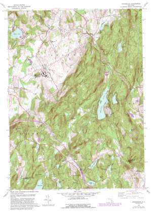
Poughquag Topo Map New York
To zoom in, hover over the map of Poughquag
USGS Topo Quad 41073e6 - 1:24,000 scale
| Topo Map Name: | Poughquag |
| USGS Topo Quad ID: | 41073e6 |
| Print Size: | ca. 21 1/4" wide x 27" high |
| Southeast Coordinates: | 41.5° N latitude / 73.625° W longitude |
| Map Center Coordinates: | 41.5625° N latitude / 73.6875° W longitude |
| U.S. State: | NY |
| Filename: | o41073e6.jpg |
| Download Map JPG Image: | Poughquag topo map 1:24,000 scale |
| Map Type: | Topographic |
| Topo Series: | 7.5´ |
| Map Scale: | 1:24,000 |
| Source of Map Images: | United States Geological Survey (USGS) |
| Alternate Map Versions: |
Poughquag NY 1948 Download PDF Buy paper map Poughquag NY 1948 Download PDF Buy paper map Poughquag NY 1960, updated 1961 Download PDF Buy paper map Poughquag NY 1960, updated 1967 Download PDF Buy paper map Poughquag NY 1960, updated 1982 Download PDF Buy paper map Poughquag NY 1960, updated 1988 Download PDF Buy paper map Poughquag NY 2010 Download PDF Buy paper map Poughquag NY 2013 Download PDF Buy paper map Poughquag NY 2016 Download PDF Buy paper map |
1:24,000 Topo Quads surrounding Poughquag
> Back to 41073e1 at 1:100,000 scale
> Back to 41072a1 at 1:250,000 scale
> Back to U.S. Topo Maps home
Poughquag topo map: Gazetteer
Poughquag: Airports
Stormville Airport elevation 105m 344′Poughquag: Lakes
Mill Pond elevation 226m 741′Parce Pond elevation 205m 672′
Sylvan Lake elevation 98m 321′
Whaley Lake elevation 215m 705′
White Pond elevation 252m 826′
Poughquag: Populated Places
Beekman elevation 115m 377′Green Haven elevation 116m 380′
Harmony Park elevation 145m 475′
Holmes elevation 211m 692′
Ludingtonville elevation 276m 905′
Pecksville elevation 246m 807′
Pine Grove Terrace elevation 145m 475′
Poughquag elevation 133m 436′
Stormville elevation 100m 328′
Sylvan Lake elevation 106m 347′
West Patterson elevation 166m 544′
West Pawling elevation 212m 695′
Woodinville elevation 201m 659′
Poughquag: Reservoirs
Ballard Lake elevation 276m 905′Ballard Pond elevation 326m 1069′
Browns Pond elevation 213m 698′
Denton Lake elevation 227m 744′
Harmony Lake elevation 229m 751′
Lake Dutchess elevation 222m 728′
Little Whaley Lake elevation 280m 918′
Nuclear Lake elevation 231m 757′
South Lake elevation 240m 787′
Stump Pond elevation 209m 685′
Sunset Lake elevation 259m 849′
Westminster Lake elevation 248m 813′
Willow Lake elevation 241m 790′
Poughquag: Streams
Flat Rock Brook elevation 131m 429′Frog Hollow Brook elevation 94m 308′
Gardner Hollow Brook elevation 139m 456′
Leetown Brook elevation 198m 649′
Whaley Lake Stream elevation 105m 344′
Poughquag: Summits
Depot Hill elevation 398m 1305′Miller Hill elevation 303m 994′
Money Ledge Hill elevation 338m 1108′
Pawling Mountain elevation 345m 1131′
Stormville Mountain elevation 321m 1053′
Poughquag: Swamps
Bear Swamp elevation 246m 807′Poughquag: Valleys
Grape Hollow elevation 248m 813′Poughquag digital topo map on disk
Buy this Poughquag topo map showing relief, roads, GPS coordinates and other geographical features, as a high-resolution digital map file on DVD:
New York, Vermont, Connecticut & Western Massachusetts
Buy digital topo maps: New York, Vermont, Connecticut & Western Massachusetts


