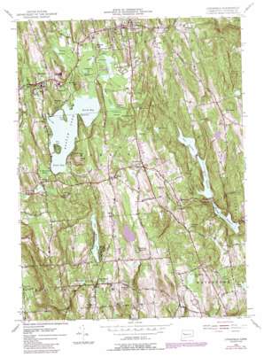
Litchfield Topo Map Connecticut
To zoom in, hover over the map of Litchfield
USGS Topo Quad 41073f2 - 1:24,000 scale
| Topo Map Name: | Litchfield |
| USGS Topo Quad ID: | 41073f2 |
| Print Size: | ca. 21 1/4" wide x 27" high |
| Southeast Coordinates: | 41.625° N latitude / 73.125° W longitude |
| Map Center Coordinates: | 41.6875° N latitude / 73.1875° W longitude |
| U.S. State: | CT |
| Filename: | o41073f2.jpg |
| Download Map JPG Image: | Litchfield topo map 1:24,000 scale |
| Map Type: | Topographic |
| Topo Series: | 7.5´ |
| Map Scale: | 1:24,000 |
| Source of Map Images: | United States Geological Survey (USGS) |
| Alternate Map Versions: |
Litchfield CT 1956, updated 1958 Download PDF Buy paper map Litchfield CT 1956, updated 1958 Download PDF Buy paper map Litchfield CT 1956, updated 1972 Download PDF Buy paper map Litchfield CT 1956, updated 1988 Download PDF Buy paper map Litchfield CT 1956, updated 1988 Download PDF Buy paper map Litchfield CT 2012 Download PDF Buy paper map Litchfield CT 2015 Download PDF Buy paper map |
1:24,000 Topo Quads surrounding Litchfield
> Back to 41073e1 at 1:100,000 scale
> Back to 41072a1 at 1:250,000 scale
> Back to U.S. Topo Maps home
Litchfield topo map: Gazetteer
Litchfield: Airports
Whelan Farms Airport elevation 313m 1026′Litchfield: Areas
Little Plain (historical) elevation 278m 912′Litchfield: Bays
Keeler Cove elevation 272m 892′Kilbourne Cove elevation 272m 892′
North Bay elevation 272m 892′
South Bay elevation 272m 892′
Litchfield: Beaches
Litchfield Town Beach elevation 278m 912′Morris Town Beach elevation 275m 902′
Litchfield: Capes
Marsh Point elevation 272m 892′Point Folly elevation 275m 902′
Litchfield: Dams
Bantam Project Dam elevation 264m 866′Big Meadow Pond Dam elevation 251m 823′
Bronson E Lockwood Dam elevation 301m 987′
Jones Pond Dam elevation 272m 892′
Long Meadow Pond Dam elevation 273m 895′
Morosani Pond Number 1 Dam elevation 275m 902′
Morosani Pond Number 2 Dam elevation 265m 869′
Morris Reservoir Dam elevation 199m 652′
Pitch Reservoir Dam elevation 221m 725′
Wigwam Reservoir Dam elevation 171m 561′
Wigwam Reservoir South Dam elevation 171m 561′
Litchfield: Islands
Deer Island elevation 287m 941′Litchfield: Lakes
Bantam Lake elevation 272m 892′Big Meadow Pond elevation 251m 823′
Cranberry Pond elevation 273m 895′
Duck Pond elevation 278m 912′
Jones Pond elevation 272m 892′
Little Pond elevation 273m 895′
Marsh Pond elevation 323m 1059′
Litchfield: Parks
Bellamy-Ferriday Garden elevation 267m 875′Bethlehem Green Historic District elevation 265m 869′
Litchfield Green elevation 333m 1092′
Litchfield Historic District elevation 333m 1092′
Litchfield: Populated Places
Bantam elevation 281m 921′Bethlehem elevation 266m 872′
Dempsey Landing elevation 273m 895′
East Morris elevation 290m 951′
Grappaville elevation 280m 918′
Gulls Hollow elevation 177m 580′
Lakeside elevation 277m 908′
Litchfield elevation 331m 1085′
Morris elevation 334m 1095′
Sandy Beach elevation 297m 974′
Litchfield: Post Offices
Bethlehem Post Office elevation 279m 915′Lakeside Post Office elevation 289m 948′
Morris Post Office elevation 345m 1131′
Litchfield: Reservoirs
Bantam River Reservoir elevation 264m 866′Beaver Pond elevation 280m 918′
Bird Pond elevation 245m 803′
Bronson E Lockwood Reservoir elevation 301m 987′
Bronson E Rockwell Reservation elevation 297m 974′
Herron Pond elevation 296m 971′
Long Meadow Pond elevation 273m 895′
Morosani Pond Number 1 elevation 275m 902′
Morosani Pond Number 2 elevation 265m 869′
Morris Reservoir elevation 199m 652′
Pitch Reservoir elevation 221m 725′
Watertown Reservoir elevation 292m 958′
Wigwam Reservoir elevation 168m 551′
Litchfield: Streams
Bizell Brook elevation 232m 761′Butternut Brook elevation 275m 902′
East Morris Brook elevation 179m 587′
Fenn Brook elevation 171m 561′
Hill Brook elevation 230m 754′
Miry Brook elevation 273m 895′
Moosehorn Brook elevation 179m 587′
Moulthrop Brook elevation 272m 892′
Pitch Brook elevation 229m 751′
Slab Meadow Brook elevation 199m 652′
Still Brook elevation 245m 803′
Tannery Brook elevation 271m 889′
West Branch Butternut Brook elevation 279m 915′
Whittlesey Brook elevation 273m 895′
Wigwam Brook elevation 227m 744′
Wood Creek elevation 162m 531′
Litchfield: Summits
Apple Hill elevation 334m 1095′Barney Hill elevation 318m 1043′
Carmel Hill elevation 322m 1056′
Chestnut Hill elevation 359m 1177′
Church Hill elevation 287m 941′
East Chestnut Hill elevation 324m 1062′
French Mountain elevation 291m 954′
Guernsey Hill elevation 346m 1135′
Jefferson Hill elevation 378m 1240′
Magnolia Hill elevation 294m 964′
Pine Cobble elevation 245m 803′
Plumb Hill elevation 290m 951′
Poor House Hill elevation 336m 1102′
Schermerhorn Hill elevation 314m 1030′
Todd Hill elevation 344m 1128′
Wheeler Hill elevation 321m 1053′
Windmill Hill elevation 311m 1020′
Litchfield: Swamps
Bantam Swamp elevation 274m 898′Cranberry Swamp elevation 275m 902′
No Mans Land Swamp elevation 292m 958′
Pecks Swamp elevation 230m 754′
Ripley Swamp elevation 277m 908′
Litchfield: Trails
Mattatuck Trail elevation 200m 656′Litchfield digital topo map on disk
Buy this Litchfield topo map showing relief, roads, GPS coordinates and other geographical features, as a high-resolution digital map file on DVD:
New York, Vermont, Connecticut & Western Massachusetts
Buy digital topo maps: New York, Vermont, Connecticut & Western Massachusetts


