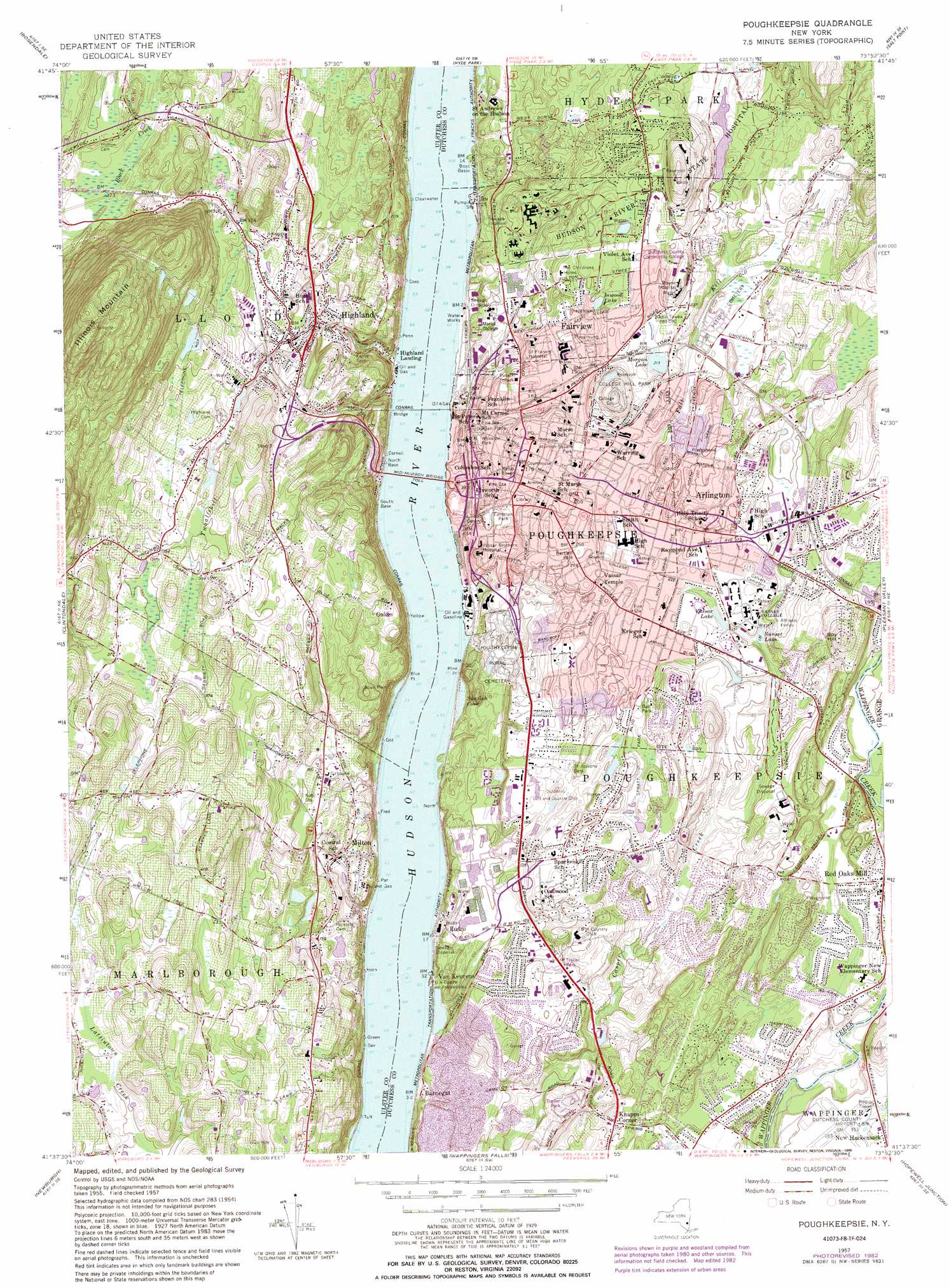
Poughkeepsie Topo Map New York
To zoom in, hover over the map of Poughkeepsie
USGS Topo Quad 41073f8 - 1:24,000 scale
| Topo Map Name: | Poughkeepsie |
| USGS Topo Quad ID: | 41073f8 |
| Print Size: | ca. 21 1/4" wide x 27" high |
| Southeast Coordinates: | 41.625° N latitude / 73.875° W longitude |
| Map Center Coordinates: | 41.6875° N latitude / 73.9375° W longitude |
| U.S. State: | NY |
| Filename: | o41073f8.jpg |
| Download Map JPG Image: | Poughkeepsie topo map 1:24,000 scale |
| Map Type: | Topographic |
| Topo Series: | 7.5´ |
| Map Scale: | 1:24,000 |
| Source of Map Images: | United States Geological Survey (USGS) |
| Alternate Map Versions: |
Poughkeepsie NY 1957, updated 1959 Download PDF Buy paper map Poughkeepsie NY 1957, updated 1982 Download PDF Buy paper map Poughkeepsie NY 1957, updated 1986 Download PDF Buy paper map Poughkeepsie NY 1995, updated 1998 Download PDF Buy paper map Poughkeepsie NY 2010 Download PDF Buy paper map Poughkeepsie NY 2013 Download PDF Buy paper map Poughkeepsie NY 2016 Download PDF Buy paper map |
1:24,000 Topo Quads surrounding Poughkeepsie
Ashokan |
Kingston West |
Kingston East |
Rock City |
Pine Plains |
Mohonk Lake |
Rosendale |
Hyde Park |
Salt Point |
Millbrook |
Gardiner |
Clintondale |
Poughkeepsie |
Pleasant Valley |
Verbank |
Walden |
Newburgh |
Wappingers Falls |
Hopewell Junction |
Poughquag |
Maybrook |
Cornwall |
West Point |
Oscawana Lake |
Lake Carmel |
> Back to 41073e1 at 1:100,000 scale
> Back to 41072a1 at 1:250,000 scale
> Back to U.S. Topo Maps home
Poughkeepsie topo map: Gazetteer
Poughkeepsie: Airports
Dutchess County Airport elevation 47m 154′Mountain Fresh Farm Heliport elevation 113m 370′
Poughkeepsie Main Plant Heliport elevation 0m 0′
Saint Francis Hospital Heliport elevation 51m 167′
Vassar Hospital Heliport elevation 0m 0′
Poughkeepsie: Bays
Sunfish Cove elevation 3m 9′Poughkeepsie: Bridges
Mid-Hudson Bridge elevation 0m 0′Poughkeepsie: Capes
Blue Point elevation 0m 0′Fox Point elevation 1m 3′
Mine Point elevation 27m 88′
Poughkeepsie: Lakes
Inwood Lake elevation 75m 246′Morgan Lake elevation 65m 213′
Sunset Lake elevation 40m 131′
Vassar Lake elevation 46m 150′
Poughkeepsie: Parks
Academy Street Historic District elevation 56m 183′Balding Avenue Historic District elevation 53m 173′
Ballentine Field elevation 53m 173′
Bartlett Park elevation 67m 219′
College Hill Park elevation 73m 239′
Dongan Place elevation 30m 98′
Dwight-Hooker Avenue Historic District elevation 61m 200′
Eastman Park elevation 31m 101′
Fallkill Park elevation 67m 219′
Garfield Place Historic District elevation 53m 173′
Gartland Athletic Field elevation 15m 49′
Kaal Rock Park elevation 5m 16′
Lincoln Center Park elevation 35m 114′
Longview Park elevation 6m 19′
Mansion Square Park elevation 54m 177′
McCann Baseball Field elevation 19m 62′
Mill Street-North Clover Street Historic District elevation 33m 108′
Prentiss Field elevation 51m 167′
Pulaski Park elevation 51m 167′
Reservoir Square elevation 62m 203′
Richard L Skimin Memorial Baseball Field elevation 85m 278′
Shakespeare Garden elevation 43m 141′
Spratt Park elevation 56m 183′
Tenney Stadium At Leonidoff Field elevation 27m 88′
Union Street Historic District elevation 35m 114′
Victor C Waryas Park elevation 2m 6′
Wheaton Park elevation 31m 101′
Poughkeepsie: Populated Places
Arlington elevation 57m 187′Barnegat elevation 3m 9′
Crown Heights elevation 39m 127′
Fairview elevation 66m 216′
Highland elevation 53m 173′
Highland Landing elevation 2m 6′
Hudson Heights elevation 18m 59′
Knapps Corner elevation 53m 173′
M And K Mobile Home Park elevation 69m 226′
Manor Hill Mobile Home Park elevation 70m 229′
Milton elevation 47m 154′
Oakes elevation 89m 291′
Poughkeepsie elevation 62m 203′
Rudco elevation 24m 78′
Spackenkill elevation 50m 164′
The Gables elevation 62m 203′
Van Keurens elevation 9m 29′
Poughkeepsie: Streams
Fall Kill elevation 0m 0′Twaalfskill Creek elevation 0m 0′
Poughkeepsie: Summits
Illinois Mountain elevation 343m 1125′Spy Hill elevation 113m 370′
Poughkeepsie: Woods
Fern Tor elevation 25m 82′Poughkeepsie digital topo map on disk
Buy this Poughkeepsie topo map showing relief, roads, GPS coordinates and other geographical features, as a high-resolution digital map file on DVD:
New York, Vermont, Connecticut & Western Massachusetts
Buy digital topo maps: New York, Vermont, Connecticut & Western Massachusetts