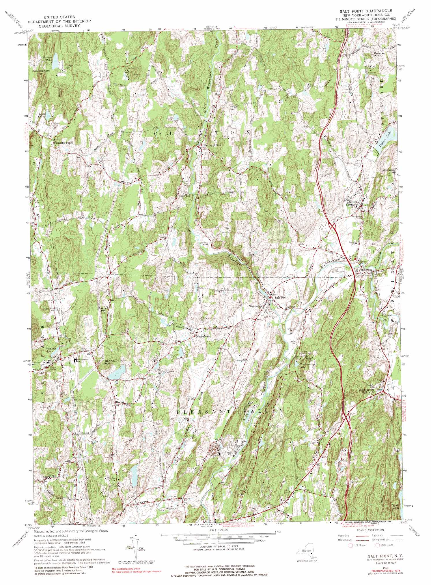
Salt Point Topo Map New York
To zoom in, hover over the map of Salt Point
USGS Topo Quad 41073g7 - 1:24,000 scale
| Topo Map Name: | Salt Point |
| USGS Topo Quad ID: | 41073g7 |
| Print Size: | ca. 21 1/4" wide x 27" high |
| Southeast Coordinates: | 41.75° N latitude / 73.75° W longitude |
| Map Center Coordinates: | 41.8125° N latitude / 73.8125° W longitude |
| U.S. State: | NY |
| Filename: | o41073g7.jpg |
| Download Map JPG Image: | Salt Point topo map 1:24,000 scale |
| Map Type: | Topographic |
| Topo Series: | 7.5´ |
| Map Scale: | 1:24,000 |
| Source of Map Images: | United States Geological Survey (USGS) |
| Alternate Map Versions: |
Salt Point NY 1963, updated 1964 Download PDF Buy paper map Salt Point NY 1963, updated 1970 Download PDF Buy paper map Salt Point NY 1963, updated 1988 Download PDF Buy paper map Salt Point NY 2010 Download PDF Buy paper map Salt Point NY 2013 Download PDF Buy paper map Salt Point NY 2016 Download PDF Buy paper map |
1:24,000 Topo Quads surrounding Salt Point
Woodstock |
Saugerties |
Clermont |
Ancram |
Copake |
Kingston West |
Kingston East |
Rock City |
Pine Plains |
Millerton |
Rosendale |
Hyde Park |
Salt Point |
Millbrook |
Amenia |
Clintondale |
Poughkeepsie |
Pleasant Valley |
Verbank |
Dover Plains |
Newburgh |
Wappingers Falls |
Hopewell Junction |
Poughquag |
Pawling |
> Back to 41073e1 at 1:100,000 scale
> Back to 41072a1 at 1:250,000 scale
> Back to U.S. Topo Maps home
Salt Point topo map: Gazetteer
Salt Point: Airports
State Police Troop K Heliport elevation 97m 318′Salt Point: Lakes
Browns Pond elevation 109m 357′Lake Chloe elevation 104m 341′
Tyrrel Lake elevation 125m 410′
Upton Lake elevation 92m 301′
Victory Lake elevation 86m 282′
Salt Point: Parks
Bloomvale Historic District elevation 85m 278′Friends Park elevation 84m 275′
Salt Point Recreation Park elevation 81m 265′
Salt Point: Populated Places
Clinton Corners elevation 92m 301′Clinton Hollow elevation 101m 331′
Gretna elevation 136m 446′
Hibernia elevation 87m 285′
Hickory Hills elevation 70m 229′
Netherwood elevation 100m 328′
Pleasant Plains elevation 115m 377′
Salt Point elevation 72m 236′
Washington Hollow elevation 100m 328′
Salt Point: Reservoirs
Nooteeming Lake elevation 76m 249′Salt Point: Streams
East Branch Wappinger Creek elevation 73m 239′Great Spring Creek elevation 57m 187′
Little Wappinger Creek elevation 67m 219′
Salt Point: Summits
Barnes Hill elevation 165m 541′Cookingham Hill elevation 173m 567′
Dennis Hill elevation 168m 551′
Jamieson Hill elevation 184m 603′
Prospect Hill elevation 192m 629′
Salt Point digital topo map on disk
Buy this Salt Point topo map showing relief, roads, GPS coordinates and other geographical features, as a high-resolution digital map file on DVD:
New York, Vermont, Connecticut & Western Massachusetts
Buy digital topo maps: New York, Vermont, Connecticut & Western Massachusetts