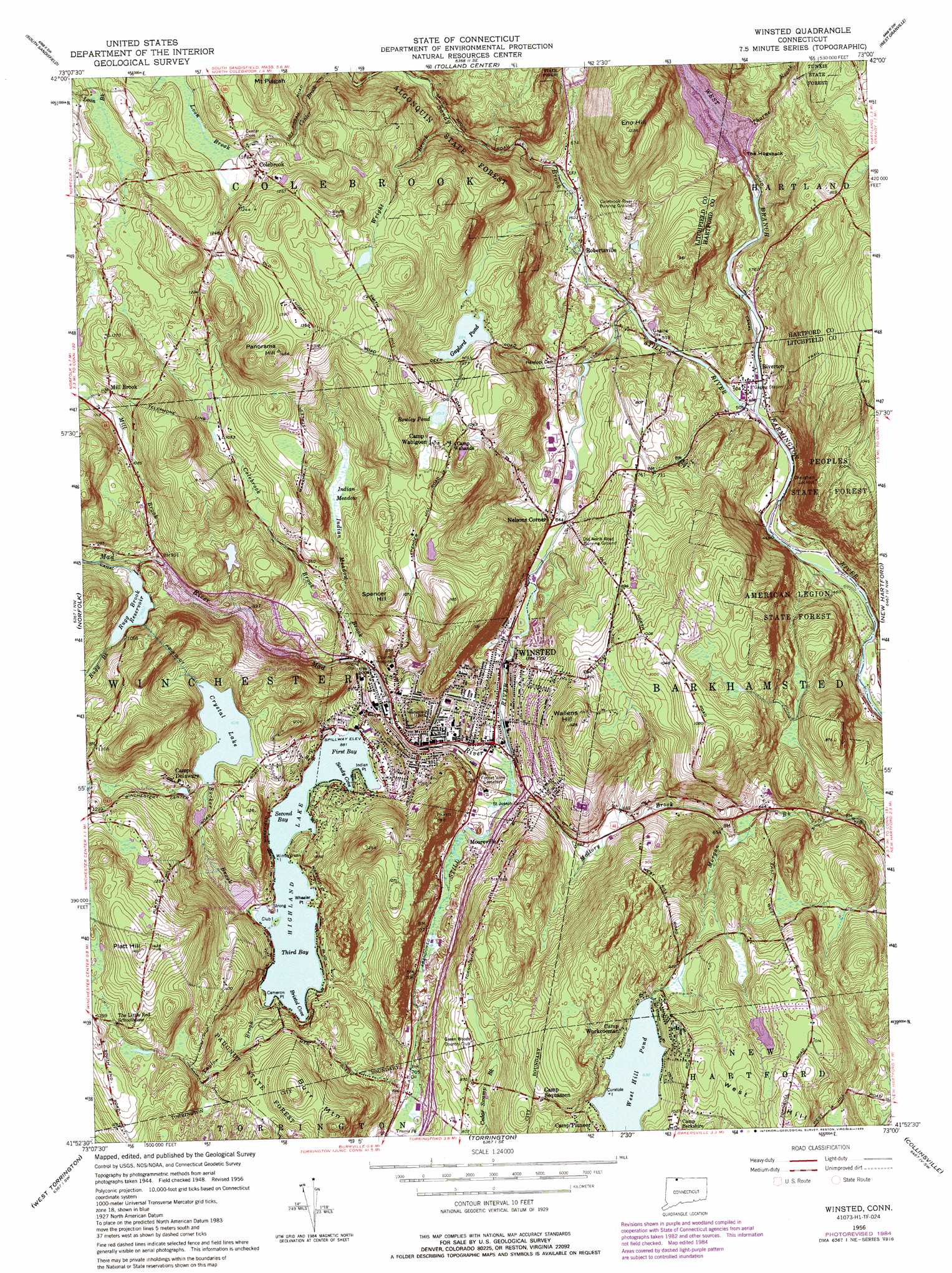
Winsted Topo Map Connecticut
To zoom in, hover over the map of Winsted
USGS Topo Quad 41073h1 - 1:24,000 scale
| Topo Map Name: | Winsted |
| USGS Topo Quad ID: | 41073h1 |
| Print Size: | ca. 21 1/4" wide x 27" high |
| Southeast Coordinates: | 41.875° N latitude / 73° W longitude |
| Map Center Coordinates: | 41.9375° N latitude / 73.0625° W longitude |
| U.S. State: | CT |
| Filename: | o41073h1.jpg |
| Download Map JPG Image: | Winsted topo map 1:24,000 scale |
| Map Type: | Topographic |
| Topo Series: | 7.5´ |
| Map Scale: | 1:24,000 |
| Source of Map Images: | United States Geological Survey (USGS) |
| Alternate Map Versions: |
Winsted CT 1956, updated 1958 Download PDF Buy paper map Winsted CT 1956, updated 1966 Download PDF Buy paper map Winsted CT 1956, updated 1971 Download PDF Buy paper map Winsted CT 1956, updated 1974 Download PDF Buy paper map Winsted CT 1956, updated 1984 Download PDF Buy paper map Winsted CT 1956, updated 1988 Download PDF Buy paper map Winsted CT 1956, updated 1988 Download PDF Buy paper map Winsted CT 2012 Download PDF Buy paper map Winsted CT 2015 Download PDF Buy paper map |
1:24,000 Topo Quads surrounding Winsted
Great Barrington |
Otis |
Woronoco |
||
Ashley Falls |
Tolland Center |
Southwick |
||
South Canaan |
Norfolk |
Winsted |
New Hartford |
Tariffville |
Cornwall |
West Torrington |
Torrington |
Collinsville |
Avon |
New Preston |
Litchfield |
Thomaston |
Bristol |
New Britain |
> Back to 41073e1 at 1:100,000 scale
> Back to 41072a1 at 1:250,000 scale
> Back to U.S. Topo Maps home
Winsted topo map: Gazetteer
Winsted: Bays
Bristol Cove elevation 268m 879′First Bay elevation 268m 879′
Hurtbut Cove elevation 268m 879′
Sandy Cove elevation 268m 879′
Second Bay elevation 268m 879′
Third Bay elevation 268m 879′
Winsted: Bridges
Moore Bridge elevation 149m 488′Winsted: Capes
Cameron Point elevation 270m 885′Indian Point elevation 270m 885′
Wheeler Point elevation 269m 882′
Winsted: Channels
First Narrows elevation 268m 879′Winsted: Crossings
Interchange 46 elevation 226m 741′Winsted: Dams
Crystal Lake Dam elevation 312m 1023′Gaylord Pond Dam elevation 291m 954′
Goodwin Dam elevation 163m 534′
Highland Lake Dam elevation 268m 879′
Laurel Lake Dam elevation 304m 997′
Mad River Dam elevation 255m 836′
Robertsville Dam elevation 202m 662′
Rugg Brook Reservoir Dam elevation 315m 1033′
Schwartz Pond Dam elevation 364m 1194′
Sucker Brook Dam elevation 271m 889′
West Hill Pond Dam elevation 285m 935′
Winsted: Forests
Algonquin State Forest elevation 210m 688′American Legion State Forest elevation 182m 597′
Winsted: Islands
Club Island elevation 271m 889′Curatole Island elevation 286m 938′
Strong Island elevation 269m 882′
Wintergreen Island elevation 268m 879′
Winsted: Lakes
Crystal Lake elevation 310m 1017′Gaylord Pond elevation 291m 954′
Rowley Pond elevation 309m 1013′
Winsted: Parks
Brodie Park elevation 293m 961′Charles Arnold Recreation Area elevation 316m 1036′
Club Island Park elevation 270m 885′
Laurel Park elevation 441m 1446′
Platt Hill State Park elevation 397m 1302′
Winsted: Populated Places
Colebrook elevation 361m 1184′Mill Brook elevation 350m 1148′
Mooreville elevation 233m 764′
Nelsons Corner elevation 196m 643′
Riverton elevation 154m 505′
Robertsville elevation 181m 593′
Winsted elevation 216m 708′
Winsted: Post Offices
Colebrook Post Office elevation 363m 1190′Riverton Post Office elevation 153m 501′
Winsted: Reservoirs
Camp Delaware Pond elevation 329m 1079′Highland Lake elevation 268m 879′
Laurel Lake elevation 304m 997′
Laurel Lake elevation 292m 958′
Mad River Reservoir elevation 255m 836′
Rugg Brook Reservoir elevation 315m 1033′
Schwartz Pond elevation 364m 1194′
Sucker Brook Reservoir elevation 271m 889′
West Branch Reservoir elevation 195m 639′
West Hill Pond elevation 285m 935′
Winsted: Streams
Colebrook Brook elevation 243m 797′Indian Meadow Brook elevation 234m 767′
Loon Brook elevation 350m 1148′
Mad River elevation 212m 695′
Mallory Brook elevation 196m 643′
Mill Brook elevation 300m 984′
Rugg Brook elevation 299m 980′
Sandy Brook elevation 169m 554′
Sandy Brook elevation 161m 528′
Still River elevation 148m 485′
Sucker Brook elevation 269m 882′
Taylor Brook elevation 270m 885′
Thorne Brook elevation 168m 551′
Wright Brook elevation 234m 767′
Winsted: Summits
Babb Hill elevation 398m 1305′Burr Mountain elevation 383m 1256′
Eno Hill elevation 375m 1230′
Panorama Hill elevation 440m 1443′
Platt Hill elevation 443m 1453′
Spencer Hill elevation 365m 1197′
Wallens Hill elevation 339m 1112′
Winsted: Swamps
Indian Meadow elevation 294m 964′Winsted digital topo map on disk
Buy this Winsted topo map showing relief, roads, GPS coordinates and other geographical features, as a high-resolution digital map file on DVD:
New York, Vermont, Connecticut & Western Massachusetts
Buy digital topo maps: New York, Vermont, Connecticut & Western Massachusetts