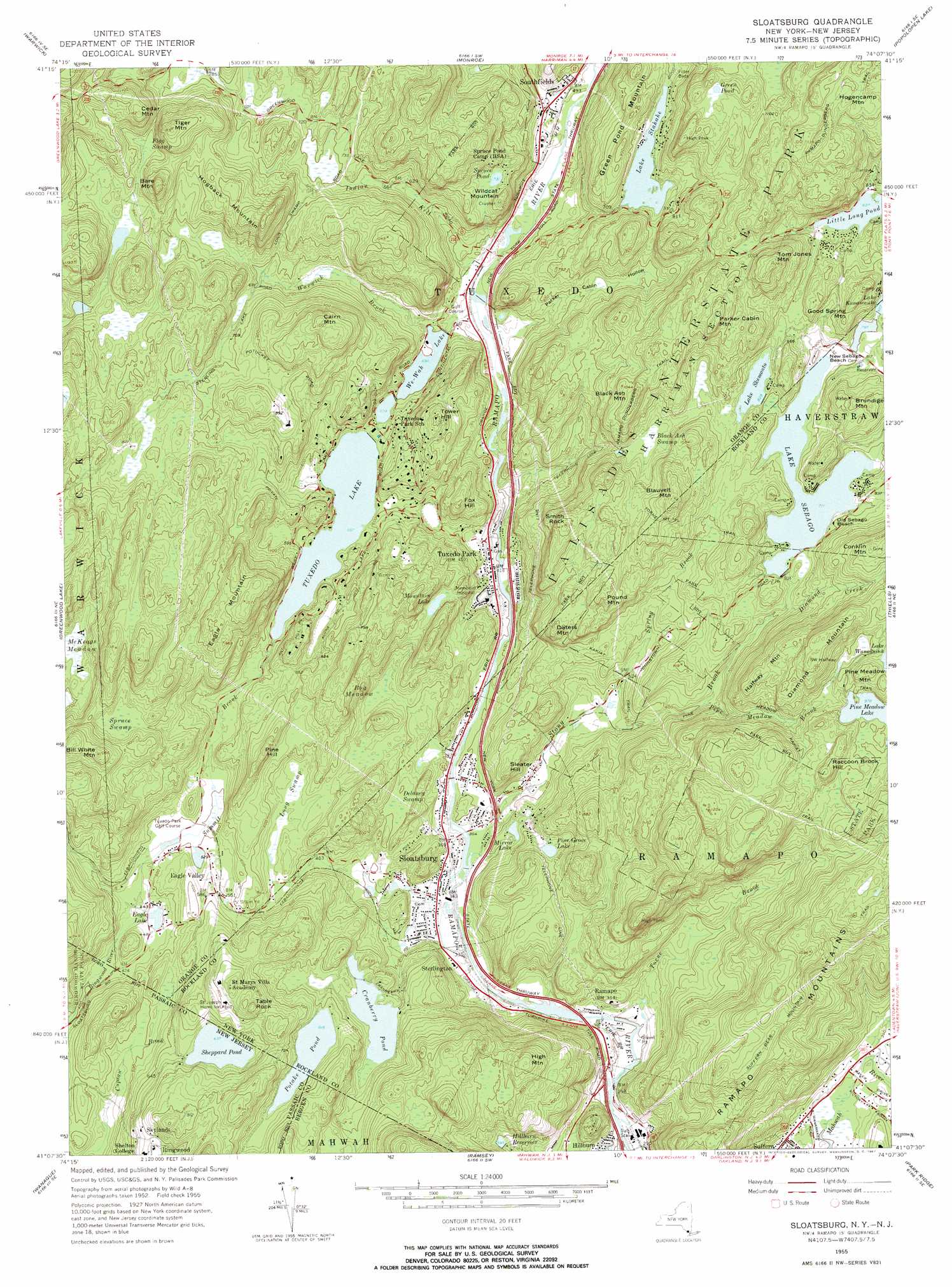
Sloatsburg Topo Map New York
To zoom in, hover over the map of Sloatsburg
USGS Topo Quad 41074b2 - 1:24,000 scale
| Topo Map Name: | Sloatsburg |
| USGS Topo Quad ID: | 41074b2 |
| Print Size: | ca. 21 1/4" wide x 27" high |
| Southeast Coordinates: | 41.125° N latitude / 74.125° W longitude |
| Map Center Coordinates: | 41.1875° N latitude / 74.1875° W longitude |
| U.S. States: | NY, NJ |
| Filename: | o41074b2.jpg |
| Download Map JPG Image: | Sloatsburg topo map 1:24,000 scale |
| Map Type: | Topographic |
| Topo Series: | 7.5´ |
| Map Scale: | 1:24,000 |
| Source of Map Images: | United States Geological Survey (USGS) |
| Alternate Map Versions: |
Sloatsburg NY 1955, updated 1957 Download PDF Buy paper map Sloatsburg NY 1955, updated 1961 Download PDF Buy paper map Sloatsburg NY 2011 Download PDF Buy paper map Sloatsburg NY 2013 Download PDF Buy paper map Sloatsburg NY 2016 Download PDF Buy paper map |
1:24,000 Topo Quads surrounding Sloatsburg
Middletown |
Goshen |
Maybrook |
Cornwall |
West Point |
Pine Island |
Warwick |
Monroe |
Popolopen Lake |
Peekskill |
Wawayanda |
Greenwood Lake |
Sloatsburg |
Thiells |
Haverstraw |
Newfoundland |
Wanaque |
Ramsey |
Park Ridge |
Nyack |
Boonton |
Pompton Plains |
Paterson |
Hackensack |
Yonkers |
> Back to 41074a1 at 1:100,000 scale
> Back to 41074a1 at 1:250,000 scale
> Back to U.S. Topo Maps home
Sloatsburg topo map: Gazetteer
Sloatsburg: Beaches
New Sebago Beach elevation 235m 770′Old Sebago Beach elevation 237m 777′
Sloatsburg: Crossings
Interchange 15A elevation 93m 305′Sloatsburg: Lakes
Green Pond elevation 314m 1030′Little Long Pond elevation 252m 826′
Mirror Lake elevation 134m 439′
Mountain Lake elevation 197m 646′
Pine Meadow Lake elevation 298m 977′
Sheppard Pond elevation 194m 636′
Spruce Pond elevation 223m 731′
Sloatsburg: Parks
Dater Mountain County Park elevation 146m 479′Louis E Euvard Memorial Field elevation 165m 541′
Tuxedo Memorial Park elevation 132m 433′
Sloatsburg: Populated Places
Clinton Woods elevation 258m 846′Eagle Valley elevation 172m 564′
Laurel Ridge elevation 279m 915′
Ramapo elevation 101m 331′
Skylands elevation 212m 695′
Sloatsburg elevation 105m 344′
Southfields elevation 154m 505′
Sterlington elevation 101m 331′
Tuxedo Park elevation 124m 406′
Sloatsburg: Reservoirs
Cranberry Pond elevation 152m 498′Eagle Lake elevation 136m 446′
Hillburn Reservoir elevation 179m 587′
Lake Kanawauke elevation 249m 816′
Lake Sebago elevation 231m 757′
Lake Skemonto elevation 243m 797′
Lake Stahahe elevation 220m 721′
Pine Grove Lake elevation 168m 551′
Potake Pond elevation 188m 616′
Tuxedo Lake elevation 170m 557′
We-Wah Lake elevation 145m 475′
Sloatsburg: Streams
Diamond Creek elevation 218m 715′Indian Kill elevation 141m 462′
Pine Meadow Brook elevation 186m 610′
Spring Brook elevation 133m 436′
Stony Brook elevation 104m 341′
Summit Brook elevation 135m 442′
Torne Brook elevation 86m 282′
Warwick Brook elevation 150m 492′
Whitney Brook elevation 238m 780′
Sloatsburg: Summits
Bare Mountain elevation 342m 1122′Bill White Mountain elevation 321m 1053′
Black Ash Mountain elevation 336m 1102′
Blauvelt Mountain elevation 355m 1164′
Brundige Mountain elevation 311m 1020′
Cairn Mountain elevation 343m 1125′
Cedar Mountain elevation 355m 1164′
Daters Mountain elevation 287m 941′
Diamond Mountain elevation 378m 1240′
Eagle Mountain elevation 325m 1066′
Fox Hill elevation 234m 767′
Good Spring Mountain elevation 320m 1049′
Green Pond Mountain elevation 276m 905′
Halfway Mountain elevation 328m 1076′
High Mountain elevation 291m 954′
Hogback Mountain elevation 332m 1089′
Parker Cabin Mountain elevation 381m 1250′
Pine Hill elevation 260m 853′
Pine Meadow Mountain elevation 340m 1115′
Pound Mountain elevation 313m 1026′
Raccoon Brook Hill elevation 353m 1158′
Sleater Hill elevation 201m 659′
Smith Rock elevation 318m 1043′
Table Rock elevation 279m 915′
Tiger Mountain elevation 355m 1164′
Tom Jones Mountain elevation 387m 1269′
Tower Hill elevation 275m 902′
Wildcat Mountain elevation 254m 833′
Sloatsburg: Swamps
Black Ash Swamp elevation 247m 810′Bog Meadow elevation 156m 511′
Delaney Swamp elevation 149m 488′
Flag Swamp elevation 260m 853′
Long Swamp elevation 162m 531′
McKeags Meadow elevation 220m 721′
Spruce Swamp elevation 246m 807′
Sloatsburg: Trails
Kakiat Trail elevation 270m 885′Pine Meadow Trail elevation 284m 931′
Ramapo-Dunderberg Trail elevation 380m 1246′
Sloatsburg: Valleys
Parker Cabin Hollow elevation 137m 449′Sloatsburg digital topo map on disk
Buy this Sloatsburg topo map showing relief, roads, GPS coordinates and other geographical features, as a high-resolution digital map file on DVD:
New York, Vermont, Connecticut & Western Massachusetts
Buy digital topo maps: New York, Vermont, Connecticut & Western Massachusetts