Popolopen Lake Topo Map New York
To zoom in, hover over the map of Popolopen Lake
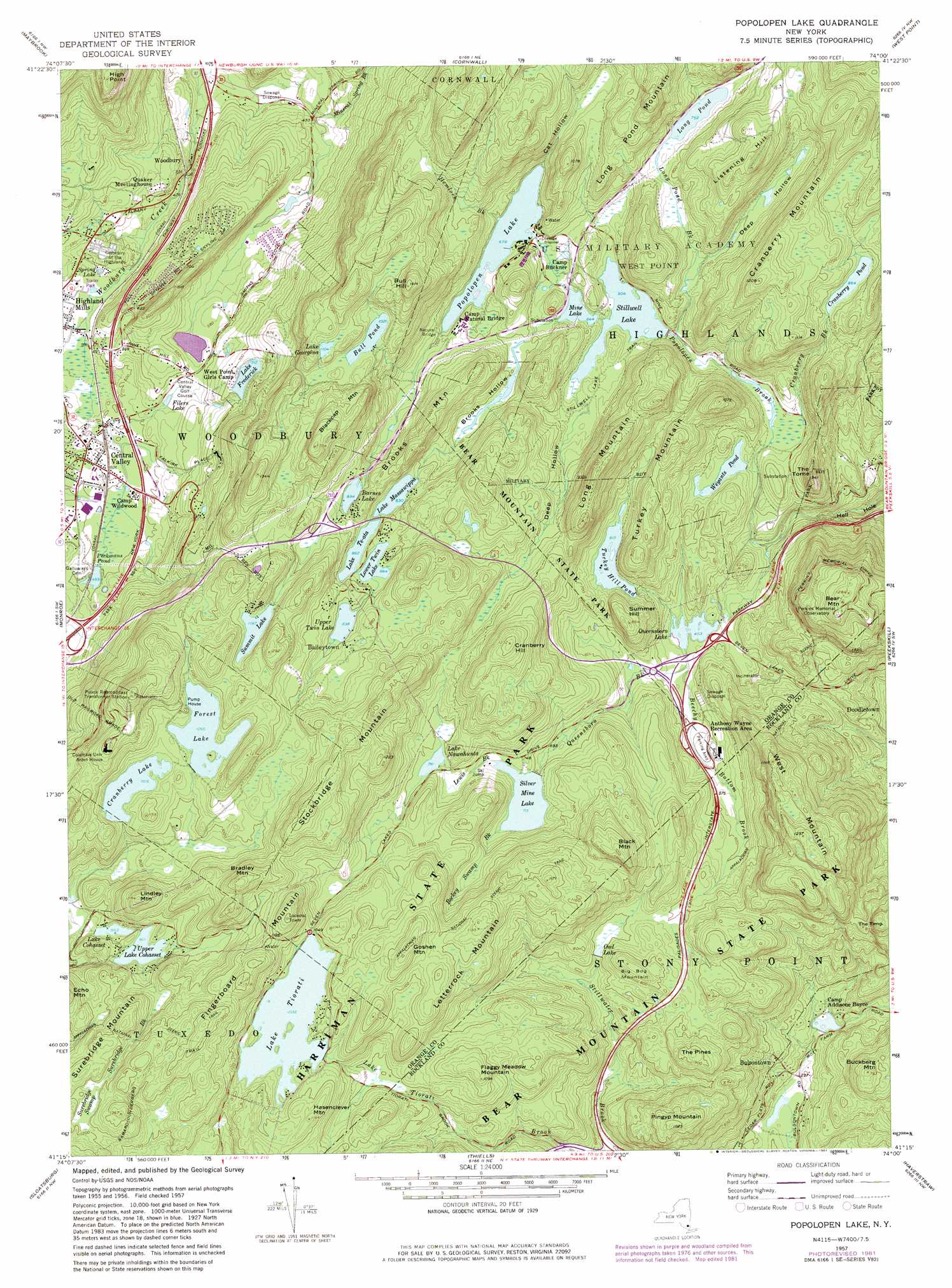
USGS Topo Quad 41074c1 - 1:24,000 scale
| Topo Map Name: | Popolopen Lake |
| USGS Topo Quad ID: | 41074c1 |
| Print Size: | ca. 21 1/4" wide x 27" high |
| Southeast Coordinates: | 41.25° N latitude / 74° W longitude |
| Map Center Coordinates: | 41.3125° N latitude / 74.0625° W longitude |
| U.S. State: | NY |
| Filename: | o41074c1.jpg |
| Download Map JPG Image: | Popolopen Lake topo map 1:24,000 scale |
| Map Type: | Topographic |
| Topo Series: | 7.5´ |
| Map Scale: | 1:24,000 |
| Source of Map Images: | United States Geological Survey (USGS) |
| Alternate Map Versions: |
Popolopen Lake NY 1946, updated 1947 Download PDF Buy paper map Popolopen Lake NY 1947 Download PDF Buy paper map Popolopen Lake NY 1957, updated 1959 Download PDF Buy paper map Popolopen Lake NY 1957, updated 1964 Download PDF Buy paper map Popolopen Lake NY 1957, updated 1970 Download PDF Buy paper map Popolopen Lake NY 1957, updated 1981 Download PDF Buy paper map Popolopen Lake NY 1957, updated 1981 Download PDF Buy paper map Popolopen Lake NY 1994, updated 1999 Download PDF Buy paper map Popolopen Lake NY 2010 Download PDF Buy paper map Popolopen Lake NY 2013 Download PDF Buy paper map Popolopen Lake NY 2016 Download PDF Buy paper map |
1:24,000 Topo Quads surrounding Popolopen Lake
Pine Bush |
Walden |
Newburgh |
Wappingers Falls |
Hopewell Junction |
Goshen |
Maybrook |
Cornwall |
West Point |
Oscawana Lake |
Warwick |
Monroe |
Popolopen Lake |
Peekskill |
Mohegan Lake |
Greenwood Lake |
Sloatsburg |
Thiells |
Haverstraw |
Ossining |
Wanaque |
Ramsey |
Park Ridge |
Nyack |
White Plains |
> Back to 41074a1 at 1:100,000 scale
> Back to 41074a1 at 1:250,000 scale
> Back to U.S. Topo Maps home
Popolopen Lake topo map: Gazetteer
Popolopen Lake: Bays
Hell Hole elevation 58m 190′Popolopen Lake: Capes
High Point elevation 419m 1374′Popolopen Lake: Crossings
Interchange 16 elevation 167m 547′Popolopen Lake: Lakes
Barnes Lake elevation 272m 892′Cranberry Pond elevation 263m 862′
Filers Lake elevation 164m 538′
Lake Frederick elevation 217m 711′
Lake Georgina elevation 336m 1102′
Lake Massawippa elevation 253m 830′
Lake Te-Ata elevation 262m 859′
Long Pond elevation 229m 751′
Lower Twin Lake elevation 263m 862′
Mine Lake elevation 196m 643′
Owl Lake elevation 208m 682′
Peckermans Pond elevation 150m 492′
Popolopen Lake elevation 206m 675′
Spring Lake elevation 146m 479′
Turkey Hill Pond elevation 183m 600′
Upper Twin Lake elevation 273m 895′
Weyants Pond elevation 167m 547′
Popolopen Lake: Parks
Anthony Wayne Recreation Area elevation 149m 488′Palisades Interstate Park elevation 295m 967′
Popolopen Lake: Populated Places
Baileytown elevation 293m 961′Bulsontown elevation 130m 426′
Central Valley elevation 159m 521′
Doodletown (historical) elevation 148m 485′
Lakeside Mobile Home Park elevation 146m 479′
Rock Terrace Mobile Home Park elevation 105m 344′
Woodbury elevation 147m 482′
Popolopen Lake: Reservoirs
Bull Pond elevation 311m 1020′Cranberry Lake elevation 309m 1013′
Forest Lake elevation 320m 1049′
Lake Cohasset elevation 258m 846′
Lake Nawahunta elevation 238m 780′
Lake Tiorati elevation 314m 1030′
Queensboro Lake elevation 139m 456′
Silver Mine Lake elevation 216m 708′
Stilwell Lake elevation 184m 603′
Summit Lake elevation 325m 1066′
Upper Lake Cohasset elevation 275m 902′
Popolopen Lake: Streams
Beechy Bottom Brook elevation 138m 452′Bockey Swamp Brook elevation 218m 715′
Cranberry Brook elevation 162m 531′
Hemlock Brook elevation 207m 679′
Lewis Brook elevation 218m 715′
Long Pond Brook elevation 171m 561′
Mineral Spring Brook elevation 103m 337′
Queensboro Brook elevation 139m 456′
Stillwater Brook elevation 122m 400′
Surebridge Brook elevation 275m 902′
Popolopen Lake: Summits
Bear Mountain elevation 394m 1292′Big Bog Mountain elevation 269m 882′
Black Mountain elevation 355m 1164′
Blackcap Mountain elevation 416m 1364′
Bradley Mountain elevation 416m 1364′
Brooks Mountain elevation 325m 1066′
Buckberg Mountain elevation 241m 790′
Bull Hill elevation 423m 1387′
Cranberry Hill elevation 374m 1227′
Cranberry Mountain elevation 366m 1200′
Fingerboard Mountain elevation 420m 1377′
Flaggy Meadow Mountain elevation 331m 1085′
Goshen Mountain elevation 371m 1217′
Hasenclever Mountain elevation 363m 1190′
Letterrock Mountain elevation 371m 1217′
Lindley Mountain elevation 390m 1279′
Listening Hill elevation 362m 1187′
Long Mountain elevation 355m 1164′
Long Pond Mountain elevation 384m 1259′
Pingyp Mountain elevation 310m 1017′
Stockbridge Mountain elevation 402m 1318′
Summer Hill elevation 258m 846′
The Torne elevation 287m 941′
Turkey Mountain elevation 286m 938′
West Mountain elevation 382m 1253′
Popolopen Lake: Swamps
Owl Swamp elevation 208m 682′Surebridge Swamp elevation 357m 1171′
Popolopen Lake: Trails
Stillwell Lake Trail elevation 200m 656′Popolopen Lake: Valleys
Brooks Hollow elevation 198m 649′Cat Hollow elevation 207m 679′
Deep Hollow elevation 193m 633′
Deep Hollow elevation 206m 675′
Popolopen Lake: Woods
The Pines elevation 285m 935′Popolopen Lake digital topo map on disk
Buy this Popolopen Lake topo map showing relief, roads, GPS coordinates and other geographical features, as a high-resolution digital map file on DVD:
New York, Vermont, Connecticut & Western Massachusetts
Buy digital topo maps: New York, Vermont, Connecticut & Western Massachusetts