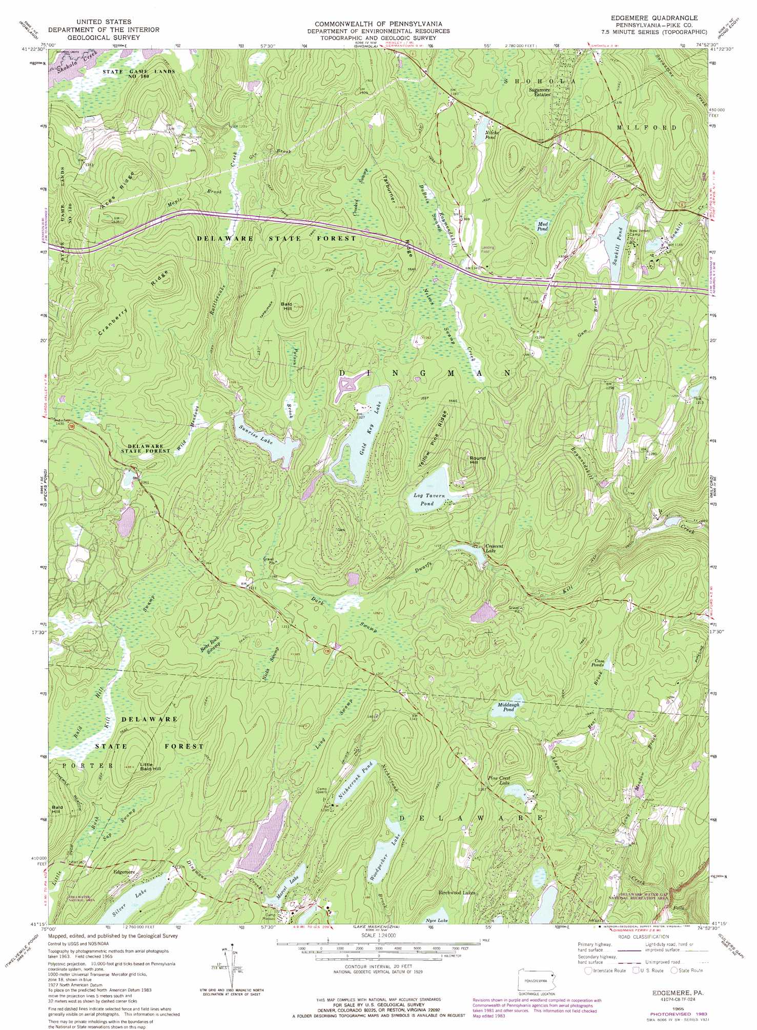
Edgemere Topo Map Pennsylvania
To zoom in, hover over the map of Edgemere
USGS Topo Quad 41074c8 - 1:24,000 scale
| Topo Map Name: | Edgemere |
| USGS Topo Quad ID: | 41074c8 |
| Print Size: | ca. 21 1/4" wide x 27" high |
| Southeast Coordinates: | 41.25° N latitude / 74.875° W longitude |
| Map Center Coordinates: | 41.3125° N latitude / 74.9375° W longitude |
| U.S. State: | PA |
| Filename: | o41074c8.jpg |
| Download Map JPG Image: | Edgemere topo map 1:24,000 scale |
| Map Type: | Topographic |
| Topo Series: | 7.5´ |
| Map Scale: | 1:24,000 |
| Source of Map Images: | United States Geological Survey (USGS) |
| Alternate Map Versions: |
Edgemere PA 1965, updated 1967 Download PDF Buy paper map Edgemere PA 1965, updated 1974 Download PDF Buy paper map Edgemere PA 1965, updated 1984 Download PDF Buy paper map Edgemere PA 1965, updated 1988 Download PDF Buy paper map Edgemere PA 1992, updated 1995 Download PDF Buy paper map Edgemere PA 2010 Download PDF Buy paper map Edgemere PA 2013 Download PDF Buy paper map Edgemere PA 2016 Download PDF Buy paper map |
1:24,000 Topo Quads surrounding Edgemere
White Mills |
Narrowsburg |
Eldred |
Highland Lake |
Hartwood |
Hawley |
Rowland |
Shohola |
Pond Eddy |
Port Jervis North |
Promised Land |
Pecks Pond |
Edgemere |
Milford |
Port Jervis South |
Skytop |
Twelvemile Pond |
Lake Maskenozha |
Culvers Gap |
Branchville |
East Stroudsburg |
Bushkill |
Flatbrookville |
Newton West |
Newton East |
> Back to 41074a1 at 1:100,000 scale
> Back to 41074a1 at 1:250,000 scale
> Back to U.S. Topo Maps home
Edgemere topo map: Gazetteer
Edgemere: Airports
Myer Airport elevation 442m 1450′Edgemere: Areas
Stillwater Natural Area elevation 388m 1272′Edgemere: Dams
Adams Brook Dam elevation 337m 1105′Beaver Pond Dam elevation 360m 1181′
Camp Massad Dam elevation 359m 1177′
Camp Netimus Dam elevation 289m 948′
Cresent Lake Dam elevation 374m 1227′
Felix Fold Dam elevation 352m 1154′
Gun Club Dam elevation 316m 1036′
Marcel Lake Dam elevation 376m 1233′
Pocono Woodland Lake Dam elevation 339m 1112′
Sawkill Dam elevation 369m 1210′
Sawkill Pond Dam elevation 370m 1213′
Edgemere: Flats
Wild Meadows elevation 403m 1322′Edgemere: Lakes
Log Tavern Pond elevation 397m 1302′Nichecronk Pond elevation 388m 1272′
Nitche Pond elevation 411m 1348′
Woodpecker Lake elevation 360m 1181′
Edgemere: Populated Places
Birchwood Lakes elevation 344m 1128′Edgemere elevation 421m 1381′
Frenchtown elevation 417m 1368′
Gold Key Lake elevation 419m 1374′
Pocono Mountain Woodland Lakes elevation 389m 1276′
Sagamore Estates elevation 446m 1463′
Spencer Corner elevation 340m 1115′
Sunrise Lake elevation 447m 1466′
Edgemere: Reservoirs
Adams Brook Reservoir elevation 337m 1105′Beaver Pond elevation 360m 1181′
Camp Netimus Lake elevation 289m 948′
Case Ponds elevation 351m 1151′
Crescent Lake elevation 366m 1200′
Gold Key Lake elevation 403m 1322′
Marcel Lake elevation 376m 1233′
Middaugh Pond elevation 356m 1167′
Pine Crest Lake elevation 343m 1125′
Pocono Woodland Lake elevation 339m 1112′
Sawkill Pond elevation 371m 1217′
Silver Lake elevation 399m 1309′
Sunrise Lake elevation 400m 1312′
Edgemere: Ridges
Aces Ridge elevation 440m 1443′Cranberry Ridge elevation 468m 1535′
Tarburner Ridge elevation 446m 1463′
Yellow Pine Ridge elevation 440m 1443′
Edgemere: Streams
Bear Brook elevation 349m 1145′Dwarfs Kill elevation 282m 925′
Gin Brook elevation 367m 1204′
Gum Brook elevation 371m 1217′
Long Meadow Brook elevation 289m 948′
Maple Brook elevation 367m 1204′
Poison Brook elevation 400m 1312′
Edgemere: Summits
Bald Hill elevation 468m 1535′Bald Hill elevation 467m 1532′
Little Bald Hill elevation 461m 1512′
Round Hill elevation 446m 1463′
Edgemere: Swamps
Bald Hill Swamp elevation 413m 1354′Bear Rock Swamp elevation 419m 1374′
Crooked Swamp elevation 424m 1391′
Dark Swamp elevation 390m 1279′
DuBois Swamp elevation 405m 1328′
Long Swamp elevation 399m 1309′
Nelson Swamp elevation 401m 1315′
Nicks Swamp elevation 408m 1338′
Sap Swamp elevation 395m 1295′
Townsend Swamp elevation 385m 1263′
Edgemere: Trails
Bald Hill Trail elevation 388m 1272′Maple Brook Trail elevation 433m 1420′
Edgemere digital topo map on disk
Buy this Edgemere topo map showing relief, roads, GPS coordinates and other geographical features, as a high-resolution digital map file on DVD:
New York, Vermont, Connecticut & Western Massachusetts
Buy digital topo maps: New York, Vermont, Connecticut & Western Massachusetts