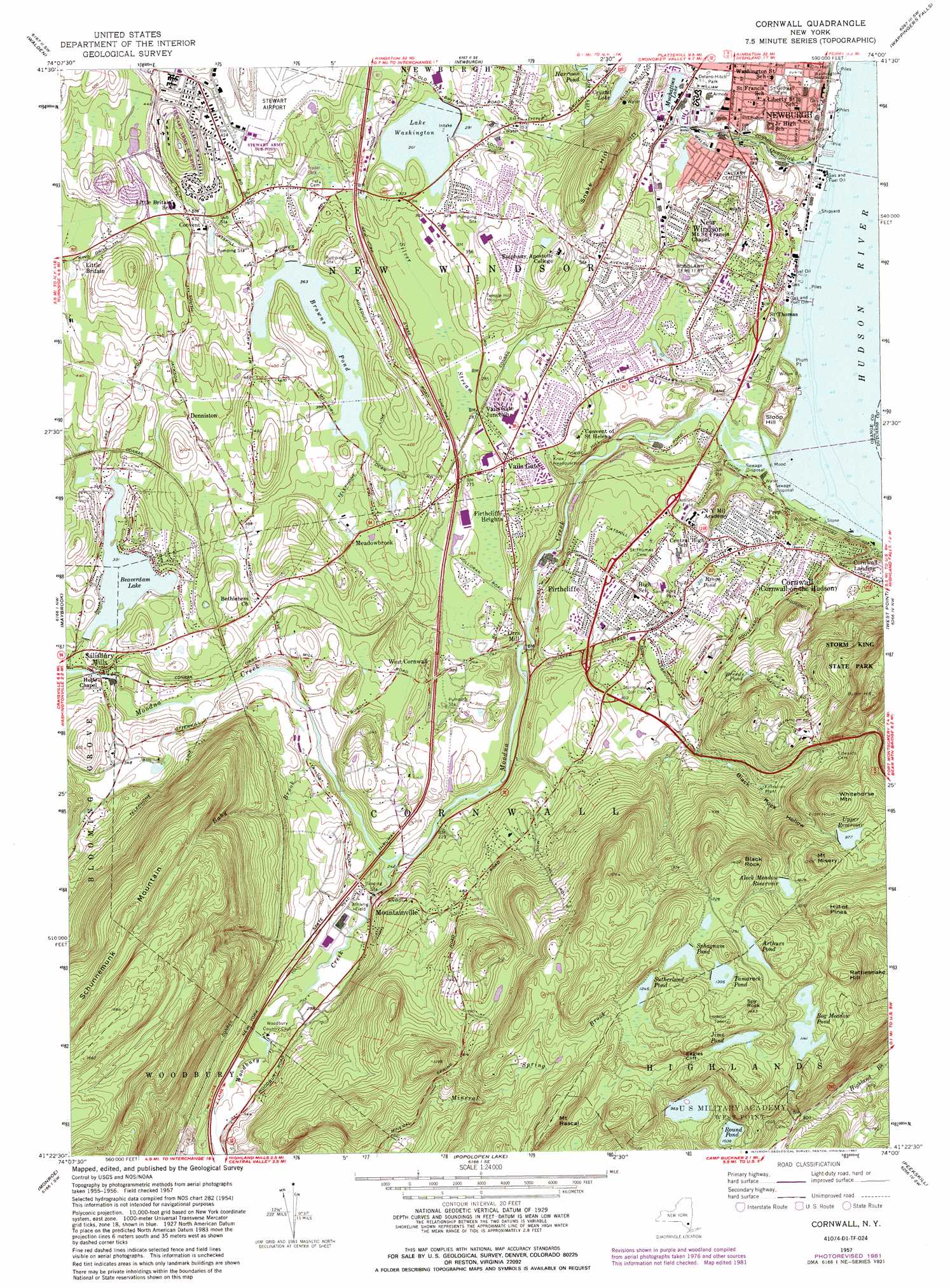
Cornwall Topo Map New York
To zoom in, hover over the map of Cornwall
USGS Topo Quad 41074d1 - 1:24,000 scale
| Topo Map Name: | Cornwall |
| USGS Topo Quad ID: | 41074d1 |
| Print Size: | ca. 21 1/4" wide x 27" high |
| Southeast Coordinates: | 41.375° N latitude / 74° W longitude |
| Map Center Coordinates: | 41.4375° N latitude / 74.0625° W longitude |
| U.S. State: | NY |
| Filename: | o41074d1.jpg |
| Download Map JPG Image: | Cornwall topo map 1:24,000 scale |
| Map Type: | Topographic |
| Topo Series: | 7.5´ |
| Map Scale: | 1:24,000 |
| Source of Map Images: | United States Geological Survey (USGS) |
| Alternate Map Versions: |
Cornwall NY 1947 Download PDF Buy paper map Cornwall NY 1947 Download PDF Buy paper map Cornwall NY 1957, updated 1959 Download PDF Buy paper map Cornwall NY 1957, updated 1965 Download PDF Buy paper map Cornwall NY 1957, updated 1973 Download PDF Buy paper map Cornwall NY 1957, updated 1981 Download PDF Buy paper map Cornwall NY 1957, updated 1987 Download PDF Buy paper map Cornwall-on-Hudson NY 1994, updated 2000 Download PDF Buy paper map Cornwall-on-Hudson NY 2010 Download PDF Buy paper map Cornwall-on-Hudson NY 2013 Download PDF Buy paper map Cornwall-on-Hudson NY 2016 Download PDF Buy paper map |
1:24,000 Topo Quads surrounding Cornwall
Napanoch |
Gardiner |
Clintondale |
Poughkeepsie |
Pleasant Valley |
Pine Bush |
Walden |
Newburgh |
Wappingers Falls |
Hopewell Junction |
Goshen |
Maybrook |
Cornwall |
West Point |
Oscawana Lake |
Warwick |
Monroe |
Popolopen Lake |
Peekskill |
Mohegan Lake |
Greenwood Lake |
Sloatsburg |
Thiells |
Haverstraw |
Ossining |
> Back to 41074a1 at 1:100,000 scale
> Back to 41074a1 at 1:250,000 scale
> Back to U.S. Topo Maps home
Cornwall topo map: Gazetteer
Cornwall: Capes
Plum Point elevation 21m 68′Cornwall: Cliffs
Eagles Cliff elevation 378m 1240′Cornwall: Lakes
Crystal Lake elevation 47m 154′Harrison Pond elevation 61m 200′
Jims Pond elevation 381m 1250′
Muchattoes Lake elevation 40m 131′
Rings Pond elevation 70m 229′
Sutherland Pond elevation 380m 1246′
Cornwall: Parks
Ace of Diamonds elevation 59m 193′Buttermilk Park elevation 36m 118′
Chestnut Grove Park elevation 114m 374′
Curtis E Remfry Little League Complex elevation 45m 147′
Delano-Hitch Park elevation 50m 164′
Laurel Creek Park elevation 87m 285′
Little Falls Park elevation 42m 137′
Memorial Swimming Pool elevation 53m 173′
Monument Park elevation 68m 223′
Riverlight Park elevation 72m 236′
Ruscitti Park elevation 67m 219′
San Giacomo Park elevation 134m 439′
Sand Ring Park elevation 68m 223′
Sloop Hill State Unique Area elevation 36m 118′
Storm King State Park elevation 339m 1112′
Temple Hill Monument elevation 122m 400′
Washington Headquarters Monument elevation 30m 98′
Cornwall: Populated Places
Butter Hill Estates elevation 39m 127′Cornwall Landing elevation 4m 13′
Cornwall-on-Hudson elevation 51m 167′
Denniston elevation 122m 400′
Downey Farms elevation 113m 370′
Firthcliffe elevation 91m 298′
Firthcliffe Heights elevation 91m 298′
Meadowbrook elevation 103m 337′
Mountainville elevation 91m 298′
New Windsor elevation 49m 160′
Orrs Mill elevation 85m 278′
Paradise Mobile Home Park elevation 6m 19′
Salisbury Mills elevation 93m 305′
Stewart Terrace elevation 126m 413′
Vails Gate elevation 86m 282′
Vails Gate Junction elevation 85m 278′
Walters Trailer Village elevation 106m 347′
West Cornwall elevation 98m 321′
Windsor Crest elevation 93m 305′
Cornwall: Reservoirs
Aleck Meadow Reservoir elevation 313m 1026′Arthurs Pond elevation 372m 1220′
Beaverdam Lake elevation 101m 331′
Bog Meadow Pond elevation 347m 1138′
Breeds Pond elevation 129m 423′
Browns Pond elevation 111m 364′
Lake Washington elevation 91m 298′
Little Falls Pond elevation 41m 134′
Round Pond elevation 324m 1062′
Sphagnum Pond elevation 381m 1250′
Tamarack Pond elevation 395m 1295′
Upper Reservoir elevation 298m 977′
Cornwall: Streams
Baby Brook elevation 69m 226′Moodna Creek elevation 0m 0′
Quassaic Creek elevation 2m 6′
Silver Stream elevation 20m 65′
Woodbury Creek elevation 65m 213′
Cornwall: Summits
Black Rock elevation 424m 1391′Deer Hill elevation 270m 885′
Hill of Pines elevation 419m 1374′
Honey Hill elevation 345m 1131′
Mount Misery elevation 387m 1269′
Mount Rascal elevation 424m 1391′
Rattlesnake Hill elevation 429m 1407′
Schunnemunk Mountain elevation 507m 1663′
Sloop Hill elevation 39m 127′
Snake Hill elevation 211m 692′
Spy Rock elevation 441m 1446′
Whitehorse Mountain elevation 378m 1240′
Cornwall: Valleys
Black Rock Hollow elevation 116m 380′Cornwall digital topo map on disk
Buy this Cornwall topo map showing relief, roads, GPS coordinates and other geographical features, as a high-resolution digital map file on DVD:
New York, Vermont, Connecticut & Western Massachusetts
Buy digital topo maps: New York, Vermont, Connecticut & Western Massachusetts