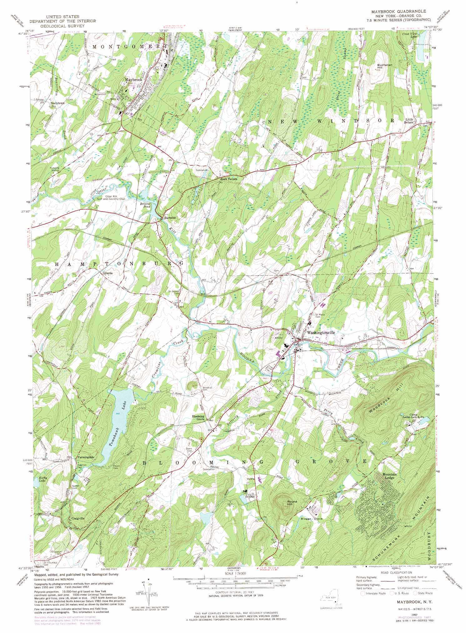
Maybrook Topo Map New York
To zoom in, hover over the map of Maybrook
USGS Topo Quad 41074d2 - 1:24,000 scale
| Topo Map Name: | Maybrook |
| USGS Topo Quad ID: | 41074d2 |
| Print Size: | ca. 21 1/4" wide x 27" high |
| Southeast Coordinates: | 41.375° N latitude / 74.125° W longitude |
| Map Center Coordinates: | 41.4375° N latitude / 74.1875° W longitude |
| U.S. State: | NY |
| Filename: | o41074d2.jpg |
| Download Map JPG Image: | Maybrook topo map 1:24,000 scale |
| Map Type: | Topographic |
| Topo Series: | 7.5´ |
| Map Scale: | 1:24,000 |
| Source of Map Images: | United States Geological Survey (USGS) |
| Alternate Map Versions: |
Maybrook NY 1957, updated 1959 Download PDF Buy paper map Maybrook NY 1957, updated 1966 Download PDF Buy paper map Maybrook NY 1957, updated 1974 Download PDF Buy paper map Maybrook NY 1957, updated 1981 Download PDF Buy paper map Maybrook NY 2010 Download PDF Buy paper map Maybrook NY 2013 Download PDF Buy paper map Maybrook NY 2016 Download PDF Buy paper map |
1:24,000 Topo Quads surrounding Maybrook
Ellenville |
Napanoch |
Gardiner |
Clintondale |
Poughkeepsie |
Wurtsboro |
Pine Bush |
Walden |
Newburgh |
Wappingers Falls |
Middletown |
Goshen |
Maybrook |
Cornwall |
West Point |
Pine Island |
Warwick |
Monroe |
Popolopen Lake |
Peekskill |
Wawayanda |
Greenwood Lake |
Sloatsburg |
Thiells |
Haverstraw |
> Back to 41074a1 at 1:100,000 scale
> Back to 41074a1 at 1:250,000 scale
> Back to U.S. Topo Maps home
Maybrook topo map: Gazetteer
Maybrook: Basins
Blaggs Clove elevation 169m 554′Maybrook: Lakes
Crest View Lake elevation 136m 446′Korby Lake elevation 142m 465′
Maybrook: Parks
L Vern Allen Park elevation 91m 298′Mays Field elevation 93m 305′
Maybrook: Populated Places
Arbor Valley elevation 114m 374′Blooming Grove elevation 109m 357′
Brookview Acres Mobile Home Park elevation 93m 305′
Burnside elevation 105m 344′
Canterbury Estates elevation 147m 482′
Craigville elevation 130m 426′
Farmingdale elevation 110m 360′
Girarde elevation 122m 400′
Hampton Trails elevation 122m 400′
Kimberly Estates elevation 120m 393′
Little Britain elevation 139m 456′
Maybrook elevation 128m 419′
Mountain Lodge elevation 239m 784′
Neelytown elevation 111m 364′
Otter Kill Estates elevation 105m 344′
Rock Tavern elevation 127m 416′
Rural Ridge elevation 136m 446′
Tappan Hill elevation 103m 337′
Washingtonville elevation 93m 305′
Woodfield elevation 104m 341′
Maybrook: Post Offices
Little Britain Post Office (historical) elevation 140m 459′Rock Tavern Post Office elevation 126m 413′
Maybrook: Reservoirs
Browns Pond elevation 98m 321′Lake Hildegard elevation 124m 406′
Tomahawk Lake elevation 102m 334′
Toro Hill Pond elevation 107m 351′
Maybrook: Streams
Beaverdam Brook elevation 102m 334′Cromline Creek elevation 91m 298′
Otter Kill elevation 91m 298′
Perry Creek elevation 84m 275′
Satterly Creek elevation 91m 298′
Seely Brook elevation 112m 367′
Maybrook: Summits
Buchanan Hill elevation 198m 649′Round Hill elevation 288m 944′
Woodcock Hill elevation 311m 1020′
Maybrook: Swamps
Great Swamp elevation 140m 459′Maybrook digital topo map on disk
Buy this Maybrook topo map showing relief, roads, GPS coordinates and other geographical features, as a high-resolution digital map file on DVD:
New York, Vermont, Connecticut & Western Massachusetts
Buy digital topo maps: New York, Vermont, Connecticut & Western Massachusetts