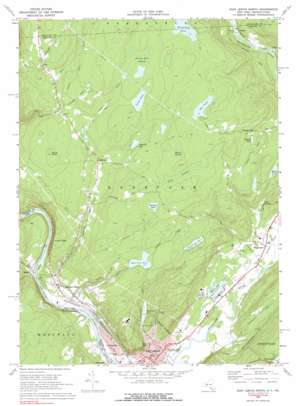
Port Jervis North Topo Map New York
To zoom in, hover over the map of Port Jervis North
USGS Topo Quad 41074d6 - 1:24,000 scale
| Topo Map Name: | Port Jervis North |
| USGS Topo Quad ID: | 41074d6 |
| Print Size: | ca. 21 1/4" wide x 27" high |
| Southeast Coordinates: | 41.375° N latitude / 74.625° W longitude |
| Map Center Coordinates: | 41.4375° N latitude / 74.6875° W longitude |
| U.S. States: | NY, PA |
| Filename: | o41074d6.jpg |
| Download Map JPG Image: | Port Jervis North topo map 1:24,000 scale |
| Map Type: | Topographic |
| Topo Series: | 7.5´ |
| Map Scale: | 1:24,000 |
| Source of Map Images: | United States Geological Survey (USGS) |
| Alternate Map Versions: |
Port Jervis North NY 1942, updated 1958 Download PDF Buy paper map Port Jervis North NY 1942, updated 1959 Download PDF Buy paper map Port Jervis North NY 1969, updated 1972 Download PDF Buy paper map Port Jervis North NY 1969, updated 1977 Download PDF Buy paper map Port Jervis North NY 1969, updated 1990 Download PDF Buy paper map Port Jervis North NY 1992, updated 1994 Download PDF Buy paper map Port Jervis North NY 1997, updated 1999 Download PDF Buy paper map Port Jervis North NY 2010 Download PDF Buy paper map Port Jervis North NY 2013 Download PDF Buy paper map Port Jervis North NY 2016 Download PDF Buy paper map |
1:24,000 Topo Quads surrounding Port Jervis North
> Back to 41074a1 at 1:100,000 scale
> Back to 41074a1 at 1:250,000 scale
> Back to U.S. Topo Maps home
Port Jervis North topo map: Gazetteer
Port Jervis North: Airports
Huguenot Airport (historical) elevation 140m 459′Port Jervis Fire Department Heliport elevation 129m 423′
Port Jervis North: Beaches
West End Beach elevation 131m 429′Port Jervis North: Dams
Mill Rift Pond Dam elevation 167m 547′Port Jervis North: Islands
Cherry Island elevation 134m 439′Port Jervis North: Lakes
Beaverdam Pond elevation 412m 1351′Big Pond elevation 402m 1318′
Boehmler Pond elevation 370m 1213′
Cahoonzie Lake elevation 338m 1108′
Lake Marling elevation 171m 561′
Little Pond elevation 392m 1286′
Sand Pond elevation 259m 849′
Port Jervis North: Parks
Bell Memorial Field elevation 135m 442′Cherry Island State Wildlife Management Area elevation 134m 439′
Childrens Memorial Park elevation 135m 442′
Elks Memorial Park elevation 182m 597′
Orange Square elevation 142m 465′
West End Memorial Park elevation 136m 446′
Port Jervis North: Pillars
Elephants Feet elevation 161m 528′Port Jervis North: Populated Places
Cahoonzie elevation 309m 1013′Germantown elevation 136m 446′
Highridge Estates Mobile Home Park elevation 140m 459′
Huguenot elevation 143m 469′
Lakewood Estates Mobile Home Park elevation 136m 446′
Millrift elevation 141m 462′
Paradise elevation 201m 659′
Port Jervis elevation 136m 446′
Prospect Hill elevation 322m 1056′
Sparrow Bush elevation 155m 508′
Port Jervis North: Reservoirs
Martin Lake elevation 133m 436′McAlister Lake elevation 244m 800′
Prospect Lake elevation 304m 997′
Reservoir Number One elevation 175m 574′
Reservoir Number Three elevation 311m 1020′
Reservoir Number Two elevation 304m 997′
Port Jervis North: Streams
Bush Kill elevation 135m 442′Shingle Kill elevation 134m 439′
Steeny Kill elevation 346m 1135′
Port Jervis North: Summits
Buck Knoll elevation 417m 1368′Hawks Nest elevation 305m 1000′
Point Peter elevation 256m 839′
Port Jervis North: Swamps
Long Swamp elevation 395m 1295′Round Swamp elevation 406m 1332′
Steeny Kill Swamp elevation 406m 1332′
Port Jervis North: Trails
Peenpack Trail elevation 350m 1148′Port Jervis North digital topo map on disk
Buy this Port Jervis North topo map showing relief, roads, GPS coordinates and other geographical features, as a high-resolution digital map file on DVD:
New York, Vermont, Connecticut & Western Massachusetts
Buy digital topo maps: New York, Vermont, Connecticut & Western Massachusetts


