Newburgh Topo Map New York
To zoom in, hover over the map of Newburgh
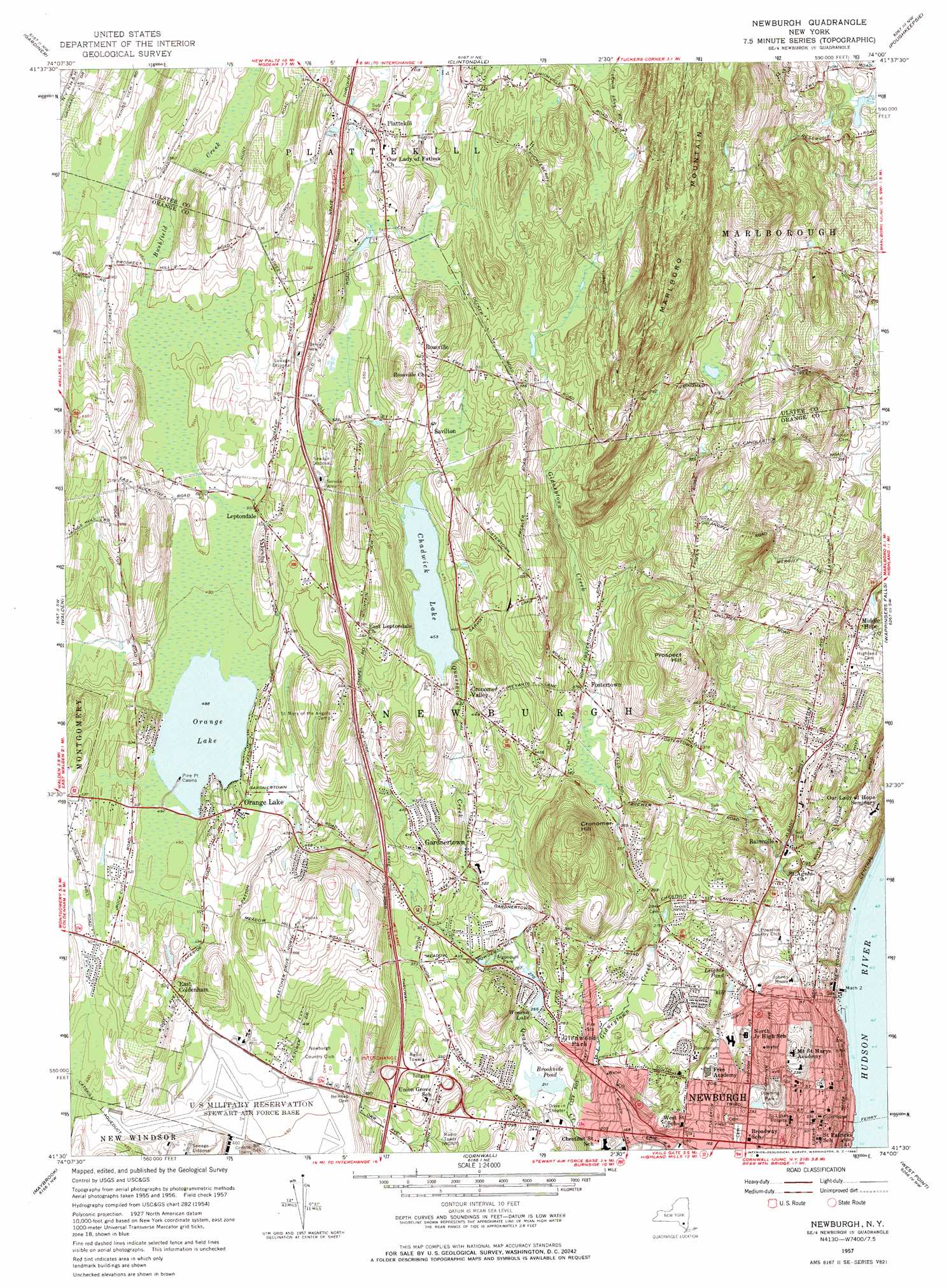
USGS Topo Quad 41074e1 - 1:24,000 scale
| Topo Map Name: | Newburgh |
| USGS Topo Quad ID: | 41074e1 |
| Print Size: | ca. 21 1/4" wide x 27" high |
| Southeast Coordinates: | 41.5° N latitude / 74° W longitude |
| Map Center Coordinates: | 41.5625° N latitude / 74.0625° W longitude |
| U.S. State: | NY |
| Filename: | o41074e1.jpg |
| Download Map JPG Image: | Newburgh topo map 1:24,000 scale |
| Map Type: | Topographic |
| Topo Series: | 7.5´ |
| Map Scale: | 1:24,000 |
| Source of Map Images: | United States Geological Survey (USGS) |
| Alternate Map Versions: |
Newburgh North NY 1947 Download PDF Buy paper map Newburgh NY 1957, updated 1959 Download PDF Buy paper map Newburgh NY 1957, updated 1968 Download PDF Buy paper map Newburgh NY 1957, updated 1968 Download PDF Buy paper map Newburgh NY 1957, updated 1968 Download PDF Buy paper map Newburgh NY 2010 Download PDF Buy paper map Newburgh NY 2013 Download PDF Buy paper map Newburgh NY 2016 Download PDF Buy paper map |
1:24,000 Topo Quads surrounding Newburgh
Kerhonkson |
Mohonk Lake |
Rosendale |
Hyde Park |
Salt Point |
Napanoch |
Gardiner |
Clintondale |
Poughkeepsie |
Pleasant Valley |
Pine Bush |
Walden |
Newburgh |
Wappingers Falls |
Hopewell Junction |
Goshen |
Maybrook |
Cornwall |
West Point |
Oscawana Lake |
Warwick |
Monroe |
Popolopen Lake |
Peekskill |
Mohegan Lake |
> Back to 41074e1 at 1:100,000 scale
> Back to 41074a1 at 1:250,000 scale
> Back to U.S. Topo Maps home
Newburgh topo map: Gazetteer
Newburgh: Airports
Middle Hope Airport elevation 138m 452′Stewart International Airport elevation 141m 462′
Newburgh: Crossings
Exit 7 elevation 110m 360′Exit 8 elevation 86m 282′
Interchange 17 elevation 116m 380′
Newburgh And Beacon Ferry elevation 0m 0′
Newburgh: Lakes
Brookside Pond elevation 64m 209′Chadwick Lake elevation 138m 452′
Leighfs Pond elevation 64m 209′
Orange Lake elevation 148m 485′
Winona Lake elevation 81m 265′
Newburgh: Parks
Algonquin Park elevation 85m 278′Chadwick Lake Park elevation 140m 459′
Clinton Square elevation 26m 85′
Cronomer Hill County Park elevation 160m 524′
Cronomer Hill Park elevation 85m 278′
Downing Park elevation 89m 291′
Leroy Park elevation 50m 164′
Todd Oval elevation 75m 246′
Newburgh: Populated Places
Balmville elevation 66m 216′Candlestick Mobile Home Park elevation 124m 406′
Chadwick Estates elevation 157m 515′
Cronomer Valley elevation 130m 426′
Dogwood Hills elevation 211m 692′
East Coldenham elevation 154m 505′
Fostertown elevation 115m 377′
Gardnertown elevation 125m 410′
Glenwood Park elevation 86m 282′
Hudson Valley Mobile Home Park elevation 96m 314′
Leptondale elevation 155m 508′
Meadow Winds elevation 148m 485′
Middle Hope elevation 75m 246′
Newburgh elevation 39m 127′
Orange Lake elevation 150m 492′
Plattekill elevation 173m 567′
Rossville elevation 192m 629′
Savilton elevation 157m 515′
Varick Homes elevation 24m 78′
Newburgh: Post Offices
Newburgh Post Office elevation 40m 131′Newburgh: Streams
Bushfield Creek elevation 152m 498′Gidneytown Creek elevation 46m 150′
Newburgh: Summits
Cronomer Hill elevation 220m 721′Prospect Hill elevation 212m 695′
Newburgh digital topo map on disk
Buy this Newburgh topo map showing relief, roads, GPS coordinates and other geographical features, as a high-resolution digital map file on DVD:
New York, Vermont, Connecticut & Western Massachusetts
Buy digital topo maps: New York, Vermont, Connecticut & Western Massachusetts