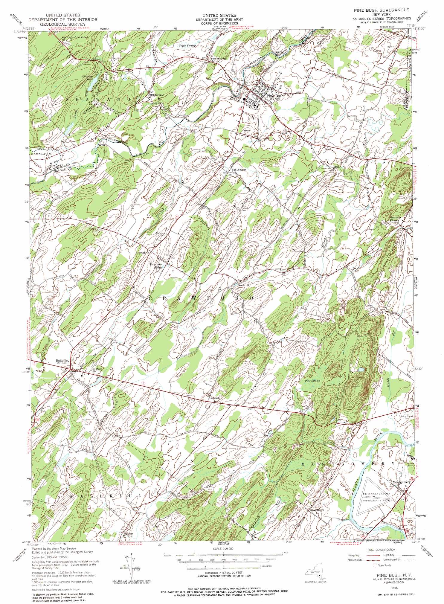
Pine Bush Topo Map New York
To zoom in, hover over the map of Pine Bush
USGS Topo Quad 41074e3 - 1:24,000 scale
| Topo Map Name: | Pine Bush |
| USGS Topo Quad ID: | 41074e3 |
| Print Size: | ca. 21 1/4" wide x 27" high |
| Southeast Coordinates: | 41.5° N latitude / 74.25° W longitude |
| Map Center Coordinates: | 41.5625° N latitude / 74.3125° W longitude |
| U.S. State: | NY |
| Filename: | o41074e3.jpg |
| Download Map JPG Image: | Pine Bush topo map 1:24,000 scale |
| Map Type: | Topographic |
| Topo Series: | 7.5´ |
| Map Scale: | 1:24,000 |
| Source of Map Images: | United States Geological Survey (USGS) |
| Alternate Map Versions: |
Pine Bush NY 1956, updated 1958 Download PDF Buy paper map Pine Bush NY 1956, updated 1965 Download PDF Buy paper map Pine Bush NY 1956, updated 1988 Download PDF Buy paper map Pine Bush NY 2010 Download PDF Buy paper map Pine Bush NY 2013 Download PDF Buy paper map Pine Bush NY 2016 Download PDF Buy paper map |
1:24,000 Topo Quads surrounding Pine Bush
Grahamsville |
Rondout Reservoir |
Kerhonkson |
Mohonk Lake |
Rosendale |
Woodridge |
Ellenville |
Napanoch |
Gardiner |
Clintondale |
Yankee Lake |
Wurtsboro |
Pine Bush |
Walden |
Newburgh |
Otisville |
Middletown |
Goshen |
Maybrook |
Cornwall |
Unionville |
Pine Island |
Warwick |
Monroe |
Popolopen Lake |
> Back to 41074e1 at 1:100,000 scale
> Back to 41074a1 at 1:250,000 scale
> Back to U.S. Topo Maps home
Pine Bush topo map: Gazetteer
Pine Bush: Airports
Orange County Airport elevation 107m 351′Tri-State Airport (historical) elevation 116m 380′
Pine Bush: Bridges
Bodine's Bridge elevation 103m 337′Pine Bush: Lakes
Pinebush Lake elevation 134m 439′Pine Bush: Parks
Crawford Town Park elevation 109m 357′Patrick E Matazara Field elevation 123m 403′
Winding Hills County Park elevation 208m 682′
Pine Bush: Populated Places
Bullville elevation 157m 515′Collabar elevation 180m 590′
Kaisertown elevation 131m 429′
Milburn elevation 154m 505′
Pine Bush elevation 118m 387′
Searsville elevation 146m 479′
Thompson Ridge elevation 139m 456′
Ulsterville elevation 128m 419′
Van Keuren elevation 116m 380′
Pine Bush: Streams
Muddy Kill elevation 104m 341′Pakanasink Creek elevation 97m 318′
Platte Kill elevation 109m 357′
South Branch Pakanasink Creek elevation 161m 528′
Tomy Kill elevation 109m 357′
Verkeerder Kill elevation 101m 331′
Pine Bush: Swamps
Cedar Swamp elevation 126m 413′Pine Swamp elevation 149m 488′
Pine Bush: Trails
Comfort Trail elevation 151m 495′Pine Bush digital topo map on disk
Buy this Pine Bush topo map showing relief, roads, GPS coordinates and other geographical features, as a high-resolution digital map file on DVD:
New York, Vermont, Connecticut & Western Massachusetts
Buy digital topo maps: New York, Vermont, Connecticut & Western Massachusetts