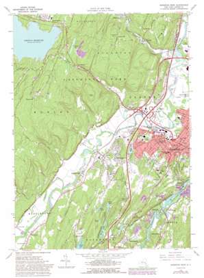
Kingston West Topo Map New York
To zoom in, hover over the map of Kingston West
USGS Topo Quad 41074h1 - 1:24,000 scale
| Topo Map Name: | Kingston West |
| USGS Topo Quad ID: | 41074h1 |
| Print Size: | ca. 21 1/4" wide x 27" high |
| Southeast Coordinates: | 41.875° N latitude / 74° W longitude |
| Map Center Coordinates: | 41.9375° N latitude / 74.0625° W longitude |
| U.S. State: | NY |
| Filename: | o41074h1.jpg |
| Download Map JPG Image: | Kingston West topo map 1:24,000 scale |
| Map Type: | Topographic |
| Topo Series: | 7.5´ |
| Map Scale: | 1:24,000 |
| Source of Map Images: | United States Geological Survey (USGS) |
| Alternate Map Versions: |
Kingston West NY 1942, updated 1950 Download PDF Buy paper map Kingston West NY 1964, updated 1966 Download PDF Buy paper map Kingston West NY 1964, updated 1972 Download PDF Buy paper map Kingston West NY 1964, updated 1989 Download PDF Buy paper map Kingston West NY 1980, updated 1981 Download PDF Buy paper map Kingston West NY 1997, updated 2000 Download PDF Buy paper map Kingston West NY 2010 Download PDF Buy paper map Kingston West NY 2013 Download PDF Buy paper map Kingston West NY 2016 Download PDF Buy paper map |
1:24,000 Topo Quads surrounding Kingston West
> Back to 41074e1 at 1:100,000 scale
> Back to 41074a1 at 1:250,000 scale
> Back to U.S. Topo Maps home
Kingston West topo map: Gazetteer
Kingston West: Airports
Kingston Auxiliary Field (historical) elevation 47m 154′KWP Heliport elevation 184m 603′
Kingston West: Areas
Atkarkaten elevation 56m 183′Kingston West: Crossings
Interchange 19 elevation 49m 160′Kingston West: Islands
Gumaer Island elevation 4m 13′Kingston West: Lakes
Binnewater Lakes elevation 58m 190′DeWitt Lake elevation 29m 95′
First Lake elevation 58m 190′
Fourth Lake elevation 62m 203′
Manor Lake elevation 42m 137′
Onteora Lake elevation 128m 419′
Second Lake elevation 67m 219′
Spring Lake elevation 73m 239′
Third Lake elevation 58m 190′
Twin Lakes elevation 69m 226′
Kingston West: Parks
Dietz Memorial Stadium elevation 54m 177′Forsyth Park elevation 65m 213′
Lawton Park elevation 76m 249′
Senate Park elevation 55m 180′
Kingston West: Populated Places
Bloomington elevation 56m 183′Eddyville elevation 25m 82′
Halihan Hill elevation 134m 439′
Hickorybush elevation 56m 183′
Hillside elevation 97m 318′
Hurley elevation 60m 196′
Jockey Hill elevation 139m 456′
Marbletown elevation 68m 223′
Morgan Hill elevation 185m 606′
New Salem elevation 18m 59′
Riverside Park elevation 64m 209′
Rolling Meadows elevation 92m 301′
Saint Remy elevation 60m 196′
Sawkill elevation 65m 213′
Stony Hollow elevation 131m 429′
Sweet Meadows elevation 75m 246′
West Hurley elevation 182m 597′
Whiteport elevation 53m 173′
Wilbur elevation 4m 13′
Wiltwyck Gardens elevation 58m 190′
Kingston West: Streams
Saw Kill elevation 37m 121′Stony Creek elevation 55m 180′
Sugarbush Creek elevation 10m 32′
Twaalfskill Brook elevation 4m 13′
Kingston West: Summits
Fly Mountain elevation 99m 324′Gallis Hill elevation 240m 787′
Golden Hill elevation 110m 360′
Halihan Hill elevation 159m 521′
Jockey Hill elevation 177m 580′
Morgan Hill elevation 195m 639′
Pink Hill elevation 144m 472′
Kingston West digital topo map on disk
Buy this Kingston West topo map showing relief, roads, GPS coordinates and other geographical features, as a high-resolution digital map file on DVD:
New York, Vermont, Connecticut & Western Massachusetts
Buy digital topo maps: New York, Vermont, Connecticut & Western Massachusetts


