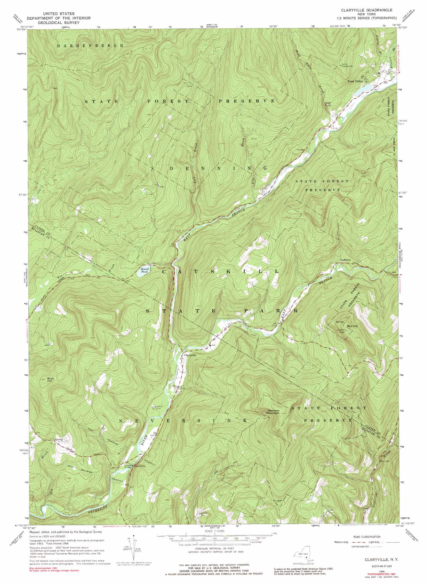
Claryville Topo Map New York
To zoom in, hover over the map of Claryville
USGS Topo Quad 41074h5 - 1:24,000 scale
| Topo Map Name: | Claryville |
| USGS Topo Quad ID: | 41074h5 |
| Print Size: | ca. 21 1/4" wide x 27" high |
| Southeast Coordinates: | 41.875° N latitude / 74.5° W longitude |
| Map Center Coordinates: | 41.9375° N latitude / 74.5625° W longitude |
| U.S. State: | NY |
| Filename: | o41074h5.jpg |
| Download Map JPG Image: | Claryville topo map 1:24,000 scale |
| Map Type: | Topographic |
| Topo Series: | 7.5´ |
| Map Scale: | 1:24,000 |
| Source of Map Images: | United States Geological Survey (USGS) |
| Alternate Map Versions: |
Claryville NY 1966, updated 1968 Download PDF Buy paper map Claryville NY 1966, updated 1974 Download PDF Buy paper map Claryville NY 1966, updated 1988 Download PDF Buy paper map Claryville NY 2010 Download PDF Buy paper map Claryville NY 2013 Download PDF Buy paper map Claryville NY 2016 Download PDF Buy paper map |
1:24,000 Topo Quads surrounding Claryville
Andes |
Margaretville |
Fleischmanns |
West Kill |
Lexington |
Lewbeach |
Arena |
Seager |
Shandaken |
Phoenicia |
Livingston Manor |
Willowemoc |
Claryville |
Peekamoose Mountain |
West Shokan |
Liberty West |
Liberty East |
Grahamsville |
Rondout Reservoir |
Kerhonkson |
White Lake |
Monticello |
Woodridge |
Ellenville |
Napanoch |
> Back to 41074e1 at 1:100,000 scale
> Back to 41074a1 at 1:250,000 scale
> Back to U.S. Topo Maps home
Claryville topo map: Gazetteer
Claryville: Bridges
Halls Mills Covered Bridge elevation 463m 1519′Claryville: Canals
East Delaware Aqueduct elevation 558m 1830′Claryville: Falls
High Falls elevation 616m 2020′Claryville: Lakes
Round Pond elevation 594m 1948′Claryville: Populated Places
Claryville elevation 493m 1617′Frost Valley elevation 622m 2040′
Ladleton elevation 576m 1889′
Claryville: Streams
Biscuit Brook elevation 599m 1965′Clear Creek elevation 572m 1876′
Dry Brook elevation 446m 1463′
Dry Creek elevation 661m 2168′
East Branch Neversink River elevation 488m 1601′
East Moor Brook elevation 725m 2378′
Fall Brook elevation 531m 1742′
Flat Brook elevation 548m 1797′
High Falls Brook elevation 573m 1879′
North Shelter Creek elevation 719m 2358′
Pigeon Brook elevation 616m 2020′
Seep Brook elevation 703m 2306′
Shelter Creek elevation 578m 1896′
South Shelter Creek elevation 719m 2358′
West Branch Neversink River elevation 488m 1601′
West Dry Creek elevation 712m 2335′
West Moor Brook elevation 721m 2365′
Claryville: Summits
Blue Hill elevation 838m 2749′Denman Mountain elevation 929m 3047′
Red Hill elevation 910m 2985′
Claryville digital topo map on disk
Buy this Claryville topo map showing relief, roads, GPS coordinates and other geographical features, as a high-resolution digital map file on DVD:
New York, Vermont, Connecticut & Western Massachusetts
Buy digital topo maps: New York, Vermont, Connecticut & Western Massachusetts