Pecks Pond Topo Map Pennsylvania
To zoom in, hover over the map of Pecks Pond
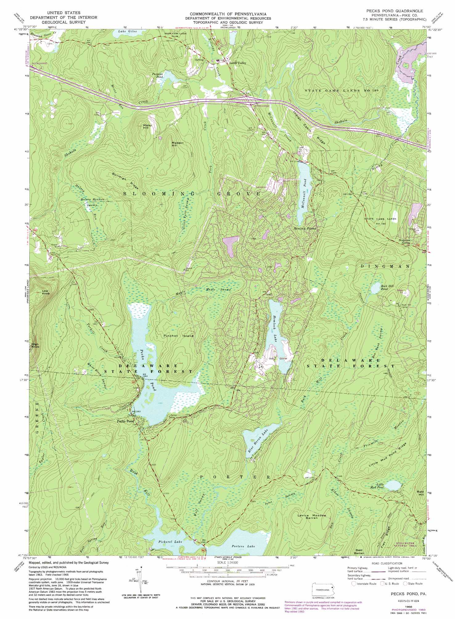
USGS Topo Quad 41075c1 - 1:24,000 scale
| Topo Map Name: | Pecks Pond |
| USGS Topo Quad ID: | 41075c1 |
| Print Size: | ca. 21 1/4" wide x 27" high |
| Southeast Coordinates: | 41.25° N latitude / 75° W longitude |
| Map Center Coordinates: | 41.3125° N latitude / 75.0625° W longitude |
| U.S. State: | PA |
| Filename: | o41075c1.jpg |
| Download Map JPG Image: | Pecks Pond topo map 1:24,000 scale |
| Map Type: | Topographic |
| Topo Series: | 7.5´ |
| Map Scale: | 1:24,000 |
| Source of Map Images: | United States Geological Survey (USGS) |
| Alternate Map Versions: |
Pecks Pond PA 1966, updated 1968 Download PDF Buy paper map Pecks Pond PA 1966, updated 1974 Download PDF Buy paper map Pecks Pond PA 1966, updated 1984 Download PDF Buy paper map Pecks Pond PA 1992, updated 1995 Download PDF Buy paper map Pecks Pond PA 1997, updated 1999 Download PDF Buy paper map Pecks Pond PA 2010 Download PDF Buy paper map Pecks Pond PA 2013 Download PDF Buy paper map Pecks Pond PA 2016 Download PDF Buy paper map |
1:24,000 Topo Quads surrounding Pecks Pond
Honesdale |
White Mills |
Narrowsburg |
Eldred |
Highland Lake |
Lakeville |
Hawley |
Rowland |
Shohola |
Pond Eddy |
Newfoundland |
Promised Land |
Pecks Pond |
Edgemere |
Milford |
Buck Hill Falls |
Skytop |
Twelvemile Pond |
Lake Maskenozha |
Culvers Gap |
Mount Pocono |
East Stroudsburg |
Bushkill |
Flatbrookville |
Newton West |
> Back to 41075a1 at 1:100,000 scale
> Back to 41074a1 at 1:250,000 scale
> Back to U.S. Topo Maps home
Pecks Pond topo map: Gazetteer
Pecks Pond: Areas
Fivemile Meadow elevation 419m 1374′Pecks Pond Picnic Area elevation 427m 1400′
Tarkill Demonstration Area elevation 448m 1469′
Pecks Pond: Dams
Dorys Dam elevation 405m 1328′Hemlock Lake Dam elevation 438m 1437′
Hemlock Pond Dam elevation 437m 1433′
Lower Hemlock Dam elevation 435m 1427′
McConnell Lake Dam elevation 391m 1282′
Mcconnell Lake Dam elevation 391m 1282′
Pecks Pond Dam elevation 414m 1358′
Pickeral Pond Dam elevation 401m 1315′
Pierson Dam elevation 395m 1295′
Porters Lake Dam elevation 400m 1312′
Westbrook Estate Dam elevation 419m 1374′
Pecks Pond: Flats
Lavice Meadow Barren elevation 423m 1387′Pecks Pond: Islands
Pinchot Island elevation 451m 1479′Pecks Pond: Lakes
Little Mud Pond elevation 409m 1341′Persons Pond elevation 392m 1286′
Rock Hill Pond elevation 428m 1404′
Pecks Pond: Parks
State Game Lands Number 180 elevation 430m 1410′Pecks Pond: Populated Places
Hemlock Farms elevation 413m 1354′Lords Valley elevation 399m 1309′
Pecks Pond elevation 419m 1374′
Pecks Pond: Post Offices
Pecks Pond Post Office (historical) elevation 419m 1374′Pecks Pond: Reservoirs
Blue Heron Lake elevation 405m 1328′Elm Lake elevation 424m 1391′
Hemlock Lake elevation 436m 1430′
Lower Hemlock Lake elevation 435m 1427′
McConnell Pond elevation 390m 1279′
Pecks Pond elevation 415m 1361′
Pickerel Lake elevation 399m 1309′
Porters Lake elevation 400m 1312′
Pecks Pond: Ridges
Burleigh Ridge elevation 489m 1604′Indian Cabin Ridge elevation 427m 1400′
Little Mud Pond Ridge elevation 440m 1443′
Pecks Pond: Springs
Dingman Spring elevation 432m 1417′Pecks Pond: Streams
Billings Creek elevation 390m 1279′Birchy Creek elevation 351m 1151′
Holsey Run elevation 408m 1338′
Maple Creek elevation 418m 1371′
McConnell Creek elevation 383m 1256′
Mount Run elevation 399m 1309′
Rock Hill Creek elevation 400m 1312′
Tarkill Creek elevation 417m 1368′
York Creek elevation 392m 1286′
Pecks Pond: Summits
High Knob elevation 624m 2047′Low Knob elevation 607m 1991′
Madden Hill elevation 472m 1548′
Maley Hill elevation 470m 1541′
Rock Hill elevation 402m 1318′
Pecks Pond: Swamps
Ben Bush Swamp elevation 449m 1473′Elbow Swamp elevation 405m 1328′
Holsey Meadow Swamp elevation 424m 1391′
Inlet Swamp elevation 405m 1328′
Little York Swamp elevation 412m 1351′
Maple Swamp elevation 429m 1407′
White Birch Swamp elevation 450m 1476′
Wolf Swamp elevation 402m 1318′
Pecks Pond: Trails
Camp Biff Trail elevation 468m 1535′Flat Ridge Trail elevation 443m 1453′
Kinney Trail elevation 452m 1482′
Smith Trail elevation 428m 1404′
Pecks Pond digital topo map on disk
Buy this Pecks Pond topo map showing relief, roads, GPS coordinates and other geographical features, as a high-resolution digital map file on DVD:
New York, Vermont, Connecticut & Western Massachusetts
Buy digital topo maps: New York, Vermont, Connecticut & Western Massachusetts