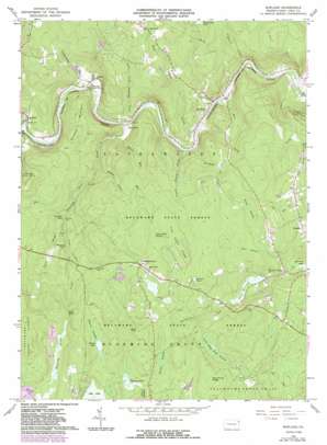
Rowland Topo Map Pennsylvania
To zoom in, hover over the map of Rowland
USGS Topo Quad 41075d1 - 1:24,000 scale
| Topo Map Name: | Rowland |
| USGS Topo Quad ID: | 41075d1 |
| Print Size: | ca. 21 1/4" wide x 27" high |
| Southeast Coordinates: | 41.375° N latitude / 75° W longitude |
| Map Center Coordinates: | 41.4375° N latitude / 75.0625° W longitude |
| U.S. State: | PA |
| Filename: | o41075d1.jpg |
| Download Map JPG Image: | Rowland topo map 1:24,000 scale |
| Map Type: | Topographic |
| Topo Series: | 7.5´ |
| Map Scale: | 1:24,000 |
| Source of Map Images: | United States Geological Survey (USGS) |
| Alternate Map Versions: |
Rowland PA 1966, updated 1967 Download PDF Buy paper map Rowland PA 1966, updated 1974 Download PDF Buy paper map Rowland PA 1966, updated 1983 Download PDF Buy paper map Rowland PA 1966, updated 1984 Download PDF Buy paper map Rowland PA 1999, updated 2001 Download PDF Buy paper map Rowland PA 2010 Download PDF Buy paper map Rowland PA 2013 Download PDF Buy paper map Rowland PA 2016 Download PDF Buy paper map |
1:24,000 Topo Quads surrounding Rowland
> Back to 41075a1 at 1:100,000 scale
> Back to 41074a1 at 1:250,000 scale
> Back to U.S. Topo Maps home
Rowland topo map: Gazetteer
Rowland: Airports
Boehms Field elevation 404m 1325′Rowland: Areas
Owego Picnic Area elevation 405m 1328′Rowland: Dams
Billings Pond Dam elevation 402m 1318′Boehm Dam elevation 327m 1072′
Lake Giles Dam elevation 427m 1400′
Lake Greely Dam elevation 354m 1161′
Pa-455 Dam elevation 352m 1154′
Rowland: Falls
High Falls elevation 407m 1335′Ridgeway Falls elevation 343m 1125′
Rowland: Gaps
Shimers Rock Cut elevation 251m 823′Rowland: Lakes
Beaver Lake elevation 427m 1400′Fourmile Pond elevation 318m 1043′
Killams Pond elevation 407m 1335′
Sylvania Lake elevation 326m 1069′
Rowland: Populated Places
Baoba elevation 247m 810′Bohemia elevation 344m 1128′
Friendly Acres elevation 439m 1440′
Germantown elevation 402m 1318′
Glen Eyre elevation 232m 761′
Kimble elevation 276m 905′
Rowland elevation 211m 692′
Rowland: Reservoirs
Billings Pond elevation 404m 1325′Lake Giles elevation 428m 1404′
Lake Greeley elevation 352m 1154′
Selma Lake elevation 356m 1167′
Rowland: Ridges
Fish Cabin Ridge elevation 441m 1446′Mud Pond Ridge elevation 447m 1466′
Rowland: Streams
Blooming Grove Creek elevation 232m 761′Burchards Creek elevation 360m 1181′
Decker Creek elevation 250m 820′
Grassy Island Creek elevation 218m 715′
Hooper Creek elevation 265m 869′
Kirkham Creek elevation 224m 734′
Little Blooming Grove Creek elevation 223m 731′
Lords Creek elevation 187m 613′
Mill Creek elevation 206m 675′
O'Donnell Creek elevation 199m 652′
Spring Brook elevation 321m 1053′
Steam Mill Run elevation 241m 790′
Taylortown Creek elevation 327m 1072′
Teedyuskung Creek elevation 238m 780′
West Falls Creek elevation 220m 721′
Rowland: Summits
Bald Hill elevation 476m 1561′Shimers Mountain elevation 382m 1253′
Rowland: Swamps
Bear Swamp elevation 400m 1312′Beaver Swamp elevation 431m 1414′
Koski Swamp elevation 383m 1256′
Little Mud Pond Swamp elevation 395m 1295′
Smiths Swamp elevation 401m 1315′
Steam Mill Swamp elevation 429m 1407′
Rowland: Trails
Crawford Trail elevation 451m 1479′Steam Mill Trail elevation 415m 1361′
Rowland digital topo map on disk
Buy this Rowland topo map showing relief, roads, GPS coordinates and other geographical features, as a high-resolution digital map file on DVD:
New York, Vermont, Connecticut & Western Massachusetts
Buy digital topo maps: New York, Vermont, Connecticut & Western Massachusetts


