Lake Ariel Topo Map Pennsylvania
To zoom in, hover over the map of Lake Ariel
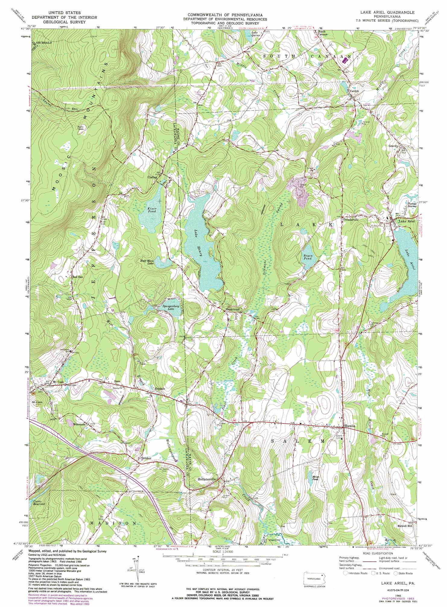
USGS Topo Quad 41075d4 - 1:24,000 scale
| Topo Map Name: | Lake Ariel |
| USGS Topo Quad ID: | 41075d4 |
| Print Size: | ca. 21 1/4" wide x 27" high |
| Southeast Coordinates: | 41.375° N latitude / 75.375° W longitude |
| Map Center Coordinates: | 41.4375° N latitude / 75.4375° W longitude |
| U.S. State: | PA |
| Filename: | o41075d4.jpg |
| Download Map JPG Image: | Lake Ariel topo map 1:24,000 scale |
| Map Type: | Topographic |
| Topo Series: | 7.5´ |
| Map Scale: | 1:24,000 |
| Source of Map Images: | United States Geological Survey (USGS) |
| Alternate Map Versions: |
Lake Ariel PA 1966, updated 1967 Download PDF Buy paper map Lake Ariel PA 1966, updated 1974 Download PDF Buy paper map Lake Ariel PA 1966, updated 1984 Download PDF Buy paper map Lake Ariel PA 1994, updated 1995 Download PDF Buy paper map Lake Ariel PA 2010 Download PDF Buy paper map Lake Ariel PA 2013 Download PDF Buy paper map Lake Ariel PA 2016 Download PDF Buy paper map |
1:24,000 Topo Quads surrounding Lake Ariel
Lenoxville |
Clifford |
Forest City |
Aldenville |
Galilee |
Dalton |
Carbondale |
Waymart |
Honesdale |
White Mills |
Scranton |
Olyphant |
Lake Ariel |
Lakeville |
Hawley |
Avoca |
Moscow |
Sterling |
Newfoundland |
Promised Land |
Pleasant View Summit |
Thornhurst |
Tobyhanna |
Buck Hill Falls |
Skytop |
> Back to 41075a1 at 1:100,000 scale
> Back to 41074a1 at 1:250,000 scale
> Back to U.S. Topo Maps home
Lake Ariel topo map: Gazetteer
Lake Ariel: Dams
Beyea Pond Dam elevation 455m 1492′Coccordrilli Dam elevation 453m 1486′
Kizer Pond Dam elevation 468m 1535′
Labar Dam elevation 440m 1443′
Lake Henry Dam elevation 454m 1489′
Mill Pond Dam elevation 387m 1269′
Shaffer Power Dam elevation 377m 1236′
Lake Ariel: Lakes
Lake Ariel elevation 434m 1423′Meigs Pond elevation 446m 1463′
Lake Ariel: Parks
Varden Conservation Area elevation 382m 1253′Lake Ariel: Populated Places
Bidwell Hill elevation 450m 1476′Cortez elevation 474m 1555′
Drinker elevation 439m 1440′
Elmdale elevation 445m 1459′
Gravity elevation 459m 1505′
Hamlin elevation 478m 1568′
Hollisterville elevation 430m 1410′
Lake Ariel elevation 439m 1440′
Maplewood elevation 450m 1476′
Mount Cobb elevation 507m 1663′
Red Oak elevation 507m 1663′
Saco elevation 483m 1584′
Tresslarville elevation 469m 1538′
Varden elevation 377m 1236′
Wallenpaupack Mills elevation 405m 1328′
Wimmers elevation 483m 1584′
Lake Ariel: Reservoirs
Beyea Pond elevation 455m 1492′Half Moon Lake elevation 467m 1532′
Kizer Pond elevation 469m 1538′
Kizers Little Lake elevation 471m 1545′
Lake Henry elevation 453m 1486′
Spangenberg Lake elevation 465m 1525′
Lake Ariel: Streams
Jones Creek elevation 402m 1318′Moss Hollow Creek elevation 389m 1276′
Wilcox Creek elevation 394m 1292′
Lake Ariel: Summits
Mount Cobb elevation 555m 1820′Lake Ariel: Swamps
Silkmans Swamp elevation 417m 1368′Tisdale Swamp elevation 438m 1437′
Lake Ariel digital topo map on disk
Buy this Lake Ariel topo map showing relief, roads, GPS coordinates and other geographical features, as a high-resolution digital map file on DVD:
New York, Vermont, Connecticut & Western Massachusetts
Buy digital topo maps: New York, Vermont, Connecticut & Western Massachusetts