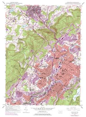
Scranton Topo Map Pennsylvania
To zoom in, hover over the map of Scranton
USGS Topo Quad 41075d6 - 1:24,000 scale
| Topo Map Name: | Scranton |
| USGS Topo Quad ID: | 41075d6 |
| Print Size: | ca. 21 1/4" wide x 27" high |
| Southeast Coordinates: | 41.375° N latitude / 75.625° W longitude |
| Map Center Coordinates: | 41.4375° N latitude / 75.6875° W longitude |
| U.S. State: | PA |
| Filename: | o41075d6.jpg |
| Download Map JPG Image: | Scranton topo map 1:24,000 scale |
| Map Type: | Topographic |
| Topo Series: | 7.5´ |
| Map Scale: | 1:24,000 |
| Source of Map Images: | United States Geological Survey (USGS) |
| Alternate Map Versions: |
Scranton PA 1947, updated 1957 Download PDF Buy paper map Scranton PA 1947, updated 1968 Download PDF Buy paper map Scranton PA 1947, updated 1970 Download PDF Buy paper map Scranton PA 1947, updated 1977 Download PDF Buy paper map Scranton PA 1950 Download PDF Buy paper map Scranton PA 1950 Download PDF Buy paper map Scranton PA 1994, updated 1996 Download PDF Buy paper map Scranton PA 2010 Download PDF Buy paper map Scranton PA 2013 Download PDF Buy paper map Scranton PA 2016 Download PDF Buy paper map |
1:24,000 Topo Quads surrounding Scranton
> Back to 41075a1 at 1:100,000 scale
> Back to 41074a1 at 1:250,000 scale
> Back to U.S. Topo Maps home
Scranton topo map: Gazetteer
Scranton: Airports
Northeast Truck Center Heliport elevation 275m 902′Scranton: Bridges
D and H Green Ridge Bridge elevation 213m 698′Pump Works Bridge elevation 219m 718′
South Side Bridge elevation 202m 662′
Scranton: Crossings
Pennsylvania Turnpike Interchange 38 elevation 374m 1227′Scranton: Dams
Cooling Pond Dam elevation 304m 997′Giovannini Dam elevation 489m 1604′
Griffin Dam elevation 409m 1341′
Interlaken Dam elevation 470m 1541′
Lake Scranton Dam elevation 425m 1394′
Summit Lake Dam elevation 415m 1361′
YMCA Dam elevation 233m 764′
Scranton: Falls
Nay Aug Falls elevation 259m 849′Scranton: Lakes
Cummings Pond elevation 553m 1814′Gravel Pond elevation 360m 1181′
Lance Pond elevation 415m 1361′
Maple Lake elevation 380m 1246′
Scranton: Mines
Archbald Shaft elevation 259m 849′Bellevue Shaft elevation 233m 764′
Biglin Shaft elevation 303m 994′
Bridge Shaft elevation 220m 721′
Brisbin Shaft elevation 268m 879′
Capouse Shaft elevation 256m 839′
Cayuga Shaft elevation 268m 879′
Central Shaft elevation 252m 826′
Chamberlain Shaft elevation 294m 964′
Continental Shaft elevation 282m 925′
Diamond Shaft elevation 225m 738′
Dickson Shaft elevation 226m 741′
Hampton Shaft elevation 238m 780′
Holden Shaft elevation 214m 702′
Hyde Park Shaft elevation 259m 849′
Leggetts Creek Shaft elevation 239m 784′
Manville Shaft elevation 219m 718′
Marvine Shaft elevation 226m 741′
Meadow Brook Shaft elevation 238m 780′
National Shaft elevation 207m 679′
Oxford Shaft elevation 232m 761′
Pine Brook Shaft elevation 219m 718′
Pyne Shaft elevation 267m 875′
Richmond Shaft elevation 256m 839′
Sloan Shaft elevation 226m 741′
Spencer Shaft elevation 317m 1040′
Stafford Shaft elevation 233m 764′
Storrs Shaft elevation 228m 748′
Taylor Shaft elevation 216m 708′
Tripp Shaft elevation 213m 698′
Von Storch Shaft elevation 258m 846′
Scranton: Parks
Anthracite Park elevation 297m 974′Centennial Fountain Saint Ignatius Sculpture elevation 251m 823′
Christ the Teacher Sculpture elevation 242m 793′
Connell Park elevation 305m 1000′
DeNaples Fields elevation 246m 807′
Fitzpatrick Field elevation 233m 764′
Jacob and the Angel Sculpture elevation 261m 856′
Maloney Park elevation 268m 879′
Memorial Commons elevation 280m 918′
Memorial Stadium elevation 212m 695′
Nay Aug Park elevation 298m 977′
Poly-Hi Solidur Park elevation 246m 807′
Robinson Park elevation 421m 1381′
Royal Courts at DeNaples Fields elevation 242m 793′
Schautz Memorial Stadium elevation 299m 980′
Steamtown National Historic Site elevation 209m 685′
Scranton: Populated Places
Austin Heights elevation 232m 761′Chinchilla elevation 353m 1158′
Clarks Green elevation 393m 1289′
Clarks Summit elevation 397m 1302′
Dunmore elevation 295m 967′
Green Ridge elevation 242m 793′
Hyde Park elevation 267m 875′
Keyser Valley elevation 263m 862′
Minooka elevation 274m 898′
Morgan Manor elevation 410m 1345′
Providence elevation 229m 751′
Scranton elevation 230m 754′
Taylor elevation 220m 721′
Scranton: Reservoirs
Capouse Reservoir (historical) elevation 288m 944′Cooling Pond elevation 304m 997′
Griffin Reservoir elevation 411m 1348′
Interlaken Lake elevation 470m 1541′
Lake Scranton elevation 389m 1276′
Mountain Lake elevation 412m 1351′
Summit Lake elevation 421m 1381′
YMCA Dam elevation 233m 764′
Scranton: Streams
Clover Hill Creek elevation 269m 882′Keyser Creek elevation 197m 646′
Leach Creek elevation 238m 780′
Leggetts Creek elevation 217m 711′
Lindy Creek elevation 248m 813′
Lucky Run elevation 236m 774′
Meadow Brook elevation 212m 695′
Mountain Lake Run elevation 246m 807′
Pine Brook (historical) elevation 218m 715′
Roaring Brook elevation 203m 666′
South Branch Leach Creek elevation 326m 1069′
Stafford Meadow Brook elevation 207m 679′
Summit Lake Creek elevation 323m 1059′
Scranton: Summits
Bald Mountain elevation 641m 2103′Bell Mountain elevation 606m 1988′
West Mountain elevation 659m 2162′
Scranton: Swamps
Corby Swamp elevation 390m 1279′Scranton: Tunnels
Clark Tunnel elevation 265m 869′Scranton: Valleys
Nay Aug Park Gorge elevation 261m 856′Scranton digital topo map on disk
Buy this Scranton topo map showing relief, roads, GPS coordinates and other geographical features, as a high-resolution digital map file on DVD:
New York, Vermont, Connecticut & Western Massachusetts
Buy digital topo maps: New York, Vermont, Connecticut & Western Massachusetts


