Hop Bottom Topo Map Pennsylvania
To zoom in, hover over the map of Hop Bottom
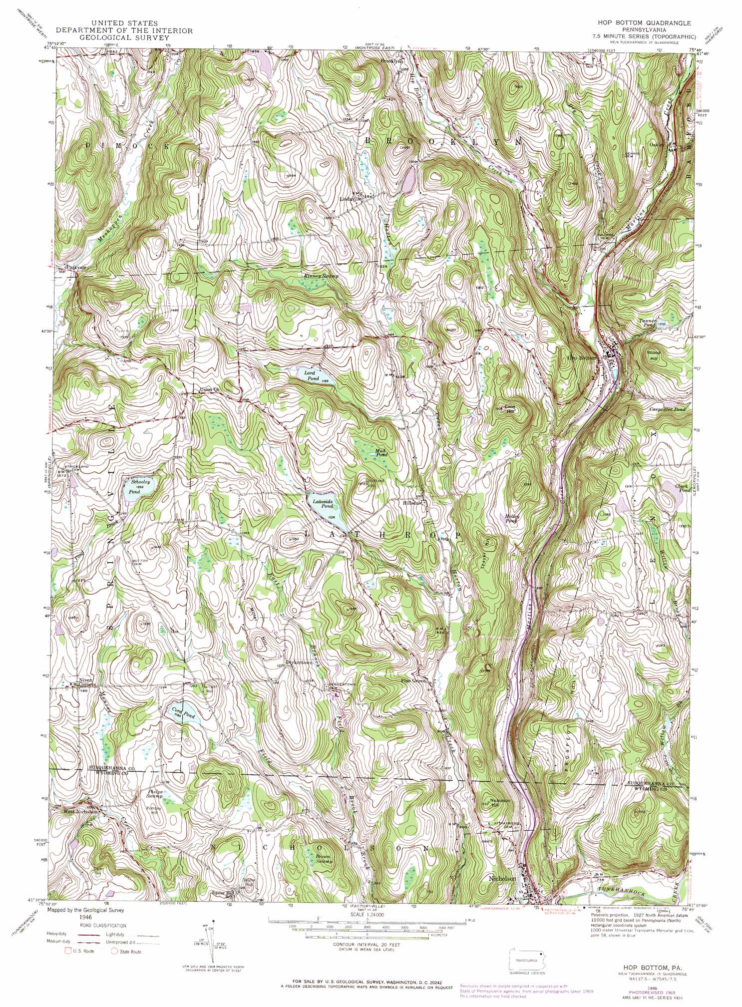
USGS Topo Quad 41075f7 - 1:24,000 scale
| Topo Map Name: | Hop Bottom |
| USGS Topo Quad ID: | 41075f7 |
| Print Size: | ca. 21 1/4" wide x 27" high |
| Southeast Coordinates: | 41.625° N latitude / 75.75° W longitude |
| Map Center Coordinates: | 41.6875° N latitude / 75.8125° W longitude |
| U.S. State: | PA |
| Filename: | o41075f7.jpg |
| Download Map JPG Image: | Hop Bottom topo map 1:24,000 scale |
| Map Type: | Topographic |
| Topo Series: | 7.5´ |
| Map Scale: | 1:24,000 |
| Source of Map Images: | United States Geological Survey (USGS) |
| Alternate Map Versions: |
Hop Bottom PA 1946, updated 1971 Download PDF Buy paper map Hopbottom PA 1947, updated 1947 Download PDF Buy paper map Hop Bottom PA 1994, updated 1995 Download PDF Buy paper map Hop Bottom PA 2010 Download PDF Buy paper map Hop Bottom PA 2013 Download PDF Buy paper map Hop Bottom PA 2016 Download PDF Buy paper map |
1:24,000 Topo Quads surrounding Hop Bottom
Friendsville |
Laurel Lake |
Franklin Forks |
Great Bend |
Susquehanna |
Lawton |
Montrose West |
Montrose East |
Harford |
Thompson |
Auburn Center |
Springville |
Hop Bottom |
Lenoxville |
Clifford |
Meshoppen |
Tunkhannock |
Factoryville |
Dalton |
Carbondale |
Noxen |
Center Moreland |
Ransom |
Scranton |
Olyphant |
> Back to 41075e1 at 1:100,000 scale
> Back to 41074a1 at 1:250,000 scale
> Back to U.S. Topo Maps home
Hop Bottom topo map: Gazetteer
Hop Bottom: Dams
Lakeside Pond Dam elevation 351m 1151′Hop Bottom: Lakes
Carpenter Pond elevation 360m 1181′Clark Pond elevation 397m 1302′
Cord Pond elevation 360m 1181′
Holley Pond elevation 324m 1062′
Lakeside Pond elevation 342m 1122′
Lord Pond elevation 354m 1161′
Mud Pond elevation 374m 1227′
Tanner Pond elevation 370m 1213′
Hop Bottom: Populated Places
Deckertown elevation 364m 1194′Hillsdale elevation 337m 1105′
Hop Bottom elevation 265m 869′
Lindaville elevation 382m 1253′
Nicholson elevation 224m 734′
Oakley elevation 274m 898′
Parkvale elevation 314m 1030′
Pine Grove elevation 284m 931′
West Nicholson elevation 316m 1036′
Hop Bottom: Reservoirs
Schooley Pond elevation 386m 1266′Hop Bottom: Streams
Burdick Creek elevation 311m 1020′Dry Creek elevation 267m 875′
East Branch Field Brook elevation 261m 856′
Hop Bottom Creek elevation 269m 882′
Utley Brook elevation 224m 734′
Hop Bottom: Summits
Coon Hill elevation 435m 1427′Dam Hill elevation 385m 1263′
Miller Hill elevation 405m 1328′
Mulligan Hill elevation 391m 1282′
Nicholson Hill elevation 345m 1131′
Pompey Hill elevation 361m 1184′
Prospect Hill elevation 399m 1309′
Round Hill elevation 443m 1453′
Squire Hill elevation 378m 1240′
Strickland Hill elevation 418m 1371′
Thayer Hill elevation 384m 1259′
Hop Bottom: Swamps
Brown Swamp elevation 338m 1108′Kinney Swamp elevation 372m 1220′
Phelps Swamp elevation 342m 1122′
Hop Bottom digital topo map on disk
Buy this Hop Bottom topo map showing relief, roads, GPS coordinates and other geographical features, as a high-resolution digital map file on DVD:
New York, Vermont, Connecticut & Western Massachusetts
Buy digital topo maps: New York, Vermont, Connecticut & Western Massachusetts