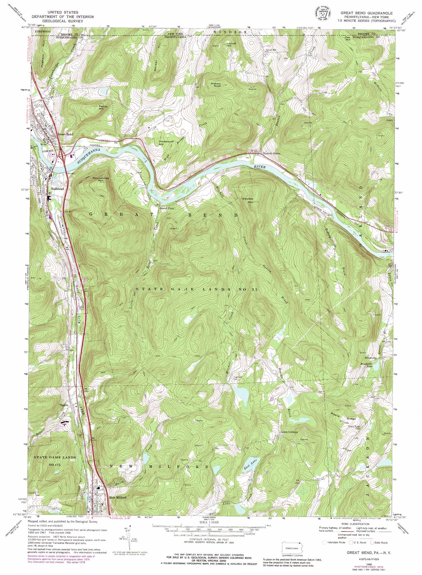
Great Bend Topo Map Pennsylvania
To zoom in, hover over the map of Great Bend
USGS Topo Quad 41075h6 - 1:24,000 scale
| Topo Map Name: | Great Bend |
| USGS Topo Quad ID: | 41075h6 |
| Print Size: | ca. 21 1/4" wide x 27" high |
| Southeast Coordinates: | 41.875° N latitude / 75.625° W longitude |
| Map Center Coordinates: | 41.9375° N latitude / 75.6875° W longitude |
| U.S. States: | PA, NY |
| Filename: | o41075h6.jpg |
| Download Map JPG Image: | Great Bend topo map 1:24,000 scale |
| Map Type: | Topographic |
| Topo Series: | 7.5´ |
| Map Scale: | 1:24,000 |
| Source of Map Images: | United States Geological Survey (USGS) |
| Alternate Map Versions: |
Great Bend PA 1968, updated 1971 Download PDF Buy paper map Great Bend PA 1968, updated 1978 Download PDF Buy paper map Great Bend PA 1968, updated 1986 Download PDF Buy paper map Great Bend PA 1992, updated 1995 Download PDF Buy paper map Great Bend PA 2010 Download PDF Buy paper map Great Bend PA 2013 Download PDF Buy paper map Great Bend PA 2016 Download PDF Buy paper map |
1:24,000 Topo Quads surrounding Great Bend
Castle Creek |
Chenango Forks |
Belden |
Afton |
North Sanford |
Binghamton West |
Binghamton East |
Windsor |
Gulf Summit |
Deposit |
Laurel Lake |
Franklin Forks |
Great Bend |
Susquehanna |
Starrucca |
Montrose West |
Montrose East |
Harford |
Thompson |
Orson |
Springville |
Hop Bottom |
Lenoxville |
Clifford |
Forest City |
> Back to 41075e1 at 1:100,000 scale
> Back to 41074a1 at 1:250,000 scale
> Back to U.S. Topo Maps home
Great Bend topo map: Gazetteer
Great Bend: Airports
Hallstead Airport elevation 268m 879′McKinney Airport elevation 271m 889′
Great Bend: Dams
Dranchak Dam elevation 442m 1450′Fulles Lake Dam elevation 464m 1522′
Great Bend: Islands
Woodbridge Island elevation 268m 879′Great Bend: Parks
State Game Lands Number 175 elevation 409m 1341′State Game Lands Number 35 elevation 516m 1692′
Great Bend: Populated Places
Brushville elevation 414m 1358′Great Bend elevation 272m 892′
Hallstead elevation 265m 869′
Hickory Grove elevation 273m 895′
Island Plain elevation 269m 882′
Lewis Corners elevation 509m 1669′
Tingley elevation 314m 1030′
Great Bend: Reservoirs
Brushville Lake elevation 403m 1322′East Lake elevation 458m 1502′
Fullers Lake elevation 464m 1522′
Great Bend: Ridges
Maple Ridge elevation 565m 1853′Great Bend: Streams
Beaver Creek elevation 305m 1000′Beaver Creek elevation 347m 1138′
Bedbug Brook elevation 263m 862′
Deacon Brook elevation 329m 1079′
Denton Creek elevation 264m 866′
Denton Creek elevation 263m 862′
DuBois Creek elevation 256m 839′
High Bridge Creek elevation 270m 885′
Little Egypt Creek elevation 266m 872′
Meylert Creek elevation 332m 1089′
Mitchell Creek elevation 269m 882′
Salt Lick Creek elevation 256m 839′
Smith Creek elevation 329m 1079′
Great Bend: Summits
Hasbrouck Hill elevation 339m 1112′Hickory Knob elevation 537m 1761′
Hogback Hill elevation 431m 1414′
Kelder Hill elevation 511m 1676′
Locust Hill elevation 523m 1715′
Maunatome Mountain elevation 487m 1597′
Oak Hill elevation 522m 1712′
Penny Hill elevation 455m 1492′
Smokey Mountain elevation 476m 1561′
Great Bend digital topo map on disk
Buy this Great Bend topo map showing relief, roads, GPS coordinates and other geographical features, as a high-resolution digital map file on DVD:
New York, Vermont, Connecticut & Western Massachusetts
Buy digital topo maps: New York, Vermont, Connecticut & Western Massachusetts