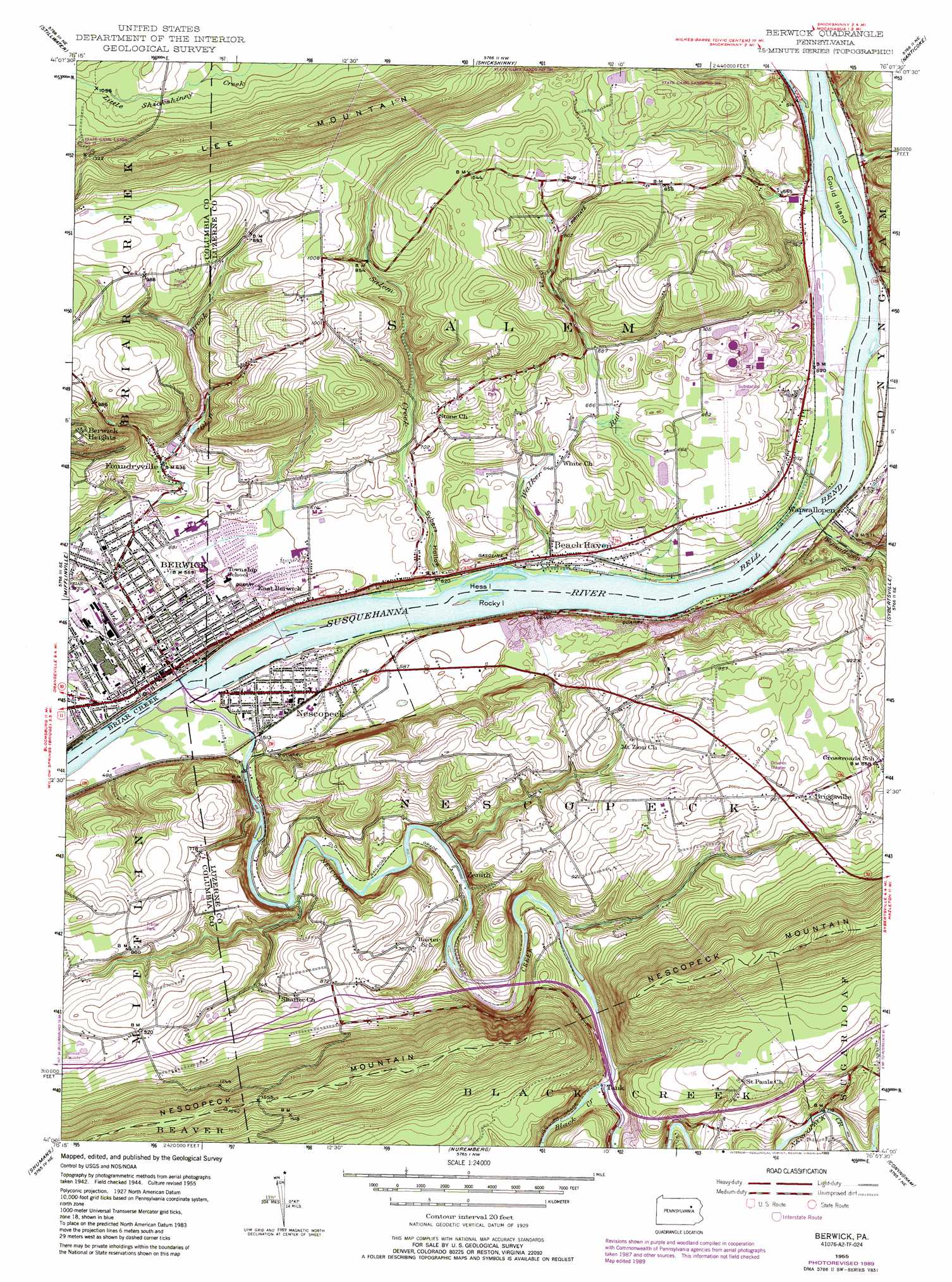
Berwick Topo Map Pennsylvania
To zoom in, hover over the map of Berwick
USGS Topo Quad 41076a2 - 1:24,000 scale
| Topo Map Name: | Berwick |
| USGS Topo Quad ID: | 41076a2 |
| Print Size: | ca. 21 1/4" wide x 27" high |
| Southeast Coordinates: | 41° N latitude / 76.125° W longitude |
| Map Center Coordinates: | 41.0625° N latitude / 76.1875° W longitude |
| U.S. State: | PA |
| Filename: | o41076a2.jpg |
| Download Map JPG Image: | Berwick topo map 1:24,000 scale |
| Map Type: | Topographic |
| Topo Series: | 7.5´ |
| Map Scale: | 1:24,000 |
| Source of Map Images: | United States Geological Survey (USGS) |
| Alternate Map Versions: |
Berwick PA 1955, updated 1956 Download PDF Buy paper map Berwick PA 1955, updated 1968 Download PDF Buy paper map Berwick PA 1955, updated 1971 Download PDF Buy paper map Berwick PA 1955, updated 1978 Download PDF Buy paper map Berwick PA 1955, updated 1989 Download PDF Buy paper map Berwick PA 1955, updated 1989 Download PDF Buy paper map Berwick PA 2010 Download PDF Buy paper map Berwick PA 2013 Download PDF Buy paper map Berwick PA 2016 Download PDF Buy paper map |
1:24,000 Topo Quads surrounding Berwick
Elk Grove |
Red Rock |
Sweet Valley |
Harveys Lake |
Kingston |
Benton |
Stillwater |
Shickshinny |
Nanticoke |
Wilkes-Barre West |
Bloomsburg |
Mifflinville |
Berwick |
Sybertsville |
Freeland |
Catawissa |
Shumans |
Nuremberg |
Conyngham |
Hazleton |
Mount Carmel |
Ashland |
Shenandoah |
Delano |
Tamaqua |
> Back to 41076a1 at 1:100,000 scale
> Back to 41076a1 at 1:250,000 scale
> Back to U.S. Topo Maps home
Berwick topo map: Gazetteer
Berwick: Airports
Berwick Airport elevation 182m 597′Berwick Hospital Corporation Airport elevation 177m 580′
Berwick: Bends
Bell Bend elevation 149m 488′Berwick: Dams
Glen Brook Number Four Dam elevation 228m 748′Berwick: Islands
Gould Island elevation 151m 495′Rocky Island elevation 152m 498′
Berwick: Populated Places
Beach Haven elevation 162m 531′Berwick elevation 170m 557′
Berwick Heights elevation 363m 1190′
Briggsville elevation 298m 977′
East Berwick elevation 178m 583′
Foundryville elevation 194m 636′
Hess Island elevation 152m 498′
Nescopeck elevation 156m 511′
Wapwallopen elevation 165m 541′
Zenith elevation 169m 554′
Berwick: Reservoirs
Glen Brook Reservoir elevation 227m 744′Berwick: Streams
Big Wapwallopen Creek elevation 151m 495′Black Creek elevation 191m 626′
Little Wapwallopen Creek elevation 151m 495′
Nescopeck Creek elevation 146m 479′
Salem Creek elevation 149m 488′
Walker Run elevation 149m 488′
Berwick: Valleys
Sybert Hollow elevation 154m 505′Berwick digital topo map on disk
Buy this Berwick topo map showing relief, roads, GPS coordinates and other geographical features, as a high-resolution digital map file on DVD:
New York, Vermont, Connecticut & Western Massachusetts
Buy digital topo maps: New York, Vermont, Connecticut & Western Massachusetts