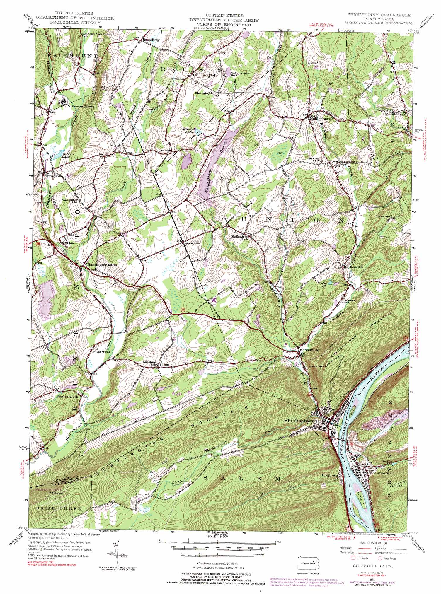
Shickshinny Topo Map Pennsylvania
To zoom in, hover over the map of Shickshinny
USGS Topo Quad 41076b2 - 1:24,000 scale
| Topo Map Name: | Shickshinny |
| USGS Topo Quad ID: | 41076b2 |
| Print Size: | ca. 21 1/4" wide x 27" high |
| Southeast Coordinates: | 41.125° N latitude / 76.125° W longitude |
| Map Center Coordinates: | 41.1875° N latitude / 76.1875° W longitude |
| U.S. State: | PA |
| Filename: | o41076b2.jpg |
| Download Map JPG Image: | Shickshinny topo map 1:24,000 scale |
| Map Type: | Topographic |
| Topo Series: | 7.5´ |
| Map Scale: | 1:24,000 |
| Source of Map Images: | United States Geological Survey (USGS) |
| Alternate Map Versions: |
Shickshinny PA 1954, updated 1955 Download PDF Buy paper map Shickshinny PA 1954, updated 1964 Download PDF Buy paper map Shickshinny PA 1954, updated 1971 Download PDF Buy paper map Shickshinny PA 1954, updated 1978 Download PDF Buy paper map Shickshinny PA 1954, updated 1990 Download PDF Buy paper map Shickshinny PA 2010 Download PDF Buy paper map Shickshinny PA 2013 Download PDF Buy paper map Shickshinny PA 2016 Download PDF Buy paper map |
1:24,000 Topo Quads surrounding Shickshinny
Laporte |
Lopez |
Dutch Mountain |
Noxen |
Center Moreland |
Elk Grove |
Red Rock |
Sweet Valley |
Harveys Lake |
Kingston |
Benton |
Stillwater |
Shickshinny |
Nanticoke |
Wilkes-Barre West |
Bloomsburg |
Mifflinville |
Berwick |
Sybertsville |
Freeland |
Catawissa |
Shumans |
Nuremberg |
Conyngham |
Hazleton |
> Back to 41076a1 at 1:100,000 scale
> Back to 41076a1 at 1:250,000 scale
> Back to U.S. Topo Maps home
Shickshinny topo map: Gazetteer
Shickshinny: Airports
Sutliff Private Airport elevation 314m 1030′Shickshinny: Dams
Hidden Lake Dam elevation 306m 1003′Huntington Mills Paper Mill Dam elevation 245m 803′
Lake Pinecrest Dam elevation 287m 941′
Shickshinny Lake Dam elevation 280m 918′
Shickshinny: Islands
Bellis Island elevation 153m 501′Little Island elevation 152m 498′
Searchs Island elevation 147m 482′
Shickshinny: Lakes
Osborn Culver Pond elevation 342m 1122′Silver Lake elevation 238m 780′
Sorber Pond elevation 260m 853′
Shickshinny: Parks
State Game Lands Number 260 elevation 316m 1036′Shickshinny: Populated Places
Bloomingdale elevation 373m 1223′Broadway elevation 348m 1141′
Dogtown elevation 164m 538′
Harveyville elevation 240m 787′
Huntington Mills elevation 231m 757′
Koonsville elevation 188m 616′
Mocanaqua elevation 169m 554′
Muhlenburg elevation 324m 1062′
Patterson Grove elevation 251m 823′
Pleasant Valley elevation 256m 839′
Shickshinny elevation 157m 515′
Shickshinny: Reservoirs
Hidden Lake elevation 306m 1003′Hiland Lake elevation 323m 1059′
Hillcrest Lake elevation 248m 813′
Lake Pinecrest elevation 287m 941′
Paper Mill Pond elevation 245m 803′
Shickshinny Lake elevation 280m 918′
Shickshinny: Streams
Black Ash Creek elevation 295m 967′Black Creek elevation 147m 482′
Culver Creek elevation 285m 935′
Kitchen Creek elevation 243m 797′
Little Shickshinny Creek elevation 162m 531′
Marsh Creek elevation 296m 971′
Paddy Run elevation 147m 482′
Reyburn Creek elevation 189m 620′
Rocky Run elevation 225m 738′
Rogers Creek elevation 233m 764′
Shickshinny Creek elevation 152m 498′
Turtle Creek elevation 147m 482′
Shickshinny: Summits
Huntington Mountain elevation 499m 1637′Shickshinny Mountain elevation 470m 1541′
Shickshinny: Valleys
Marshall Hollow elevation 244m 800′Nevel Hollow elevation 293m 961′
Shickshinny digital topo map on disk
Buy this Shickshinny topo map showing relief, roads, GPS coordinates and other geographical features, as a high-resolution digital map file on DVD:
New York, Vermont, Connecticut & Western Massachusetts
Buy digital topo maps: New York, Vermont, Connecticut & Western Massachusetts