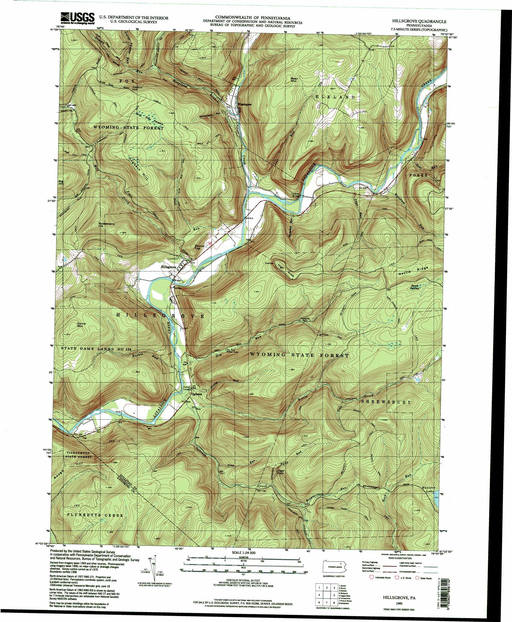
Hillsgrove Topo Map Pennsylvania
To zoom in, hover over the map of Hillsgrove
USGS Topo Quad 41076d6 - 1:24,000 scale
| Topo Map Name: | Hillsgrove |
| USGS Topo Quad ID: | 41076d6 |
| Print Size: | ca. 21 1/4" wide x 27" high |
| Southeast Coordinates: | 41.375° N latitude / 76.625° W longitude |
| Map Center Coordinates: | 41.4375° N latitude / 76.6875° W longitude |
| U.S. State: | PA |
| Filename: | o41076d6.jpg |
| Download Map JPG Image: | Hillsgrove topo map 1:24,000 scale |
| Map Type: | Topographic |
| Topo Series: | 7.5´ |
| Map Scale: | 1:24,000 |
| Source of Map Images: | United States Geological Survey (USGS) |
| Alternate Map Versions: |
Hillsgrove PA 1970, updated 1973 Download PDF Buy paper map Hillsgrove PA 1995, updated 1998 Download PDF Buy paper map Hillsgrove PA 2010 Download PDF Buy paper map Hillsgrove PA 2013 Download PDF Buy paper map Hillsgrove PA 2016 Download PDF Buy paper map |
1:24,000 Topo Quads surrounding Hillsgrove
Gleason |
Canton |
Leroy |
Powell |
Monroeton |
Ralston |
Grover |
Shunk |
Overton |
Dushore |
Bodines |
Barbours |
Hillsgrove |
Eagles Mere |
Laporte |
Montoursville North |
Huntersville |
Picture Rocks |
Sonestown |
Elk Grove |
Montoursville South |
Muncy |
Hughesville |
Lairdsville |
Benton |
> Back to 41076a1 at 1:100,000 scale
> Back to 41076a1 at 1:250,000 scale
> Back to U.S. Topo Maps home
Hillsgrove topo map: Gazetteer
Hillsgrove: Areas
High Knob Natural Area elevation 618m 2027′Kettle Creek Gorge Natural Area elevation 335m 1099′
Hillsgrove: Bridges
High Bridge elevation 387m 1269′Hillsgrove: Falls
Angel Falls elevation 432m 1417′Dry Run Falls elevation 381m 1250′
Hillsgrove: Populated Places
Hillsgrove elevation 266m 872′Hoagland Vista elevation 575m 1886′
Ogdonia elevation 253m 830′
Plunkett elevation 269m 882′
Wissingers elevation 284m 931′
Hillsgrove: Ridges
Nettle Ridge elevation 618m 2027′Hillsgrove: Streams
Barkshed Run elevation 271m 889′Brunnerdale Run elevation 387m 1269′
Cape Run elevation 278m 912′
Dry Run elevation 247m 810′
Elk Creek elevation 261m 856′
Falls Run elevation 357m 1171′
Hoagland Branch elevation 279m 915′
Huckle Run elevation 248m 813′
Joes Run elevation 262m 859′
Ketchum Run elevation 280m 918′
Kettle Creek elevation 255m 836′
Little Swamp Run elevation 374m 1227′
Mill Creek elevation 255m 836′
Ogdonia Creek elevation 243m 797′
Pine Run elevation 300m 984′
Scar Run elevation 287m 941′
Slab Run elevation 266m 872′
Stony Run elevation 243m 797′
Swamp Run elevation 315m 1033′
Hillsgrove: Summits
Bear Mountain elevation 609m 1998′Camp Mountain elevation 586m 1922′
Gooseberry Hill elevation 592m 1942′
High Knob elevation 618m 2027′
Hogback Hill elevation 587m 1925′
Middle Hill elevation 588m 1929′
Rough Hill elevation 525m 1722′
Round Top elevation 373m 1223′
Hillsgrove: Swamps
Slab Run Swamp elevation 558m 1830′Spook Swamp elevation 548m 1797′
Hillsgrove: Trails
Bark Shed Trail elevation 476m 1561′Browns Trail elevation 361m 1184′
Camels Trail elevation 571m 1873′
Camslab Trail elevation 588m 1929′
Dead Horse Trail elevation 459m 1505′
Detters Trail elevation 526m 1725′
East Slab Trail elevation 433m 1420′
Falls Run Trail elevation 428m 1404′
Gooseberry Trail elevation 401m 1315′
Hardwood Trail elevation 499m 1637′
High Knob Trail elevation 496m 1627′
High Landing Trail elevation 568m 1863′
Jackson Trail elevation 529m 1735′
Laurel Ridge Trail elevation 545m 1788′
Middle Hill Trail elevation 537m 1761′
Nettle Ridge Trail elevation 534m 1751′
Old House Trail elevation 508m 1666′
Pole Hill Trail elevation 441m 1446′
Ridge Trail elevation 581m 1906′
Ryans Trail elevation 507m 1663′
Scar Run Trail elevation 445m 1459′
Short Trail elevation 446m 1463′
Stony Run Trail elevation 543m 1781′
Trout Hill Trail elevation 438m 1437′
Walnut Trail elevation 545m 1788′
Hillsgrove: Valleys
Dry Run Gorge elevation 257m 843′Kettle Creek Gorge elevation 265m 869′
Loyalsock Creek Gorge elevation 238m 780′
Painter Hollow elevation 317m 1040′
Warburton Hollow elevation 299m 980′
Hillsgrove digital topo map on disk
Buy this Hillsgrove topo map showing relief, roads, GPS coordinates and other geographical features, as a high-resolution digital map file on DVD:
New York, Vermont, Connecticut & Western Massachusetts
Buy digital topo maps: New York, Vermont, Connecticut & Western Massachusetts