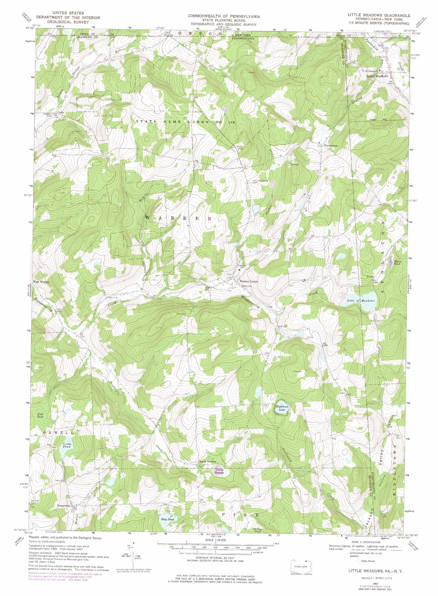
Little Meadows Topo Map Pennsylvania
To zoom in, hover over the map of Little Meadows
USGS Topo Quad 41076h2 - 1:24,000 scale
| Topo Map Name: | Little Meadows |
| USGS Topo Quad ID: | 41076h2 |
| Print Size: | ca. 21 1/4" wide x 27" high |
| Southeast Coordinates: | 41.875° N latitude / 76.125° W longitude |
| Map Center Coordinates: | 41.9375° N latitude / 76.1875° W longitude |
| U.S. States: | PA, NY |
| Filename: | o41076h2.jpg |
| Download Map JPG Image: | Little Meadows topo map 1:24,000 scale |
| Map Type: | Topographic |
| Topo Series: | 7.5´ |
| Map Scale: | 1:24,000 |
| Source of Map Images: | United States Geological Survey (USGS) |
| Alternate Map Versions: |
Little Meadows PA 1967, updated 1971 Download PDF Buy paper map Little Meadows PA 1967, updated 1978 Download PDF Buy paper map Little Meadows PA 1967, updated 1978 Download PDF Buy paper map Little Meadows PA 2010 Download PDF Buy paper map Little Meadows PA 2013 Download PDF Buy paper map Little Meadows PA 2016 Download PDF Buy paper map |
1:24,000 Topo Quads surrounding Little Meadows
Spencer |
Candor |
Newark Valley |
Maine |
Castle Creek |
Barton |
Owego |
Apalachin |
Endicott |
Binghamton West |
Litchfield |
Windham |
Little Meadows |
Friendsville |
Laurel Lake |
Towanda |
Rome |
Le Raysville |
Lawton |
Montrose West |
Monroeton |
Wyalusing |
Laceyville |
Auburn Center |
Springville |
> Back to 41076e1 at 1:100,000 scale
> Back to 41076a1 at 1:250,000 scale
> Back to U.S. Topo Maps home
Little Meadows topo map: Gazetteer
Little Meadows: Dams
Cooks Pond Dam elevation 439m 1440′Little Meadows: Lakes
Lake Of Meadows elevation 464m 1522′Little Meadows: Populated Places
Cadis elevation 350m 1148′Little Meadows elevation 318m 1043′
Nixon elevation 501m 1643′
Potterville elevation 389m 1276′
South Warren elevation 411m 1348′
Warren Center elevation 401m 1315′
Warrenham elevation 418m 1371′
Little Meadows: Reservoirs
Cooks Pond elevation 439m 1440′Haig Pond elevation 435m 1427′
Highland Lake elevation 496m 1627′
Moore Pond elevation 476m 1561′
Little Meadows: Streams
Chaffee Run elevation 363m 1190′Corbin Creek elevation 396m 1299′
Dewing Creek elevation 311m 1020′
Pendleton Creek elevation 337m 1105′
Southwick Creek elevation 333m 1092′
Little Meadows: Swamps
Carey Swamp elevation 421m 1381′Gulf Pond elevation 442m 1450′
Little Meadows digital topo map on disk
Buy this Little Meadows topo map showing relief, roads, GPS coordinates and other geographical features, as a high-resolution digital map file on DVD:
New York, Vermont, Connecticut & Western Massachusetts
Buy digital topo maps: New York, Vermont, Connecticut & Western Massachusetts