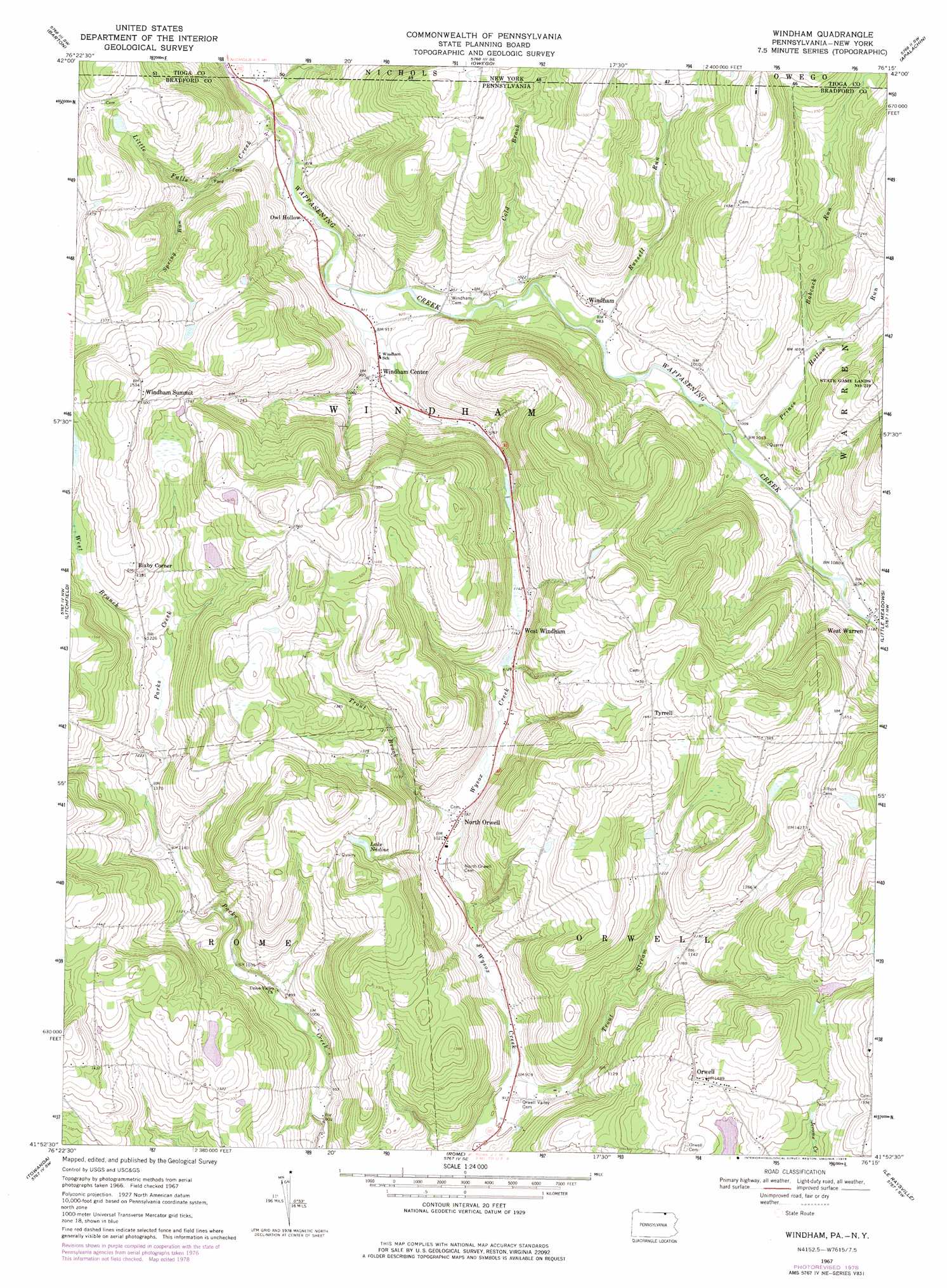
Windham Topo Map Pennsylvania
To zoom in, hover over the map of Windham
USGS Topo Quad 41076h3 - 1:24,000 scale
| Topo Map Name: | Windham |
| USGS Topo Quad ID: | 41076h3 |
| Print Size: | ca. 21 1/4" wide x 27" high |
| Southeast Coordinates: | 41.875° N latitude / 76.25° W longitude |
| Map Center Coordinates: | 41.9375° N latitude / 76.3125° W longitude |
| U.S. States: | PA, NY |
| Filename: | o41076h3.jpg |
| Download Map JPG Image: | Windham topo map 1:24,000 scale |
| Map Type: | Topographic |
| Topo Series: | 7.5´ |
| Map Scale: | 1:24,000 |
| Source of Map Images: | United States Geological Survey (USGS) |
| Alternate Map Versions: |
Windham PA 1967, updated 1971 Download PDF Buy paper map Windham PA 1967, updated 1978 Download PDF Buy paper map Windham PA 2010 Download PDF Buy paper map Windham PA 2013 Download PDF Buy paper map Windham PA 2016 Download PDF Buy paper map |
1:24,000 Topo Quads surrounding Windham
Van Etten |
Spencer |
Candor |
Newark Valley |
Maine |
Waverly |
Barton |
Owego |
Apalachin |
Endicott |
Sayre |
Litchfield |
Windham |
Little Meadows |
Friendsville |
Ulster |
Towanda |
Rome |
Le Raysville |
Lawton |
Powell |
Monroeton |
Wyalusing |
Laceyville |
Auburn Center |
> Back to 41076e1 at 1:100,000 scale
> Back to 41076a1 at 1:250,000 scale
> Back to U.S. Topo Maps home
Windham topo map: Gazetteer
Windham: Lakes
Lake Nadine elevation 421m 1381′Windham: Parks
State Game Lands Number 219 elevation 405m 1328′Windham: Populated Places
Bixby Corner elevation 400m 1312′North Orwell elevation 313m 1026′
Orwell elevation 456m 1496′
Owl Hollow elevation 267m 875′
Russellville elevation 309m 1013′
Tyrrell elevation 444m 1456′
West Warren elevation 341m 1118′
Windham elevation 302m 990′
Windham Center elevation 287m 941′
Windham Summit elevation 457m 1499′
Windham: Streams
Babcock Run elevation 319m 1046′Babcock Run elevation 319m 1046′
Cold Brook elevation 282m 925′
Cold Brook elevation 285m 935′
Little Falls Creek elevation 262m 859′
Prince Hollow Run elevation 306m 1003′
Russell Run elevation 293m 961′
Russell Run elevation 293m 961′
Spring Run elevation 309m 1013′
Trout Brook elevation 317m 1040′
Trout Stream elevation 278m 912′
West Branch Parks Creek elevation 362m 1187′
Windham: Valleys
Briggs Hollow elevation 262m 859′Windham digital topo map on disk
Buy this Windham topo map showing relief, roads, GPS coordinates and other geographical features, as a high-resolution digital map file on DVD:
New York, Vermont, Connecticut & Western Massachusetts
Buy digital topo maps: New York, Vermont, Connecticut & Western Massachusetts