Bentley Creek Topo Map Pennsylvania
To zoom in, hover over the map of Bentley Creek
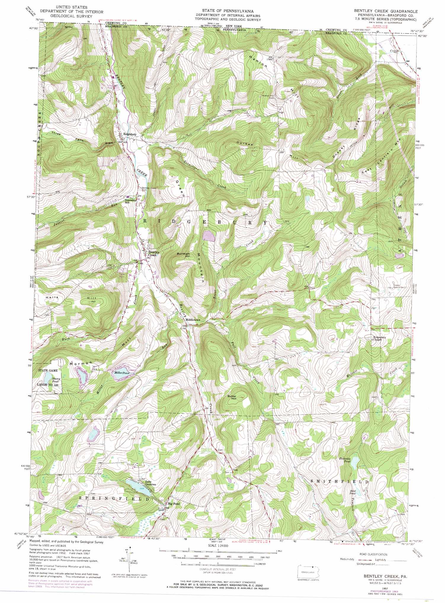
USGS Topo Quad 41076h6 - 1:24,000 scale
| Topo Map Name: | Bentley Creek |
| USGS Topo Quad ID: | 41076h6 |
| Print Size: | ca. 21 1/4" wide x 27" high |
| Southeast Coordinates: | 41.875° N latitude / 76.625° W longitude |
| Map Center Coordinates: | 41.9375° N latitude / 76.6875° W longitude |
| U.S. State: | PA |
| Filename: | o41076h6.jpg |
| Download Map JPG Image: | Bentley Creek topo map 1:24,000 scale |
| Map Type: | Topographic |
| Topo Series: | 7.5´ |
| Map Scale: | 1:24,000 |
| Source of Map Images: | United States Geological Survey (USGS) |
| Alternate Map Versions: |
Bentley Creek PA 1957, updated 1958 Download PDF Buy paper map Bentley Creek PA 1957, updated 1971 Download PDF Buy paper map Bentley Creek PA 1957, updated 1983 Download PDF Buy paper map Bentley Creek PA 1957, updated 1983 Download PDF Buy paper map Bentley Creek PA 2010 Download PDF Buy paper map Bentley Creek PA 2013 Download PDF Buy paper map Bentley Creek PA 2016 Download PDF Buy paper map |
1:24,000 Topo Quads surrounding Bentley Creek
Big Flats |
Horseheads |
Erin |
Van Etten |
Spencer |
Seeley Creek |
Elmira |
Wellsburg |
Waverly |
Barton |
Millerton |
Gillett |
Bentley Creek |
Sayre |
Litchfield |
Roseville |
Troy |
East Troy |
Ulster |
Towanda |
Gleason |
Canton |
Leroy |
Powell |
Monroeton |
> Back to 41076e1 at 1:100,000 scale
> Back to 41076a1 at 1:250,000 scale
> Back to U.S. Topo Maps home
Bentley Creek topo map: Gazetteer
Bentley Creek: Airports
Cole Airport elevation 509m 1669′Bentley Creek: Dams
Galvin Pond Dam elevation 460m 1509′Lake Ondawa Dam elevation 482m 1581′
Millers Pond Dam elevation 427m 1400′
Ridgebury Lake Dam elevation 447m 1466′
Bentley Creek: Lakes
Bird Pond elevation 415m 1361′Stacey Pond elevation 506m 1660′
Bentley Creek: Parks
State Game Lands Number 123 elevation 513m 1683′Bentley Creek: Populated Places
Bentley Creek elevation 320m 1049′Big Pond elevation 442m 1450′
Middletown elevation 351m 1151′
Ridgebury elevation 293m 961′
Bentley Creek: Reservoirs
Blakeslee Pond elevation 421m 1381′Galvin Pond elevation 460m 1509′
Lake Ondawa elevation 476m 1561′
Miller Pond elevation 427m 1400′
Bentley Creek: Ridges
Draper Ridge elevation 478m 1568′Bentley Creek: Streams
Buck Creek elevation 322m 1056′Fall Creek elevation 359m 1177′
Justice Run elevation 305m 1000′
Miller Run elevation 341m 1118′
Terwiliger Creek elevation 292m 958′
Threefall Run elevation 291m 954′
Trout Creek elevation 347m 1138′
Bentley Creek: Summits
Burnham Hill elevation 539m 1768′Butler Hill elevation 529m 1735′
Durkee Hill elevation 548m 1797′
East Canfield Mountain elevation 549m 1801′
Green Mountain elevation 539m 1768′
Halls Hill elevation 538m 1765′
Hanlon Hill elevation 511m 1676′
Mormon Hill elevation 555m 1820′
Bentley Creek: Valleys
Three Falls Glen elevation 306m 1003′Bentley Creek digital topo map on disk
Buy this Bentley Creek topo map showing relief, roads, GPS coordinates and other geographical features, as a high-resolution digital map file on DVD:
New York, Vermont, Connecticut & Western Massachusetts
Buy digital topo maps: New York, Vermont, Connecticut & Western Massachusetts