Snow Shoe Ne Topo Map Pennsylvania
To zoom in, hover over the map of Snow Shoe Ne
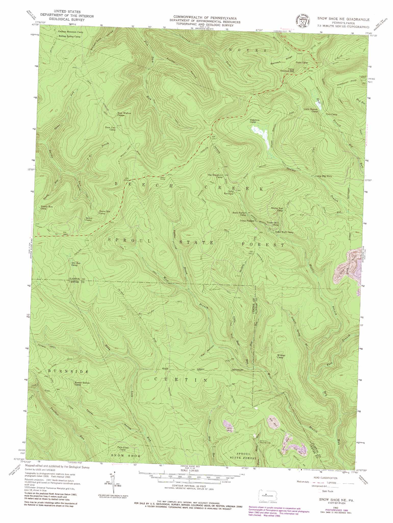
USGS Topo Quad 41077b7 - 1:24,000 scale
| Topo Map Name: | Snow Shoe Ne |
| USGS Topo Quad ID: | 41077b7 |
| Print Size: | ca. 21 1/4" wide x 27" high |
| Southeast Coordinates: | 41.125° N latitude / 77.75° W longitude |
| Map Center Coordinates: | 41.1875° N latitude / 77.8125° W longitude |
| U.S. State: | PA |
| Filename: | o41077b7.jpg |
| Download Map JPG Image: | Snow Shoe Ne topo map 1:24,000 scale |
| Map Type: | Topographic |
| Topo Series: | 7.5´ |
| Map Scale: | 1:24,000 |
| Source of Map Images: | United States Geological Survey (USGS) |
| Alternate Map Versions: |
Snow Shoe NE PA 1960, updated 1962 Download PDF Buy paper map Snow Shoe NE PA 1960, updated 1972 Download PDF Buy paper map Snow Shoe NE PA 1960, updated 1986 Download PDF Buy paper map Snow Shoe NE PA 2010 Download PDF Buy paper map Snow Shoe NE PA 2013 Download PDF Buy paper map Snow Shoe NE PA 2016 Download PDF Buy paper map |
1:24,000 Topo Quads surrounding Snow Shoe Ne
First Fork |
Hammersley Fork |
Tamarack |
Young Womans Creek |
Slate Run |
Sinnemahoning |
Keating |
Renovo West |
Renovo East |
Glen Union |
Pottersdale |
Snow Shoe Nw |
Snow Shoe Ne |
Howard Nw |
Farrandsville |
Karthaus |
Snow Shoe |
Snow Shoe Se |
Howard |
Beech Creek |
Black Moshannon |
Bear Knob |
Bellefonte |
Mingoville |
Madisonburg |
> Back to 41077a1 at 1:100,000 scale
> Back to 41076a1 at 1:250,000 scale
> Back to U.S. Topo Maps home
Snow Shoe Ne topo map: Gazetteer
Snow Shoe Ne: Forests
Sproul State Forest elevation 627m 2057′Snow Shoe Ne: Ridges
Barneys Ridge elevation 711m 2332′Snow Shoe Ne: Streams
Bear Run elevation 384m 1259′Bloody Run elevation 422m 1384′
Coon Run elevation 523m 1715′
East Branch Big Run elevation 350m 1148′
J U Branch elevation 451m 1479′
Little Bear Run elevation 392m 1286′
Middle Branch Big Run elevation 350m 1148′
Packer Fork elevation 371m 1217′
Panther Branch elevation 483m 1584′
Sinking Spring Branch elevation 374m 1227′
West Branch Big Run elevation 295m 967′
Snow Shoe Ne: Trails
Coon Run Trail elevation 572m 1876′Dug Road Trail elevation 594m 1948′
Fish Dam Trail elevation 433m 1420′
Hendricks Trail elevation 553m 1814′
J U Branch Trail elevation 676m 2217′
Little Bear Trail elevation 479m 1571′
Long Trail elevation 554m 1817′
Panther Trail elevation 529m 1735′
Rainbow Trail elevation 609m 1998′
Smiths Run Trail elevation 528m 1732′
Swamp Branch Trail elevation 623m 2043′
Walker Trail elevation 507m 1663′
Weaver Trail elevation 623m 2043′
Snow Shoe Ne: Valleys
Fetzer Hollow elevation 377m 1236′Owl Hollow elevation 431m 1414′
Proctor Hollow elevation 368m 1207′
Snow Shoe Ne digital topo map on disk
Buy this Snow Shoe Ne topo map showing relief, roads, GPS coordinates and other geographical features, as a high-resolution digital map file on DVD:
New York, Vermont, Connecticut & Western Massachusetts
Buy digital topo maps: New York, Vermont, Connecticut & Western Massachusetts