Waterville Topo Map Pennsylvania
To zoom in, hover over the map of Waterville
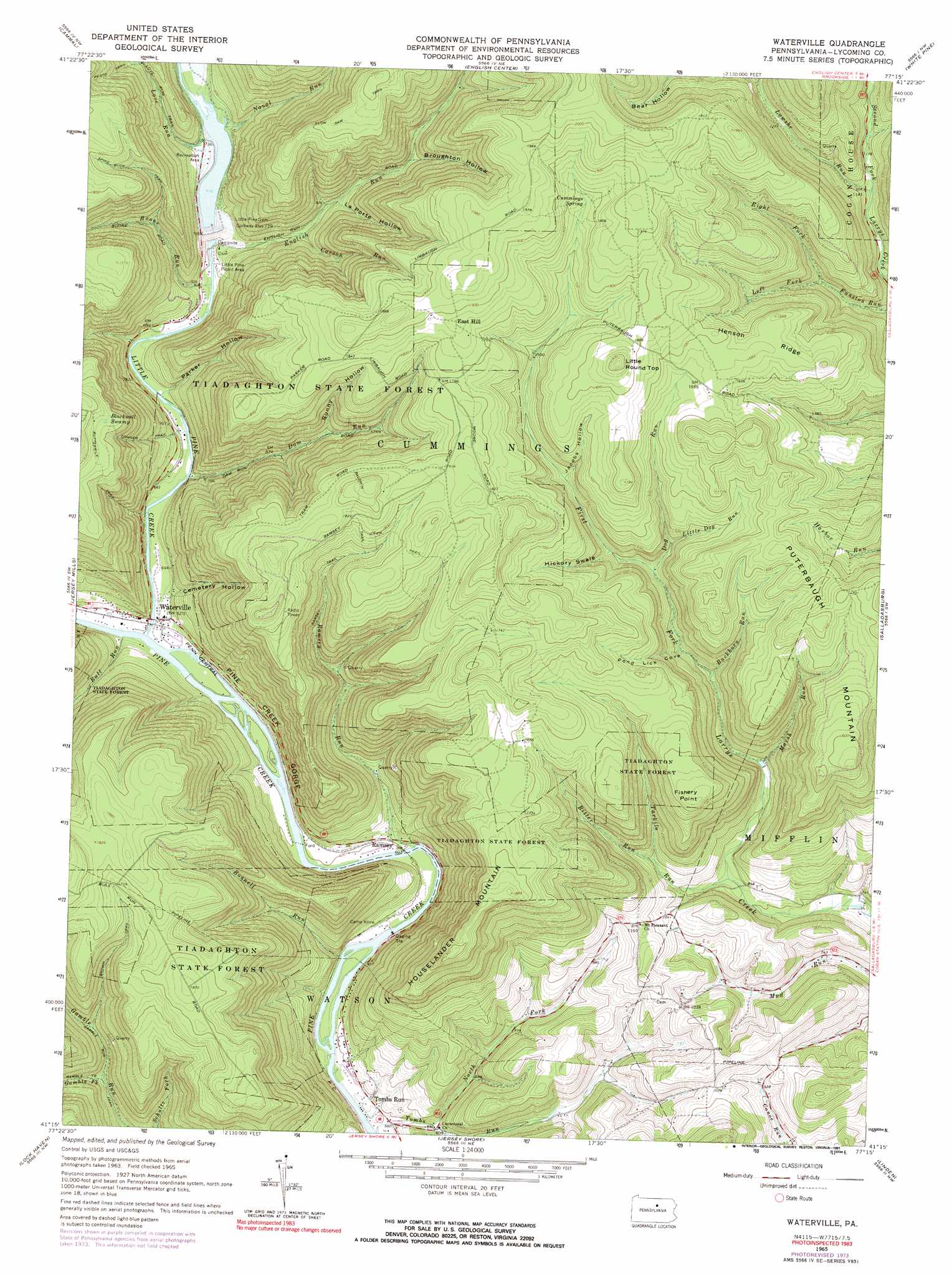
USGS Topo Quad 41077c3 - 1:24,000 scale
| Topo Map Name: | Waterville |
| USGS Topo Quad ID: | 41077c3 |
| Print Size: | ca. 21 1/4" wide x 27" high |
| Southeast Coordinates: | 41.25° N latitude / 77.25° W longitude |
| Map Center Coordinates: | 41.3125° N latitude / 77.3125° W longitude |
| U.S. State: | PA |
| Filename: | o41077c3.jpg |
| Download Map JPG Image: | Waterville topo map 1:24,000 scale |
| Map Type: | Topographic |
| Topo Series: | 7.5´ |
| Map Scale: | 1:24,000 |
| Source of Map Images: | United States Geological Survey (USGS) |
| Alternate Map Versions: |
Waterville PA 1935, updated 1973 Download PDF Buy paper map Waterville PA 1965, updated 1967 Download PDF Buy paper map Waterville PA 1965, updated 1991 Download PDF Buy paper map Waterville PA 1994, updated 1999 Download PDF Buy paper map Waterville PA 2010 Download PDF Buy paper map Waterville PA 2013 Download PDF Buy paper map Waterville PA 2016 Download PDF Buy paper map |
1:24,000 Topo Quads surrounding Waterville
Lee Fire Tower |
Cedar Run |
Morris |
Nauvoo |
Liberty |
Slate Run |
Cammal |
English Center |
White Pine |
Trout Run |
Glen Union |
Jersey Mills |
Waterville |
Salladasburg |
Cogan Station |
Farrandsville |
Lock Haven |
Jersey Shore |
Linden |
Williamsport |
Beech Creek |
Mill Hall |
Loganton |
Carroll |
Williamsport Se |
> Back to 41077a1 at 1:100,000 scale
> Back to 41076a1 at 1:250,000 scale
> Back to U.S. Topo Maps home
Waterville topo map: Gazetteer
Waterville: Cliffs
Fishery Point elevation 543m 1781′Waterville: Dams
Little Pine Dam elevation 240m 787′Waterville: Populated Places
East Hill elevation 570m 1870′English Mills elevation 212m 695′
Ramsey elevation 185m 606′
Tombs Run elevation 178m 583′
Waterville elevation 189m 620′
Waterville: Reservoirs
Little Pine Creek State Park Reservoir elevation 398m 1305′Waterville: Ridges
Henson Ridge elevation 528m 1732′Waterville: Springs
Cummings Spring elevation 538m 1765′Waterville: Streams
Bonnell Run elevation 170m 557′Boone Run elevation 204m 669′
Buckhorn Run elevation 325m 1066′
Bull Run elevation 183m 600′
Bush Run elevation 206m 675′
Buttonwood Run elevation 188m 616′
Carson Run elevation 257m 843′
Dam Run elevation 196m 643′
Dog Run elevation 372m 1220′
English Run elevation 208m 682′
Gamble Fork elevation 281m 921′
Lawshe Run elevation 339m 1112′
Left Fork Funston Run elevation 361m 1184′
Little Dog Run elevation 394m 1292′
Little Pine Creek elevation 183m 600′
Love Run elevation 214m 702′
Marsh Run elevation 289m 948′
Naval Run elevation 221m 725′
North Fork Tombs Run elevation 183m 600′
Ramsey Run elevation 177m 580′
Right Fork Funston Run elevation 361m 1184′
Ritter Run elevation 300m 984′
Tarkiln Run elevation 252m 826′
Tombs Run elevation 166m 544′
Waterville: Summits
Houselander Mountain elevation 589m 1932′Little Round Top elevation 600m 1968′
Puterbaugh Mountain elevation 563m 1847′
Waterville: Swamps
Blackwell Swamp elevation 529m 1735′Waterville: Trails
Baldwin Trail elevation 569m 1866′Bear Path Trail elevation 498m 1633′
Brown Trail elevation 447m 1466′
Clark Hollow Trail elevation 468m 1535′
Conner Trail elevation 307m 1007′
Eagle Trail elevation 483m 1584′
Flow Dam Trail elevation 596m 1955′
Gamble Run Trail elevation 340m 1115′
Naval Trail elevation 291m 954′
Pesto Trail elevation 395m 1295′
Ramsey Trail elevation 441m 1446′
Spike Buck Trail elevation 481m 1578′
Tiadaghton Trail elevation 360m 1181′
Waterville: Valleys
Broughton Hollow elevation 333m 1092′Cemetery Hollow elevation 204m 669′
Cold Spring Hollow elevation 335m 1099′
Hell Hollow elevation 214m 702′
Hickory Swale elevation 399m 1309′
Jacobs Hollow elevation 436m 1430′
La Porte Hollow elevation 281m 921′
Parker Hollow elevation 206m 675′
Pine Creek Gorge elevation 170m 557′
Pond Lick Cove elevation 341m 1118′
Thompson Hollow elevation 359m 1177′
Waterville digital topo map on disk
Buy this Waterville topo map showing relief, roads, GPS coordinates and other geographical features, as a high-resolution digital map file on DVD:
New York, Vermont, Connecticut & Western Massachusetts
Buy digital topo maps: New York, Vermont, Connecticut & Western Massachusetts