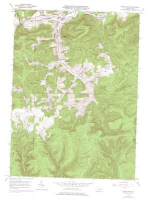
Marshlands Topo Map Pennsylvania
To zoom in, hover over the map of Marshlands
USGS Topo Quad 41077f5 - 1:24,000 scale
| Topo Map Name: | Marshlands |
| USGS Topo Quad ID: | 41077f5 |
| Print Size: | ca. 21 1/4" wide x 27" high |
| Southeast Coordinates: | 41.625° N latitude / 77.5° W longitude |
| Map Center Coordinates: | 41.6875° N latitude / 77.5625° W longitude |
| U.S. State: | PA |
| Filename: | o41077f5.jpg |
| Download Map JPG Image: | Marshlands topo map 1:24,000 scale |
| Map Type: | Topographic |
| Topo Series: | 7.5´ |
| Map Scale: | 1:24,000 |
| Source of Map Images: | United States Geological Survey (USGS) |
| Alternate Map Versions: |
Marshlands PA 1947, updated 1962 Download PDF Buy paper map Marshlands PA 1947, updated 1970 Download PDF Buy paper map Marshlands PA 1947, updated 1972 Download PDF Buy paper map Marshlands PA 1947, updated 1976 Download PDF Buy paper map Marshlands PA 1947, updated 1976 Download PDF Buy paper map Marshlands PA 1950 Download PDF Buy paper map Marshlands PA 2010 Download PDF Buy paper map Marshlands PA 2013 Download PDF Buy paper map Marshlands PA 2016 Download PDF Buy paper map |
1:24,000 Topo Quads surrounding Marshlands
> Back to 41077e1 at 1:100,000 scale
> Back to 41076a1 at 1:250,000 scale
> Back to U.S. Topo Maps home
Marshlands topo map: Gazetteer
Marshlands: Populated Places
Gaines Junction elevation 385m 1263′Manhattan elevation 381m 1250′
Marshlands elevation 420m 1377′
Waltrous elevation 384m 1259′
Marshlands: Post Offices
Elk Run Post Office (historical) elevation 423m 1387′Marshlands: Streams
Babylon Run elevation 443m 1453′Big Spring Brook elevation 555m 1820′
Billings Branch elevation 534m 1751′
Bloody Run elevation 402m 1318′
Chaffee Run elevation 478m 1568′
East Branch Cedar Run elevation 499m 1637′
Elk Run elevation 382m 1253′
Gilbert Run elevation 510m 1673′
Gormania Branch elevation 419m 1374′
Johnson Brook elevation 396m 1299′
Lewis Run elevation 463m 1519′
Lick Run elevation 370m 1213′
Long Run elevation 371m 1217′
Madison Hollow elevation 414m 1358′
Mill Run elevation 564m 1850′
Phoenix Run elevation 387m 1269′
West Branch Cedar Run elevation 499m 1637′
Wetmore Run elevation 450m 1476′
Marshlands: Summits
Cedar Mountain elevation 752m 2467′Elephant Mountain elevation 692m 2270′
Hedgehog Point elevation 656m 2152′
Lick Run Hill elevation 638m 2093′
Marshlands: Trails
Bake Oven Trail elevation 583m 1912′Big Spring Brook Trail elevation 666m 2185′
Billings Trail elevation 545m 1788′
Chestnut Trail elevation 719m 2358′
Dewey Hollow Trail elevation 640m 2099′
First Switchback Trail elevation 530m 1738′
Half Mile Trail elevation 551m 1807′
Johnny McHood Trail elevation 611m 2004′
Long Warrant Trail elevation 641m 2103′
O'Connor Trail elevation 574m 1883′
Water Tank Trail elevation 607m 1991′
Marshlands: Valleys
Bailey Hollow elevation 594m 1948′Benaur Hollow elevation 397m 1302′
Big Hollow elevation 475m 1558′
D A Smith Hollow elevation 421m 1381′
Dead Bear Hollow elevation 538m 1765′
Dead Horse Hollow elevation 625m 2050′
Decker Hollow elevation 372m 1220′
Deer Lick Hollow elevation 412m 1351′
Dewey Hollow elevation 479m 1571′
Dimmick Hollow elevation 557m 1827′
Fegley Hollow elevation 601m 1971′
First Hollow elevation 579m 1899′
Gas Well Hollow elevation 414m 1358′
Grim Hollow elevation 515m 1689′
Gross Hollow elevation 577m 1893′
Hubers Hollow elevation 498m 1633′
Hurlbert Hollow elevation 437m 1433′
John Smith Hollow elevation 428m 1404′
Kohler Hollow elevation 512m 1679′
Madison Hollow elevation 428m 1404′
Maple Hollow elevation 545m 1788′
Maynard Hollow elevation 516m 1692′
McCracker Hollow elevation 450m 1476′
Mitchell Hollow elevation 520m 1706′
Olive Draft elevation 509m 1669′
Parker Hollow elevation 614m 2014′
Reese Hollow elevation 548m 1797′
Schoonover Hollow elevation 523m 1715′
Sease Hollow elevation 478m 1568′
Shaar Hollow elevation 604m 1981′
Shaver Hollow elevation 474m 1555′
Shin Hollow elevation 371m 1217′
Sixth Hollow elevation 556m 1824′
Straitz Hollow elevation 434m 1423′
Swope Hollow elevation 506m 1660′
Third Hollow elevation 576m 1889′
Thompson Hollow elevation 492m 1614′
Tin Can Hollow elevation 519m 1702′
Water Trough Hollow elevation 539m 1768′
Water Trough Hollow elevation 537m 1761′
White Horse Hollow elevation 480m 1574′
Whitney Hollow elevation 384m 1259′
Marshlands digital topo map on disk
Buy this Marshlands topo map showing relief, roads, GPS coordinates and other geographical features, as a high-resolution digital map file on DVD:
New York, Vermont, Connecticut & Western Massachusetts
Buy digital topo maps: New York, Vermont, Connecticut & Western Massachusetts


