Pottersdale Topo Map Pennsylvania
To zoom in, hover over the map of Pottersdale
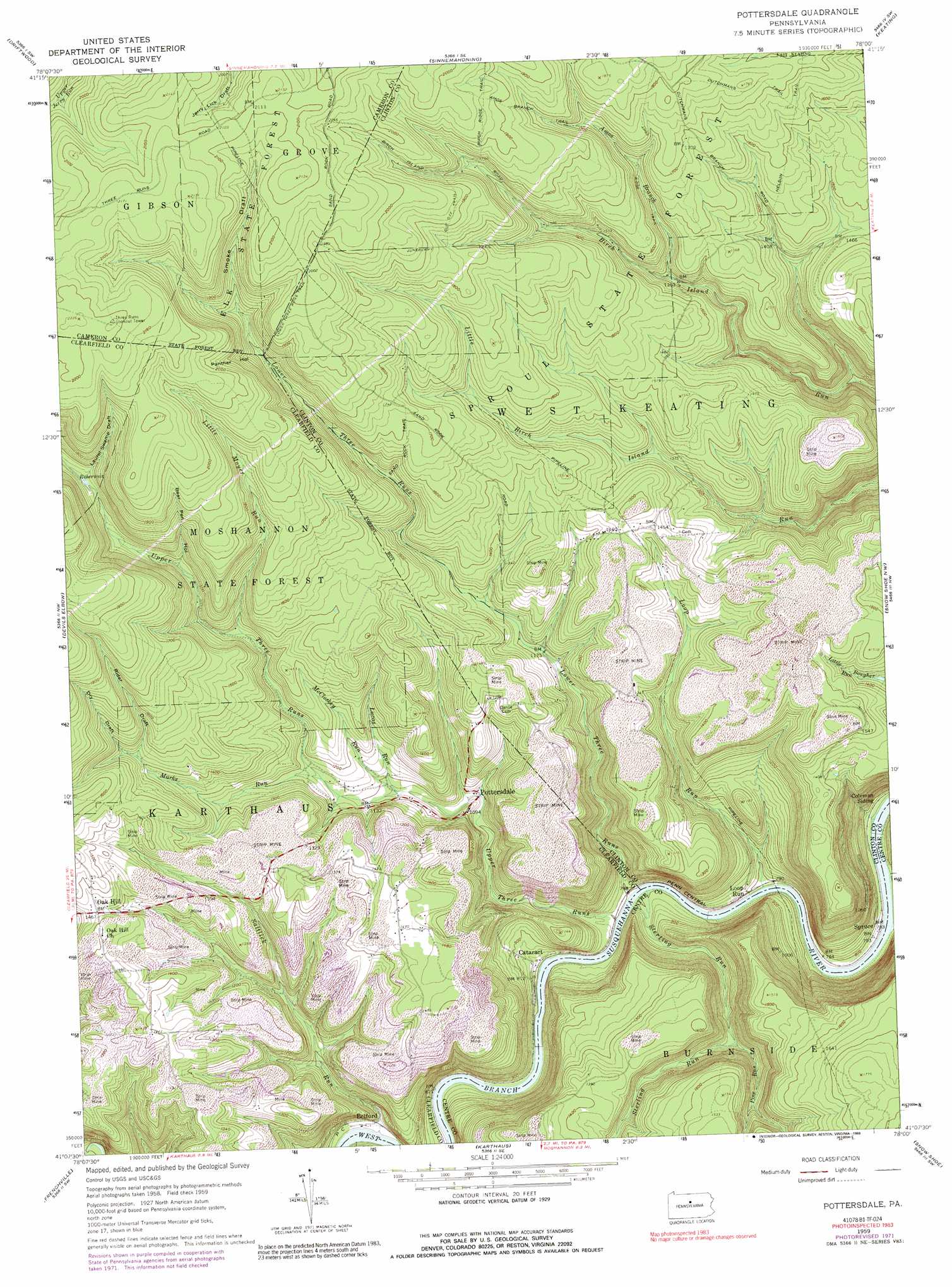
USGS Topo Quad 41078b1 - 1:24,000 scale
| Topo Map Name: | Pottersdale |
| USGS Topo Quad ID: | 41078b1 |
| Print Size: | ca. 21 1/4" wide x 27" high |
| Southeast Coordinates: | 41.125° N latitude / 78° W longitude |
| Map Center Coordinates: | 41.1875° N latitude / 78.0625° W longitude |
| U.S. State: | PA |
| Filename: | o41078b1.jpg |
| Download Map JPG Image: | Pottersdale topo map 1:24,000 scale |
| Map Type: | Topographic |
| Topo Series: | 7.5´ |
| Map Scale: | 1:24,000 |
| Source of Map Images: | United States Geological Survey (USGS) |
| Alternate Map Versions: |
Pottersdale PA 1959, updated 1961 Download PDF Buy paper map Pottersdale PA 1959, updated 1969 Download PDF Buy paper map Pottersdale PA 1959, updated 1972 Download PDF Buy paper map Pottersdale PA 1959, updated 1989 Download PDF Buy paper map Pottersdale PA 2010 Download PDF Buy paper map Pottersdale PA 2013 Download PDF Buy paper map Pottersdale PA 2016 Download PDF Buy paper map |
1:24,000 Topo Quads surrounding Pottersdale
West Creek |
Cameron |
First Fork |
Hammersley Fork |
Tamarack |
Dents Run |
Driftwood |
Sinnemahoning |
Keating |
Renovo West |
The Knobs |
Devils Elbow |
Pottersdale |
Snow Shoe Nw |
Snow Shoe Ne |
Lecontes Mills |
Frenchville |
Karthaus |
Snow Shoe |
Snow Shoe Se |
Wallaceton |
Philipsburg |
Black Moshannon |
Bear Knob |
Bellefonte |
> Back to 41078a1 at 1:100,000 scale
> Back to 41078a1 at 1:250,000 scale
> Back to U.S. Topo Maps home
Pottersdale topo map: Gazetteer
Pottersdale: Dams
J E Hoffman Number Three Mine Refuse Bank Dam elevation 405m 1328′Pottersdale: Mines
Perry Moshannon Mine elevation 467m 1532′Pottersdale: Populated Places
Belford elevation 263m 862′Oak Hill elevation 449m 1473′
Pottersdale elevation 319m 1046′
Spruce elevation 238m 780′
Pottersdale: Streams
Amos Branch elevation 423m 1387′Laurel Swamp Run elevation 498m 1633′
Little Moyer Run elevation 410m 1345′
Loop Run elevation 238m 780′
Lower Three Runs elevation 244m 800′
Lucas Run elevation 329m 1079′
Marks Run elevation 351m 1151′
McCloskey Run elevation 328m 1076′
Pine Run elevation 312m 1023′
Saltlick Run elevation 249m 816′
Sterling Run elevation 242m 793′
Upper Three Runs elevation 241m 790′
Pottersdale: Trails
Amos Branch Trail elevation 547m 1794′Amos Ridge Trail elevation 495m 1624′
Brown Trail elevation 472m 1548′
Cut Off Trail elevation 572m 1876′
Dutchmans Trail elevation 531m 1742′
Juneberry Trail elevation 550m 1804′
Laurel Swamp Trail elevation 658m 2158′
Nelson Trail elevation 481m 1578′
Number Three Trail elevation 653m 2142′
Pottersdale: Valleys
Bear Pen Hollow elevation 447m 1466′Laurel Swamp Draft elevation 497m 1630′
Panther Hollow elevation 523m 1715′
Rider Draft elevation 434m 1423′
Smoke Draft elevation 533m 1748′
Pottersdale digital topo map on disk
Buy this Pottersdale topo map showing relief, roads, GPS coordinates and other geographical features, as a high-resolution digital map file on DVD:
 map DVD")