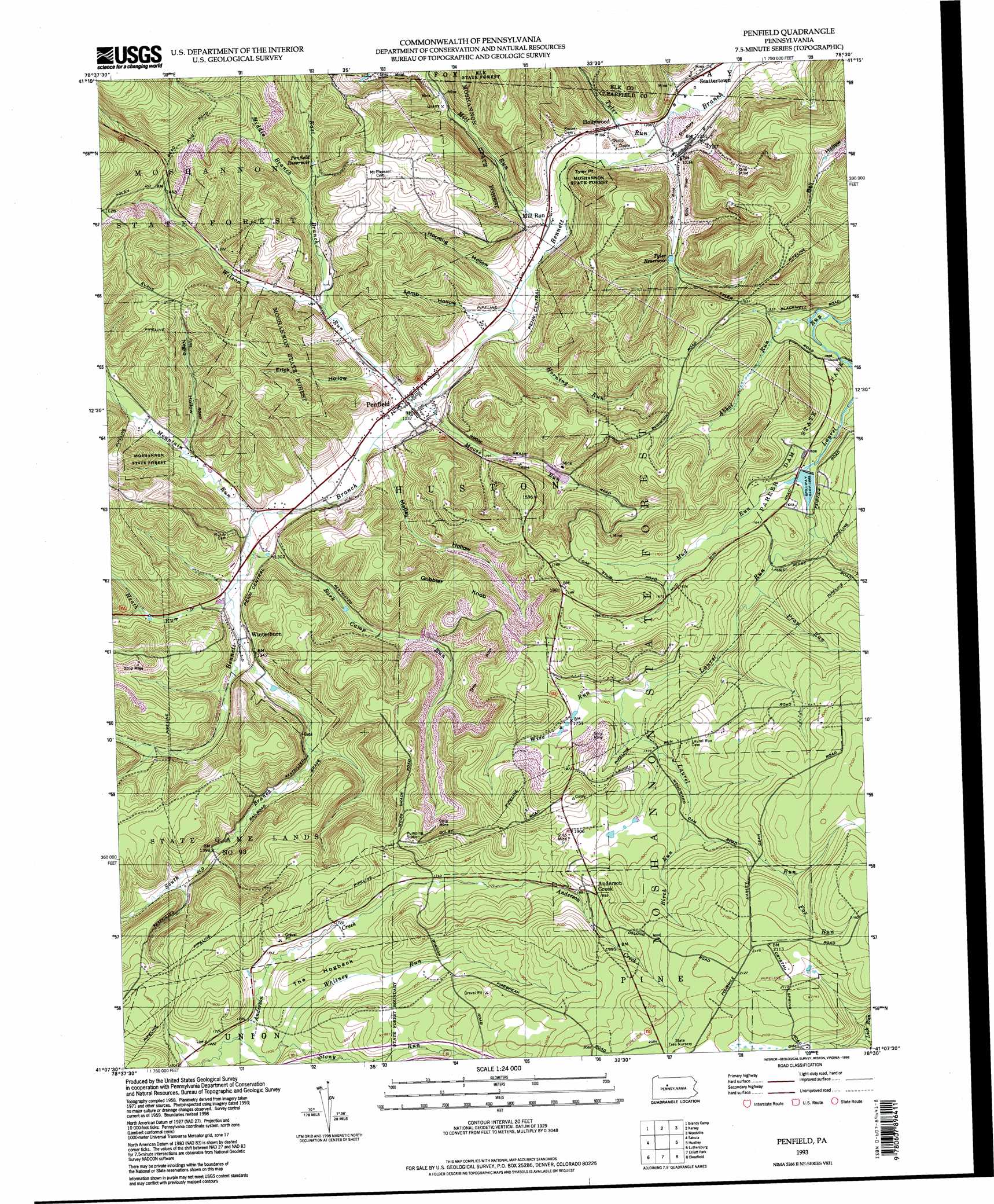
Penfield Topo Map Pennsylvania
To zoom in, hover over the map of Penfield
USGS Topo Quad 41078b5 - 1:24,000 scale
| Topo Map Name: | Penfield |
| USGS Topo Quad ID: | 41078b5 |
| Print Size: | ca. 21 1/4" wide x 27" high |
| Southeast Coordinates: | 41.125° N latitude / 78.5° W longitude |
| Map Center Coordinates: | 41.1875° N latitude / 78.5625° W longitude |
| U.S. State: | PA |
| Filename: | o41078b5.jpg |
| Download Map JPG Image: | Penfield topo map 1:24,000 scale |
| Map Type: | Topographic |
| Topo Series: | 7.5´ |
| Map Scale: | 1:24,000 |
| Source of Map Images: | United States Geological Survey (USGS) |
| Alternate Map Versions: |
Penfield PA 1959, updated 1960 Download PDF Buy paper map Penfield PA 1959, updated 1970 Download PDF Buy paper map Penfield PA 1959, updated 1972 Download PDF Buy paper map Penfield PA 1959, updated 1979 Download PDF Buy paper map Penfield PA 1959, updated 1991 Download PDF Buy paper map Penfield PA 1993, updated 1998 Download PDF Buy paper map Penfield PA 2010 Download PDF Buy paper map Penfield PA 2013 Download PDF Buy paper map Penfield PA 2016 Download PDF Buy paper map |
1:24,000 Topo Quads surrounding Penfield
Portland Mills |
Ridgway |
Saint Marys |
Rathbun |
West Creek |
Carman |
Brandy Camp |
Kersey |
Weedville |
Dents Run |
Falls Creek |
Sabula |
Penfield |
Huntley |
The Knobs |
Du Bois |
Luthersburg |
Elliott Park |
Clearfield |
Lecontes Mills |
Mcgees Mills |
Mahaffey |
Curwensville |
Glen Richey |
Wallaceton |
> Back to 41078a1 at 1:100,000 scale
> Back to 41078a1 at 1:250,000 scale
> Back to U.S. Topo Maps home
Penfield topo map: Gazetteer
Penfield: Capes
Tyler Point elevation 432m 1417′Penfield: Dams
Parker Dam elevation 486m 1594′Parker Dam elevation 485m 1591′
Penfield: Parks
Parker Dam State Park elevation 496m 1627′State Game Lands Number 93 elevation 436m 1430′
Penfield: Populated Places
Anderson Creek elevation 573m 1879′Gobbler Knob elevation 536m 1758′
Hollywood elevation 380m 1246′
Hoovertown elevation 387m 1269′
Mill Run elevation 371m 1217′
Mount Pleasant elevation 506m 1660′
Penfield elevation 382m 1253′
Scattertown elevation 366m 1200′
Tyler elevation 382m 1253′
Winterburn elevation 411m 1348′
Penfield: Reservoirs
Penfield Reservoir elevation 413m 1354′Tyler Reservoir elevation 399m 1309′
Penfield: Streams
Abbot Run elevation 457m 1499′Bark Camp Run elevation 390m 1279′
Birch Run elevation 566m 1856′
East Branch Wilson Run elevation 389m 1276′
Fox Run elevation 600m 1968′
Grapevine Run elevation 407m 1335′
Heath Run elevation 395m 1295′
Horning Run elevation 372m 1220′
Little Laurel Run elevation 489m 1604′
Matley Run elevation 382m 1253′
Middle Branch Wilson Run elevation 407m 1335′
Mill Run elevation 371m 1217′
Moose Run elevation 378m 1240′
Mountain Run elevation 388m 1272′
Mud Run elevation 486m 1594′
Pray Run elevation 503m 1650′
South Branch Bennett Branch elevation 394m 1292′
Stony Run elevation 517m 1696′
Tyler Run elevation 365m 1197′
Whitney Run elevation 518m 1699′
Wilson Run elevation 378m 1240′
Wise Run elevation 528m 1732′
Penfield: Summits
The Hogback elevation 550m 1804′Penfield: Trails
Pine Springs Trail elevation 535m 1755′Penfield: Valleys
Erick Hollow elevation 389m 1276′Horning Hollow elevation 367m 1204′
Lamb Hollow elevation 378m 1240′
Matley Hollow elevation 389m 1276′
Negro Hollow elevation 400m 1312′
Penfield digital topo map on disk
Buy this Penfield topo map showing relief, roads, GPS coordinates and other geographical features, as a high-resolution digital map file on DVD:
 map DVD")