Falls Creek Topo Map Pennsylvania
To zoom in, hover over the map of Falls Creek
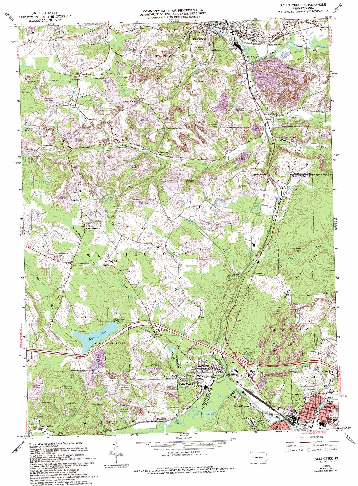
USGS Topo Quad 41078b7 - 1:24,000 scale
| Topo Map Name: | Falls Creek |
| USGS Topo Quad ID: | 41078b7 |
| Print Size: | ca. 21 1/4" wide x 27" high |
| Southeast Coordinates: | 41.125° N latitude / 78.75° W longitude |
| Map Center Coordinates: | 41.1875° N latitude / 78.8125° W longitude |
| U.S. State: | PA |
| Filename: | o41078b7.jpg |
| Download Map JPG Image: | Falls Creek topo map 1:24,000 scale |
| Map Type: | Topographic |
| Topo Series: | 7.5´ |
| Map Scale: | 1:24,000 |
| Source of Map Images: | United States Geological Survey (USGS) |
| Alternate Map Versions: |
Falls Creek PA 1966, updated 1968 Download PDF Buy paper map Falls Creek PA 1966, updated 1973 Download PDF Buy paper map Falls Creek PA 1966, updated 1982 Download PDF Buy paper map Falls Creek PA 1966, updated 1986 Download PDF Buy paper map Falls Creek PA 1966, updated 1994 Download PDF Buy paper map Falls Creek PA 2010 Download PDF Buy paper map Falls Creek PA 2013 Download PDF Buy paper map Falls Creek PA 2016 Download PDF Buy paper map |
1:24,000 Topo Quads surrounding Falls Creek
Marienville East |
Hallton |
Portland Mills |
Ridgway |
Saint Marys |
Sigel |
Munderf |
Carman |
Brandy Camp |
Kersey |
Brookville |
Hazen |
Falls Creek |
Sabula |
Penfield |
Coolspring |
Reynoldsville |
Du Bois |
Luthersburg |
Elliott Park |
Valier |
Punxsutawney |
Mcgees Mills |
Mahaffey |
Curwensville |
> Back to 41078a1 at 1:100,000 scale
> Back to 41078a1 at 1:250,000 scale
> Back to U.S. Topo Maps home
Falls Creek topo map: Gazetteer
Falls Creek: Airports
Bywatler Landing Strip elevation 509m 1669′Falls Creek: Crossings
Interchange 16 elevation 445m 1459′Falls Creek: Lakes
Juniata Lake elevation 430m 1410′Falls Creek: Parks
State Fish Lands elevation 479m 1571′Falls Creek: Populated Places
Adrian Furnace elevation 436m 1430′Beechton elevation 503m 1650′
Beechtree elevation 470m 1541′
Beechwoods elevation 508m 1666′
Brockway elevation 447m 1466′
Clear Run elevation 439m 1440′
Coal Glen elevation 508m 1666′
Crenshaw elevation 451m 1479′
Detwood elevation 445m 1459′
Erie Junction elevation 446m 1463′
Falls Creek elevation 444m 1456′
Harveys Run elevation 464m 1522′
Iselin Heights elevation 482m 1581′
Lanes Mills elevation 448m 1469′
McMinns Summit elevation 481m 1578′
Pancoast elevation 427m 1400′
Red Mill elevation 457m 1499′
Rockdale elevation 490m 1607′
Smith Summit elevation 507m 1663′
Smithtown elevation 486m 1594′
Westville elevation 485m 1591′
Falls Creek: Reservoirs
Kyle Lake elevation 472m 1548′Falls Creek: Streams
Beaver Run elevation 424m 1391′Beaverdam Run elevation 456m 1496′
Clear Run elevation 425m 1394′
Curry Run elevation 440m 1443′
Falls Creek elevation 427m 1400′
Harveys Run elevation 463m 1519′
Kyle Run elevation 472m 1548′
McEwen Run elevation 450m 1476′
Rattlesnake Creek elevation 439m 1440′
Rattlesnake Run elevation 445m 1459′
Slab Run elevation 427m 1400′
Walburn Run elevation 441m 1446′
Wolf Run elevation 469m 1538′
Wolf Run elevation 423m 1387′
Falls Creek digital topo map on disk
Buy this Falls Creek topo map showing relief, roads, GPS coordinates and other geographical features, as a high-resolution digital map file on DVD:
 map DVD")