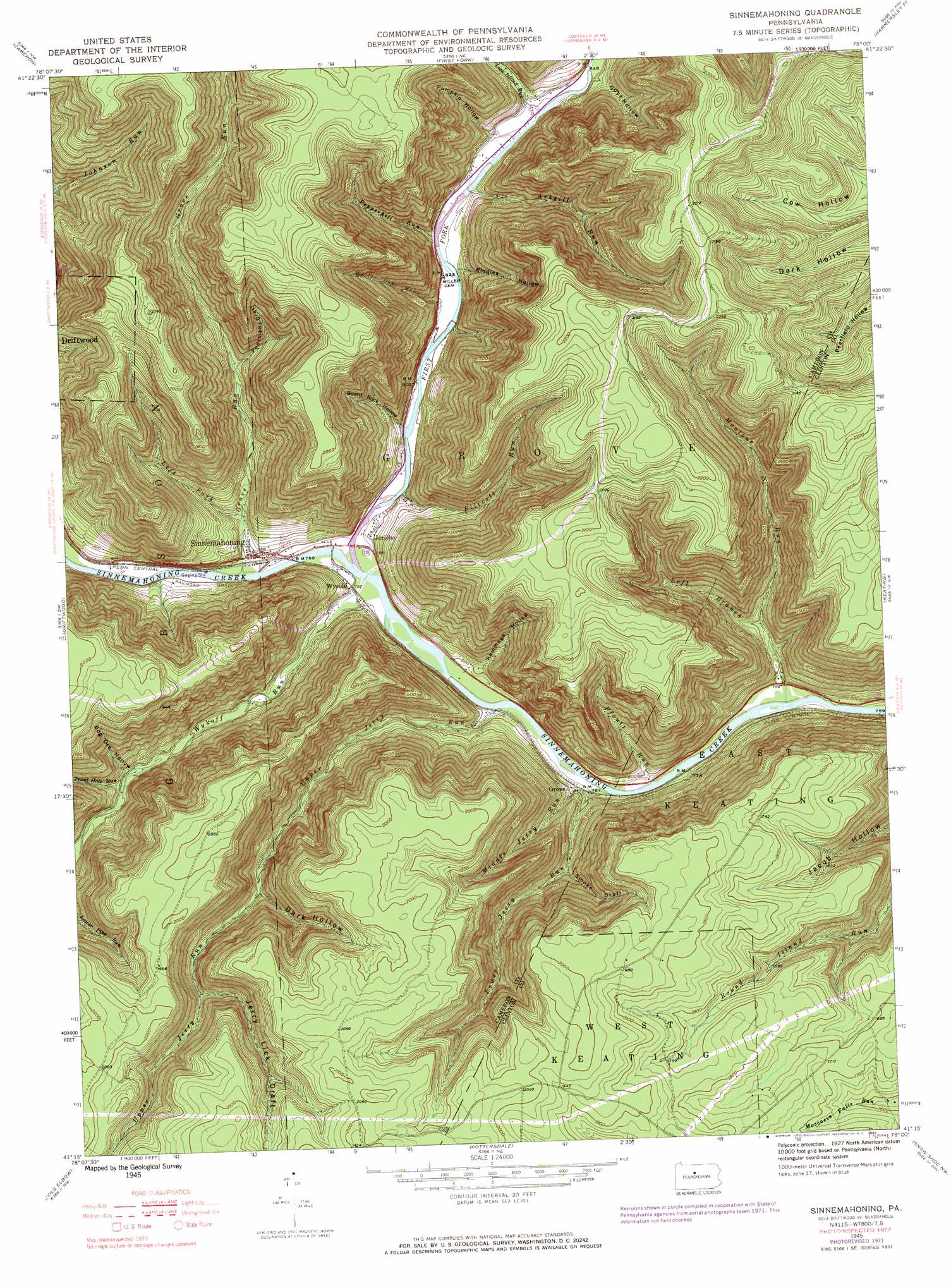
Sinnemahoning Topo Map Pennsylvania
To zoom in, hover over the map of Sinnemahoning
USGS Topo Quad 41078c1 - 1:24,000 scale
| Topo Map Name: | Sinnemahoning |
| USGS Topo Quad ID: | 41078c1 |
| Print Size: | ca. 21 1/4" wide x 27" high |
| Southeast Coordinates: | 41.25° N latitude / 78° W longitude |
| Map Center Coordinates: | 41.3125° N latitude / 78.0625° W longitude |
| U.S. State: | PA |
| Filename: | o41078c1.jpg |
| Download Map JPG Image: | Sinnemahoning topo map 1:24,000 scale |
| Map Type: | Topographic |
| Topo Series: | 7.5´ |
| Map Scale: | 1:24,000 |
| Source of Map Images: | United States Geological Survey (USGS) |
| Alternate Map Versions: |
Sinnemahoning PA 1945, updated 1954 Download PDF Buy paper map Sinnemahoning PA 1945, updated 1972 Download PDF Buy paper map Sinnemahoning PA 1945, updated 1984 Download PDF Buy paper map Sinnemahoning PA 1945, updated 1984 Download PDF Buy paper map Sinnemahoning PA 1945, updated 1984 Download PDF Buy paper map Sinnemahoning PA 1947 Download PDF Buy paper map Sinnemahoning PA 1947 Download PDF Buy paper map Sinnemahoning PA 2010 Download PDF Buy paper map Sinnemahoning PA 2013 Download PDF Buy paper map Sinnemahoning PA 2016 Download PDF Buy paper map |
1:24,000 Topo Quads surrounding Sinnemahoning
Rich Valley |
Emporium |
Wharton |
Conrad |
Short Run |
West Creek |
Cameron |
First Fork |
Hammersley Fork |
Tamarack |
Dents Run |
Driftwood |
Sinnemahoning |
Keating |
Renovo West |
The Knobs |
Devils Elbow |
Pottersdale |
Snow Shoe Nw |
Snow Shoe Ne |
Lecontes Mills |
Frenchville |
Karthaus |
Snow Shoe |
Snow Shoe Se |
> Back to 41078a1 at 1:100,000 scale
> Back to 41078a1 at 1:250,000 scale
> Back to U.S. Topo Maps home
Sinnemahoning topo map: Gazetteer
Sinnemahoning: Areas
Lower Jerry Run Natural Area elevation 413m 1354′Quehanna Wild Area elevation 605m 1984′
Sinnemahoning: Populated Places
Jericho elevation 242m 793′Sinnemahoning elevation 245m 803′
Wyside elevation 238m 780′
Sinnemahoning: Post Offices
Sinnemahoning Post Office (historical) elevation 250m 820′Sinnemahoning: Streams
Arksill Run elevation 272m 892′Ellicott Run elevation 253m 830′
First Fork Sinnemahoning Creek elevation 231m 757′
Grove Run elevation 237m 777′
Left Branch Montour Run elevation 268m 879′
Left Fork Grove Run elevation 252m 826′
Lick Island Run elevation 250m 820′
Lower Jerry Run elevation 232m 761′
Middle Jerry Run elevation 232m 761′
Montour Run elevation 219m 718′
Pepperhill Run elevation 245m 803′
Pfoutz Run elevation 221m 725′
Trout Hole Run elevation 284m 931′
Upper Jerry Run elevation 225m 738′
White Oak Run elevation 238m 780′
White Run elevation 237m 777′
Wykoff Run elevation 231m 757′
Sinnemahoning: Trails
Cut Off Trail elevation 532m 1745′North Fork Trail elevation 500m 1640′
Pepper Hill Trail elevation 638m 2093′
Quehanna Trail elevation 614m 2014′
Round Island Run Trail elevation 418m 1371′
Sinnemahoning: Valleys
Board Rock Hollow elevation 238m 780′Bog Ore Hollow elevation 290m 951′
Dark Hollow elevation 372m 1220′
Guys Hollow elevation 280m 918′
Jerry Lick Draft elevation 427m 1400′
Poormans Draft elevation 339m 1112′
Pumpkin Hollow elevation 258m 846′
Rammage Hollow elevation 250m 820′
Riddles Hollow elevation 281m 921′
Smoke Draft elevation 299m 980′
Sinnemahoning digital topo map on disk
Buy this Sinnemahoning topo map showing relief, roads, GPS coordinates and other geographical features, as a high-resolution digital map file on DVD:
 map DVD")