Ridgway Topo Map Pennsylvania
To zoom in, hover over the map of Ridgway
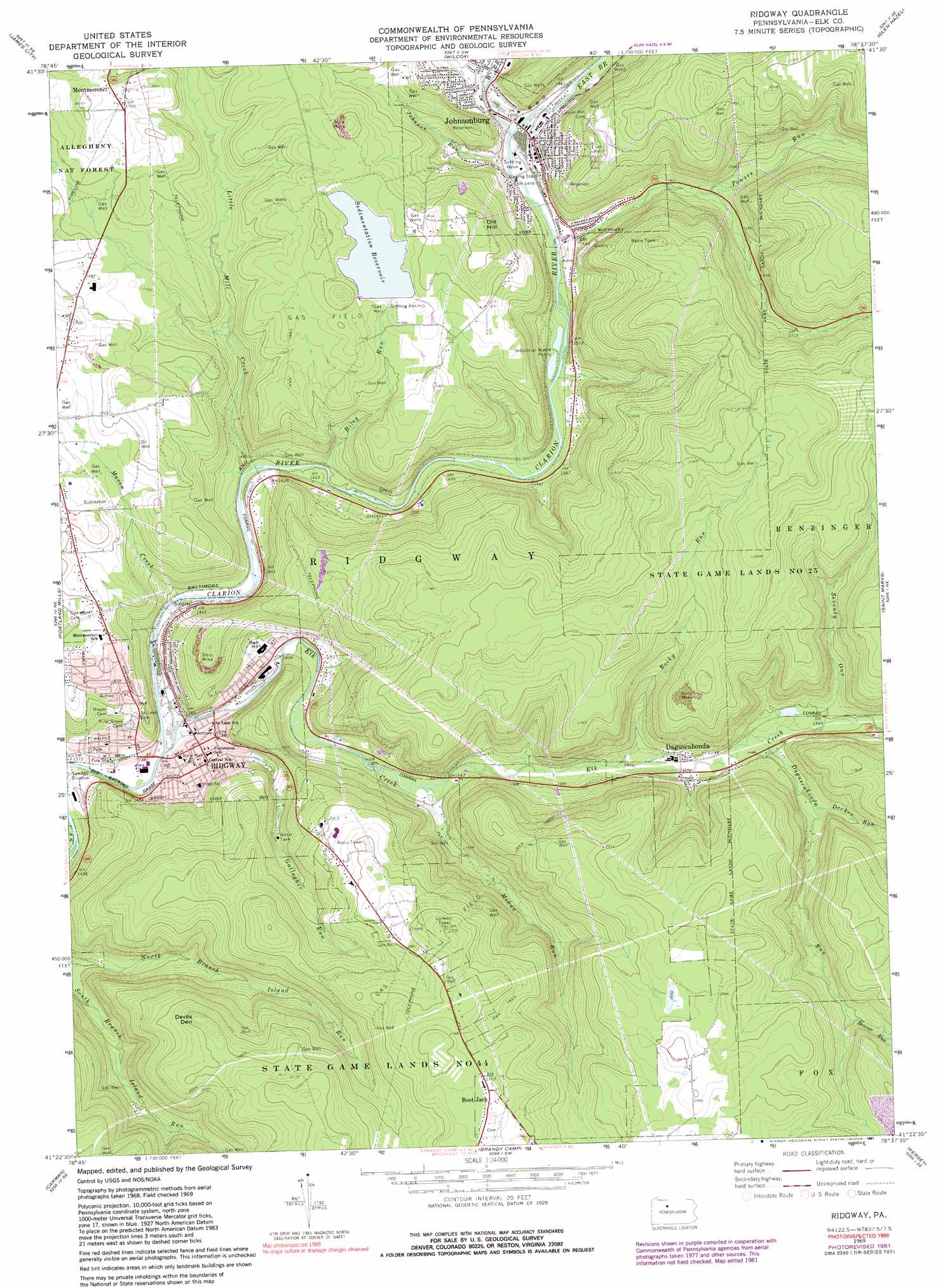
USGS Topo Quad 41078d6 - 1:24,000 scale
| Topo Map Name: | Ridgway |
| USGS Topo Quad ID: | 41078d6 |
| Print Size: | ca. 21 1/4" wide x 27" high |
| Southeast Coordinates: | 41.375° N latitude / 78.625° W longitude |
| Map Center Coordinates: | 41.4375° N latitude / 78.6875° W longitude |
| U.S. State: | PA |
| Filename: | o41078d6.jpg |
| Download Map JPG Image: | Ridgway topo map 1:24,000 scale |
| Map Type: | Topographic |
| Topo Series: | 7.5´ |
| Map Scale: | 1:24,000 |
| Source of Map Images: | United States Geological Survey (USGS) |
| Alternate Map Versions: |
Ridgway PA 1969, updated 1972 Download PDF Buy paper map Ridgway PA 1969, updated 1981 Download PDF Buy paper map Ridgway PA 1969, updated 1991 Download PDF Buy paper map Ridgway PA 2011 Download PDF Buy paper map Ridgway PA 2013 Download PDF Buy paper map Ridgway PA 2016 Download PDF Buy paper map |
| FStopo: | US Forest Service topo Ridgway is available: Download FStopo PDF Download FStopo TIF |
1:24,000 Topo Quads surrounding Ridgway
Ludlow |
Kane |
Mount Jewett |
Hazel Hurst |
Crosby |
Russell City |
James City |
Wilcox |
Glen Hazel |
Wildwood Fire Tower |
Hallton |
Portland Mills |
Ridgway |
Saint Marys |
Rathbun |
Munderf |
Carman |
Brandy Camp |
Kersey |
Weedville |
Hazen |
Falls Creek |
Sabula |
Penfield |
Huntley |
> Back to 41078a1 at 1:100,000 scale
> Back to 41078a1 at 1:250,000 scale
> Back to U.S. Topo Maps home
Ridgway topo map: Gazetteer
Ridgway: Dams
Riley Run Dam elevation 545m 1788′Ridgway: Populated Places
Boot Jack elevation 660m 2165′Daguscahonda elevation 458m 1502′
Johnsonburg elevation 444m 1456′
Montmorenci elevation 531m 1742′
Ridgway elevation 435m 1427′
Rolfe elevation 450m 1476′
Whistletown elevation 435m 1427′
Ridgway: Reservoirs
Bailey Run Reservoir elevation 545m 1788′Sedimentation Reservoir elevation 538m 1765′
Ridgway: Streams
Beaver Run elevation 516m 1692′Daguscahonda Run elevation 449m 1473′
Decker Run elevation 461m 1512′
East Branch Clarion River elevation 439m 1440′
Elk Creek elevation 414m 1358′
Gallagher Run elevation 420m 1377′
Johnson Run elevation 438m 1437′
Little Mill Creek elevation 425m 1394′
Mason Creek elevation 418m 1371′
Mohan Run elevation 436m 1430′
Powers Run elevation 435m 1427′
Riley Run elevation 434m 1423′
Rocky Run elevation 443m 1453′
Seventy One elevation 452m 1482′
Silver Creek elevation 443m 1453′
West Branch Clarion River elevation 439m 1440′
Ridgway: Summits
Devils Den elevation 663m 2175′Dill Hill elevation 589m 1932′
Ridgway digital topo map on disk
Buy this Ridgway topo map showing relief, roads, GPS coordinates and other geographical features, as a high-resolution digital map file on DVD:
 map DVD")