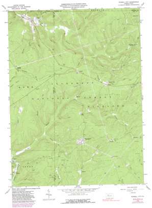
Russell City Topo Map Pennsylvania
To zoom in, hover over the map of Russell City
USGS Topo Quad 41078e8 - 1:24,000 scale
| Topo Map Name: | Russell City |
| USGS Topo Quad ID: | 41078e8 |
| Print Size: | ca. 21 1/4" wide x 27" high |
| Southeast Coordinates: | 41.5° N latitude / 78.875° W longitude |
| Map Center Coordinates: | 41.5625° N latitude / 78.9375° W longitude |
| U.S. State: | PA |
| Filename: | o41078e8.jpg |
| Download Map JPG Image: | Russell City topo map 1:24,000 scale |
| Map Type: | Topographic |
| Topo Series: | 7.5´ |
| Map Scale: | 1:24,000 |
| Source of Map Images: | United States Geological Survey (USGS) |
| Alternate Map Versions: |
Russell City PA 1966, updated 1967 Download PDF Buy paper map Russell City PA 1966, updated 1981 Download PDF Buy paper map Russell City PA 1966, updated 1991 Download PDF Buy paper map Russell City PA 1966, updated 1991 Download PDF Buy paper map Russell City PA 2011 Download PDF Buy paper map Russell City PA 2013 Download PDF Buy paper map Russell City PA 2016 Download PDF Buy paper map |
| FStopo: | US Forest Service topo Russell City is available: Download FStopo PDF Download FStopo TIF |
1:24,000 Topo Quads surrounding Russell City
> Back to 41078e1 at 1:100,000 scale
> Back to 41078a1 at 1:250,000 scale
> Back to U.S. Topo Maps home
Russell City topo map: Gazetteer
Russell City: Populated Places
Brookston elevation 431m 1414′Chaffee elevation 576m 1889′
Corduroy elevation 492m 1614′
Dunring elevation 440m 1443′
Four Corners elevation 567m 1860′
Pigs Ear elevation 485m 1591′
Russell City elevation 583m 1912′
Sackett elevation 582m 1909′
Sheffield Junction elevation 577m 1893′
Threemile elevation 543m 1781′
Windy City elevation 562m 1843′
Russell City: Post Offices
DeYoung Post Office (historical) elevation 583m 1912′Russell City: Reservoirs
Hi-La Fish Rearing Pool elevation 483m 1584′Russell City: Springs
Wolf Run Spring elevation 490m 1607′Russell City: Streams
Bank Run elevation 426m 1397′Bogus Run elevation 426m 1397′
Chaffee Run elevation 455m 1492′
Coon Run elevation 458m 1502′
Crane Run elevation 442m 1450′
East Branch Spring Creek elevation 435m 1427′
East Fork Run elevation 438m 1437′
Eldridge Run elevation 448m 1469′
Fork Run elevation 430m 1410′
Iron Run elevation 434m 1423′
Martin Run elevation 468m 1535′
Pine Run elevation 464m 1522′
Rock Run elevation 425m 1394′
Threemile Run elevation 510m 1673′
Tuttle Run elevation 423m 1387′
Wagner Run elevation 453m 1486′
Warner Run elevation 456m 1496′
West Fork Run elevation 438m 1437′
Wolf Run elevation 468m 1535′
Russell City: Trails
Twin Lakes Trail elevation 523m 1715′Russell City digital topo map on disk
Buy this Russell City topo map showing relief, roads, GPS coordinates and other geographical features, as a high-resolution digital map file on DVD:


