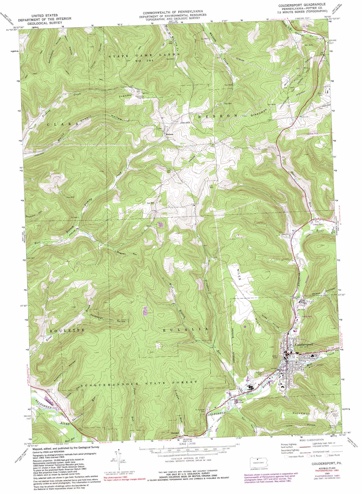
Coudersport Topo Map Pennsylvania
To zoom in, hover over the map of Coudersport
USGS Topo Quad 41078g1 - 1:24,000 scale
| Topo Map Name: | Coudersport |
| USGS Topo Quad ID: | 41078g1 |
| Print Size: | ca. 21 1/4" wide x 27" high |
| Southeast Coordinates: | 41.75° N latitude / 78° W longitude |
| Map Center Coordinates: | 41.8125° N latitude / 78.0625° W longitude |
| U.S. State: | PA |
| Filename: | o41078g1.jpg |
| Download Map JPG Image: | Coudersport topo map 1:24,000 scale |
| Map Type: | Topographic |
| Topo Series: | 7.5´ |
| Map Scale: | 1:24,000 |
| Source of Map Images: | United States Geological Survey (USGS) |
| Alternate Map Versions: |
Coudersport PA 1969, updated 1972 Download PDF Buy paper map Coudersport PA 1969, updated 1981 Download PDF Buy paper map Coudersport PA 1969, updated 1988 Download PDF Buy paper map Coudersport PA 2010 Download PDF Buy paper map Coudersport PA 2013 Download PDF Buy paper map Coudersport PA 2016 Download PDF Buy paper map |
1:24,000 Topo Quads surrounding Coudersport
Portville |
Bolivar |
Allentown |
Wellsville South |
Whitesville |
Bullis Mills |
Shinglehouse |
Oswayo |
Ellisburg |
Ulysses |
Port Allegany |
Roulette |
Coudersport |
Sweden Valley |
Brookland |
Norwich |
Keating Summit |
Austin |
Ayers Hill |
Cherry Springs |
Rich Valley |
Emporium |
Wharton |
Conrad |
Short Run |
> Back to 41078e1 at 1:100,000 scale
> Back to 41078a1 at 1:250,000 scale
> Back to U.S. Topo Maps home
Coudersport topo map: Gazetteer
Coudersport: Airports
Mountain Springs Heliport elevation 566m 1856′Coudersport: Parks
State Game Lands Number 204 elevation 668m 2191′Coudersport: Populated Places
Coudersport elevation 502m 1646′Hebron elevation 639m 2096′
Olmsted elevation 490m 1607′
Coudersport: Streams
Baker Creek elevation 527m 1729′Dingman Run elevation 494m 1620′
Mill Creek elevation 500m 1640′
Reed Run elevation 479m 1571′
Sherwood Run elevation 482m 1581′
Steer Run elevation 521m 1709′
West Branch Dingman Run elevation 524m 1719′
Coudersport: Summits
Crandal Hill elevation 744m 2440′Dutchman Hill elevation 758m 2486′
Greenman Hill elevation 722m 2368′
Negro Hill elevation 730m 2395′
Niles Hill elevation 684m 2244′
Coudersport: Valleys
Castle Hollow elevation 582m 1909′Earl Hollow elevation 499m 1637′
Hogpen Hollow elevation 572m 1876′
Kavanaugh Hollow elevation 533m 1748′
Knowlton Hollow elevation 487m 1597′
Niles Hollow elevation 518m 1699′
Reese Hollow elevation 520m 1706′
Smith Hollow elevation 475m 1558′
Sperl Hollow elevation 547m 1794′
Toles Hollow elevation 526m 1725′
White Hollow elevation 529m 1735′
Coudersport digital topo map on disk
Buy this Coudersport topo map showing relief, roads, GPS coordinates and other geographical features, as a high-resolution digital map file on DVD:
 map DVD")