Cyclone Topo Map Pennsylvania
To zoom in, hover over the map of Cyclone
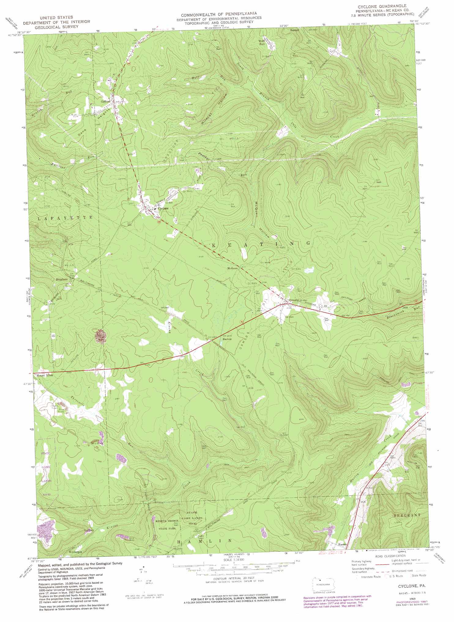
USGS Topo Quad 41078g5 - 1:24,000 scale
| Topo Map Name: | Cyclone |
| USGS Topo Quad ID: | 41078g5 |
| Print Size: | ca. 21 1/4" wide x 27" high |
| Southeast Coordinates: | 41.75° N latitude / 78.5° W longitude |
| Map Center Coordinates: | 41.8125° N latitude / 78.5625° W longitude |
| U.S. State: | PA |
| Filename: | o41078g5.jpg |
| Download Map JPG Image: | Cyclone topo map 1:24,000 scale |
| Map Type: | Topographic |
| Topo Series: | 7.5´ |
| Map Scale: | 1:24,000 |
| Source of Map Images: | United States Geological Survey (USGS) |
| Alternate Map Versions: |
Cyclone PA 1969, updated 1972 Download PDF Buy paper map Cyclone PA 1969, updated 1981 Download PDF Buy paper map Cyclone PA 2010 Download PDF Buy paper map Cyclone PA 2013 Download PDF Buy paper map Cyclone PA 2016 Download PDF Buy paper map |
1:24,000 Topo Quads surrounding Cyclone
Red House |
Limestone |
Knapp Creek |
Olean |
Portville |
Stickney |
Bradford |
Derrick City |
Eldred |
Bullis Mills |
Westline |
Lewis Run |
Cyclone |
Smethport |
Port Allegany |
Kane |
Mount Jewett |
Hazel Hurst |
Crosby |
Norwich |
James City |
Wilcox |
Glen Hazel |
Wildwood Fire Tower |
Rich Valley |
> Back to 41078e1 at 1:100,000 scale
> Back to 41078a1 at 1:250,000 scale
> Back to U.S. Topo Maps home
Cyclone topo map: Gazetteer
Cyclone: Bridges
Kinzua Bridge elevation 545m 1788′Cyclone: Oilfields
Bradford Oil Field elevation 653m 2142′Ormsby Oil Field elevation 645m 2116′
Cyclone: Parks
Kinzua Bridge State Park elevation 651m 2135′Cyclone: Populated Places
Backus elevation 631m 2070′Bingham elevation 641m 2103′
Cyclone elevation 674m 2211′
Gaffney elevation 539m 1768′
Gifford elevation 684m 2244′
McKean elevation 645m 2116′
Ormsby elevation 668m 2191′
Simpson elevation 676m 2217′
Wolf Run elevation 665m 2181′
Cyclone: Post Offices
Cyclone Post Office (historical) elevation 675m 2214′Davis Gifford Post Office (historical) elevation 684m 2244′
Cyclone: Streams
Little Black Brook elevation 615m 2017′Panther Run elevation 493m 1617′
Threemile Run elevation 555m 1820′
Wolf Run elevation 509m 1669′
Cyclone: Summits
Dana Heights elevation 684m 2244′Ormsbys Summit elevation 664m 2178′
Cyclone: Valleys
Kinzua Gorge elevation 545m 1788′McQuen Hollow elevation 542m 1778′
Wildcat Hollow elevation 525m 1722′
Cyclone digital topo map on disk
Buy this Cyclone topo map showing relief, roads, GPS coordinates and other geographical features, as a high-resolution digital map file on DVD:
 map DVD")