Bradford Topo Map Pennsylvania
To zoom in, hover over the map of Bradford
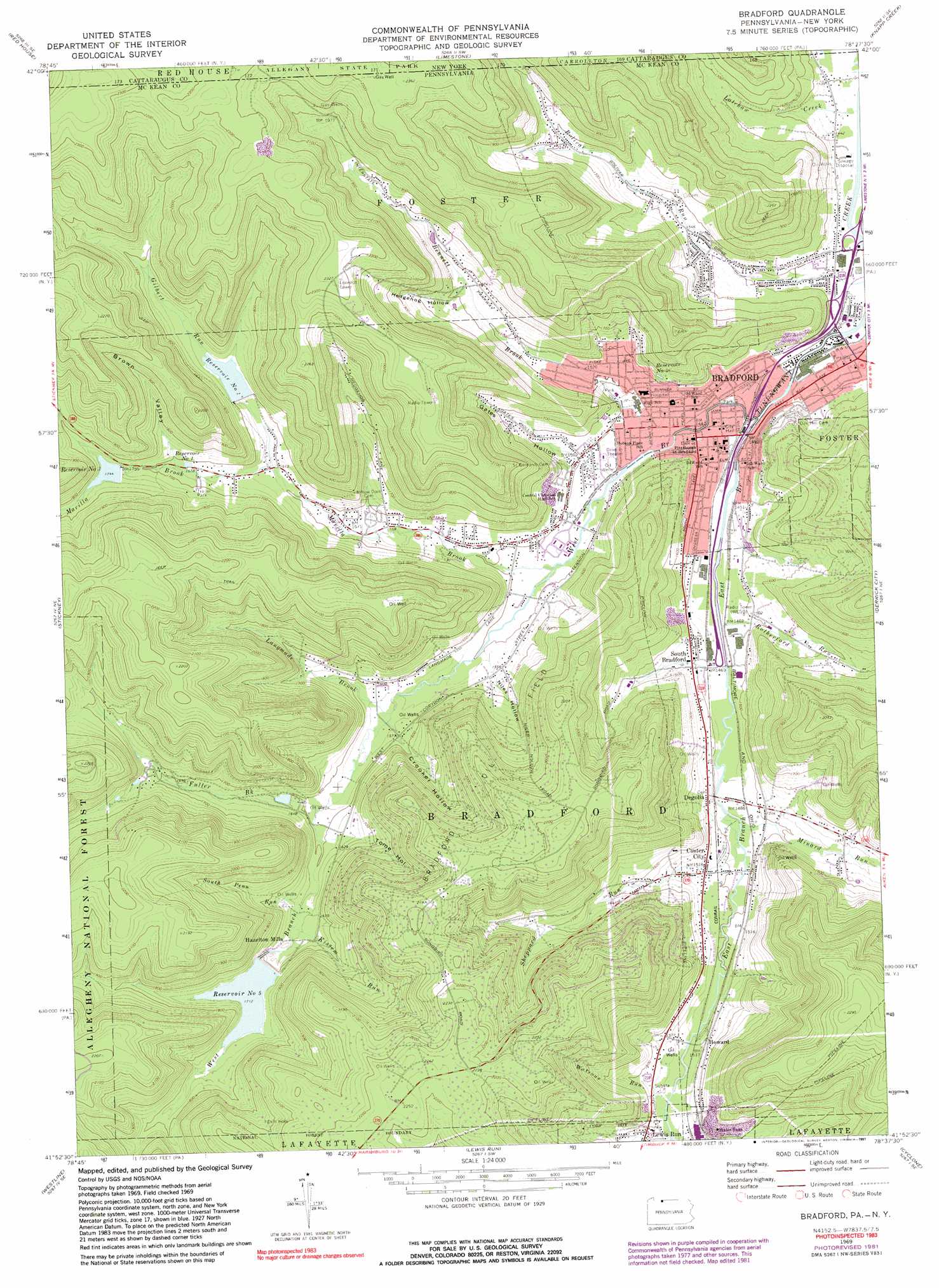
USGS Topo Quad 41078h6 - 1:24,000 scale
| Topo Map Name: | Bradford |
| USGS Topo Quad ID: | 41078h6 |
| Print Size: | ca. 21 1/4" wide x 27" high |
| Southeast Coordinates: | 41.875° N latitude / 78.625° W longitude |
| Map Center Coordinates: | 41.9375° N latitude / 78.6875° W longitude |
| U.S. States: | PA, NY |
| Filename: | o41078h6.jpg |
| Download Map JPG Image: | Bradford topo map 1:24,000 scale |
| Map Type: | Topographic |
| Topo Series: | 7.5´ |
| Map Scale: | 1:24,000 |
| Source of Map Images: | United States Geological Survey (USGS) |
| Alternate Map Versions: |
Bradford PA 1969, updated 1973 Download PDF Buy paper map Bradford PA 1969, updated 1981 Download PDF Buy paper map Bradford PA 1969, updated 1991 Download PDF Buy paper map Bradford PA 2011 Download PDF Buy paper map Bradford PA 2013 Download PDF Buy paper map Bradford PA 2016 Download PDF Buy paper map |
| FStopo: | US Forest Service topo Bradford is available: Download FStopo PDF Download FStopo TIF |
1:24,000 Topo Quads surrounding Bradford
Randolph |
Little Valley |
Salamanca |
Humphrey |
Hinsdale |
Steamburg |
Red House |
Limestone |
Knapp Creek |
Olean |
Cornplanter Run |
Stickney |
Bradford |
Derrick City |
Eldred |
Cornplanter Bridge |
Westline |
Lewis Run |
Cyclone |
Smethport |
Ludlow |
Kane |
Mount Jewett |
Hazel Hurst |
Crosby |
> Back to 41078e1 at 1:100,000 scale
> Back to 41078a1 at 1:250,000 scale
> Back to U.S. Topo Maps home
Bradford topo map: Gazetteer
Bradford: Airports
Miller Airport elevation 660m 2165′Bradford: Dams
Bradford City Number Five Dam elevation 522m 1712′Bradford City Number Three Dam elevation 526m 1725′
Bradford City Number Two Dam elevation 522m 1712′
Bradford: Oilfields
Bradford Oil Field elevation 653m 2142′Bradford: Populated Places
Bradford elevation 439m 1440′Custer City elevation 461m 1512′
Degolia elevation 465m 1525′
Hazelton Mills elevation 515m 1689′
Howard elevation 470m 1541′
South Bradford elevation 459m 1505′
West Bradford elevation 464m 1522′
Bradford: Reservoirs
Bradford City Number Five Reservoir elevation 522m 1712′Bradford City Number Three Reservoir elevation 526m 1725′
Bradford City Number Two Reservoir elevation 522m 1712′
Number Five Reservoir elevation 522m 1712′
Number Four Reservoir elevation 502m 1646′
Number One Reservoir elevation 515m 1689′
Number Three Reservoir elevation 530m 1738′
Number Two Reservoir elevation 520m 1706′
Bradford: Streams
Bennett Brook elevation 442m 1450′East Branch Tunungwant Creek elevation 431m 1414′
Foster Brook elevation 429m 1407′
Foster Run elevation 466m 1528′
Fuller Brook elevation 481m 1578′
Gilbert Run elevation 494m 1620′
Kendall Creek elevation 429m 1407′
Kissem Run elevation 497m 1630′
Langmade Brook elevation 470m 1541′
Latchaw Creek elevation 428m 1404′
Latchaw Creek elevation 428m 1404′
Marilla Brook elevation 448m 1469′
Meadow Brook elevation 469m 1538′
Minard Run elevation 454m 1489′
Rutherford Run elevation 444m 1456′
Sheppard Run elevation 451m 1479′
South Penn Run elevation 494m 1620′
Two Mile Run elevation 541m 1774′
Watrous Run elevation 466m 1528′
West Branch Tunungwant Creek elevation 433m 1420′
Bradford: Summits
Blacksnake Mountain elevation 708m 2322′Bradford: Valleys
Brown Valley elevation 524m 1719′Crooker Hollow elevation 477m 1564′
Gates Hollow elevation 463m 1519′
Hedgehog Hollow elevation 517m 1696′
Niles Hollow elevation 470m 1541′
Tome Hollow elevation 499m 1637′
Bradford digital topo map on disk
Buy this Bradford topo map showing relief, roads, GPS coordinates and other geographical features, as a high-resolution digital map file on DVD:
 map DVD")