Parker Topo Map Pennsylvania
To zoom in, hover over the map of Parker
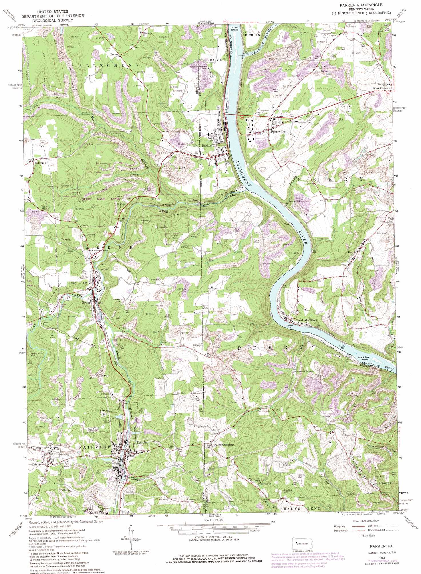
USGS Topo Quad 41079a6 - 1:24,000 scale
| Topo Map Name: | Parker |
| USGS Topo Quad ID: | 41079a6 |
| Print Size: | ca. 21 1/4" wide x 27" high |
| Southeast Coordinates: | 41° N latitude / 79.625° W longitude |
| Map Center Coordinates: | 41.0625° N latitude / 79.6875° W longitude |
| U.S. State: | PA |
| Filename: | o41079a6.jpg |
| Download Map JPG Image: | Parker topo map 1:24,000 scale |
| Map Type: | Topographic |
| Topo Series: | 7.5´ |
| Map Scale: | 1:24,000 |
| Source of Map Images: | United States Geological Survey (USGS) |
| Alternate Map Versions: |
Parker PA 1963, updated 1965 Download PDF Buy paper map Parker PA 1963, updated 1971 Download PDF Buy paper map Parker PA 1963, updated 1973 Download PDF Buy paper map Parker PA 1963, updated 1980 Download PDF Buy paper map Parker PA 1963, updated 1980 Download PDF Buy paper map Parker PA 2010 Download PDF Buy paper map Parker PA 2013 Download PDF Buy paper map Parker PA 2016 Download PDF Buy paper map |
1:24,000 Topo Quads surrounding Parker
Polk |
Kennerdell |
Cranberry |
Kossuth |
Fryburg |
Barkeyville |
Eau Claire |
Emlenton |
Knox |
Clarion |
West Sunbury |
Hilliards |
Parker |
Rimersburg |
Sligo |
Mount Chestnut |
East Butler |
Chicora |
East Brady |
Templeton |
Butler |
Saxonburg |
Worthington |
Kittanning |
Mosgrove |
> Back to 41079a1 at 1:100,000 scale
> Back to 41078a1 at 1:250,000 scale
> Back to U.S. Topo Maps home
Parker topo map: Gazetteer
Parker: Islands
Black Fox Island elevation 256m 839′Clarion Island elevation 263m 862′
Parker: Populated Places
Bonus elevation 446m 1463′Bruin elevation 336m 1102′
Dutch Hill elevation 435m 1427′
Eldorado elevation 437m 1433′
Fairview elevation 427m 1400′
Fredericksburg elevation 393m 1289′
Lawrenceburg elevation 335m 1099′
Millers Eddy elevation 273m 895′
Monterey elevation 265m 869′
Parker elevation 311m 1020′
Parkers Corners elevation 375m 1230′
Perryville elevation 344m 1128′
Petrolia elevation 358m 1174′
Queenstown elevation 344m 1128′
West Monterey elevation 259m 849′
Parker: Post Offices
Baldwin Post Office (historical) elevation 427m 1400′Pollock Post Office (historical) elevation 344m 1128′
Parker: Reservoirs
Number Three Reservoir elevation 375m 1230′Parker: Streams
Bear Creek elevation 260m 853′Black Fox Run elevation 254m 833′
Clarion River elevation 262m 859′
Dunlap Creek elevation 267m 875′
North Branch Bear Creek elevation 293m 961′
Silver Creek elevation 345m 1131′
South Branch Bear Creek elevation 329m 1079′
Thoms Run elevation 262m 859′
Parker: Summits
Columbia Hill elevation 452m 1482′Parker: Valleys
Binker Valley elevation 254m 833′Crozier Hollow elevation 253m 830′
Parker digital topo map on disk
Buy this Parker topo map showing relief, roads, GPS coordinates and other geographical features, as a high-resolution digital map file on DVD:
 map DVD")