Sigel Topo Map Pennsylvania
To zoom in, hover over the map of Sigel
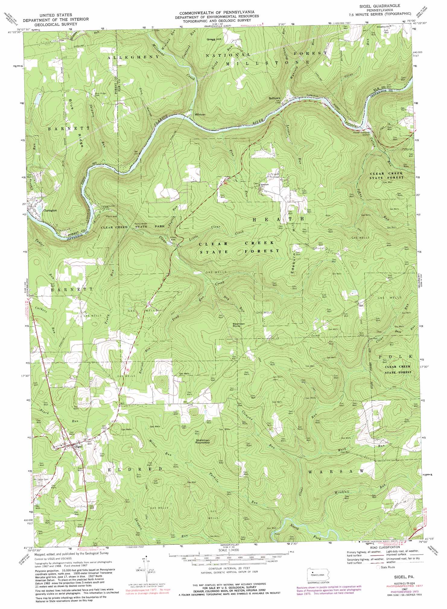
USGS Topo Quad 41079c1 - 1:24,000 scale
| Topo Map Name: | Sigel |
| USGS Topo Quad ID: | 41079c1 |
| Print Size: | ca. 21 1/4" wide x 27" high |
| Southeast Coordinates: | 41.25° N latitude / 79° W longitude |
| Map Center Coordinates: | 41.3125° N latitude / 79.0625° W longitude |
| U.S. State: | PA |
| Filename: | o41079c1.jpg |
| Download Map JPG Image: | Sigel topo map 1:24,000 scale |
| Map Type: | Topographic |
| Topo Series: | 7.5´ |
| Map Scale: | 1:24,000 |
| Source of Map Images: | United States Geological Survey (USGS) |
| Alternate Map Versions: |
Sigel PA 1967, updated 1971 Download PDF Buy paper map Sigel PA 1967, updated 1973 Download PDF Buy paper map Sigel PA 1967, updated 1981 Download PDF Buy paper map Sigel PA 1967, updated 1988 Download PDF Buy paper map Sigel PA 1967, updated 1988 Download PDF Buy paper map Sigel PA 2011 Download PDF Buy paper map Sigel PA 2013 Download PDF Buy paper map Sigel PA 2016 Download PDF Buy paper map |
| FStopo: | US Forest Service topo Sigel is available: Download FStopo PDF Download FStopo TIF |
1:24,000 Topo Quads surrounding Sigel
Kellettville |
Mayburg |
Lynch |
Russell City |
James City |
Tylersburg |
Marienville West |
Marienville East |
Hallton |
Portland Mills |
Lucinda |
Cooksburg |
Sigel |
Munderf |
Carman |
Strattanville |
Corsica |
Brookville |
Hazen |
Falls Creek |
New Bethlehem |
Summerville |
Coolspring |
Reynoldsville |
Du Bois |
> Back to 41079a1 at 1:100,000 scale
> Back to 41078a1 at 1:250,000 scale
> Back to U.S. Topo Maps home
Sigel topo map: Gazetteer
Sigel: Forests
Clear Creek State Forest elevation 551m 1807′Sigel: Parks
Clear Creek State Park elevation 397m 1302′Sigel: Populated Places
Belltown elevation 382m 1253′Clarington elevation 370m 1213′
Millstone elevation 367m 1204′
Sigel elevation 550m 1804′
Sigel: Reservoirs
Truman Pond elevation 535m 1755′Sigel: Ridges
Blue Ridge elevation 491m 1610′Sigel: Streams
Callen Run elevation 377m 1236′Clear Creek elevation 363m 1190′
Clear Run elevation 405m 1328′
Clemens Run elevation 426m 1397′
Cline Run elevation 379m 1243′
Coalbank Run elevation 372m 1220′
Dice Run elevation 507m 1663′
Dry Run elevation 420m 1377′
East Branch Millstone Creek elevation 375m 1230′
English Run elevation 488m 1601′
Gregg Run elevation 390m 1279′
Hoffman Run elevation 404m 1325′
Johns Run elevation 388m 1272′
Leeper Run elevation 374m 1227′
Little Clear Creek elevation 400m 1312′
Miller Run elevation 493m 1617′
Millstone Creek elevation 366m 1200′
Phyllis Run elevation 398m 1305′
Pine Run elevation 365m 1197′
Shippen Run elevation 362m 1187′
Tadler Run elevation 367m 1204′
Tarkiln Run elevation 406m 1332′
Trap Run elevation 415m 1361′
Truby Run elevation 375m 1230′
West Branch Millstone Creek elevation 375m 1230′
Windfall Run elevation 407m 1335′
Winlack Run elevation 374m 1227′
Work Run elevation 432m 1417′
Wyncoop Run elevation 366m 1200′
Sigel: Summits
Beartown Rocks elevation 561m 1840′Edeburn Hill elevation 573m 1879′
Gregg Hill elevation 488m 1601′
Stahlman Roundtop elevation 559m 1833′
Sigel: Trails
Hemlock Trail elevation 497m 1630′Little Clear Creek Trail elevation 513m 1683′
Oak Ridge Trail elevation 480m 1574′
Pine Run Trail elevation 434m 1423′
Silvis Trail elevation 467m 1532′
Wagon Box Trail elevation 459m 1505′
Sigel: Valleys
Dark Hollow elevation 360m 1181′Sigel digital topo map on disk
Buy this Sigel topo map showing relief, roads, GPS coordinates and other geographical features, as a high-resolution digital map file on DVD:
 map DVD")