Corry Topo Map Pennsylvania
To zoom in, hover over the map of Corry
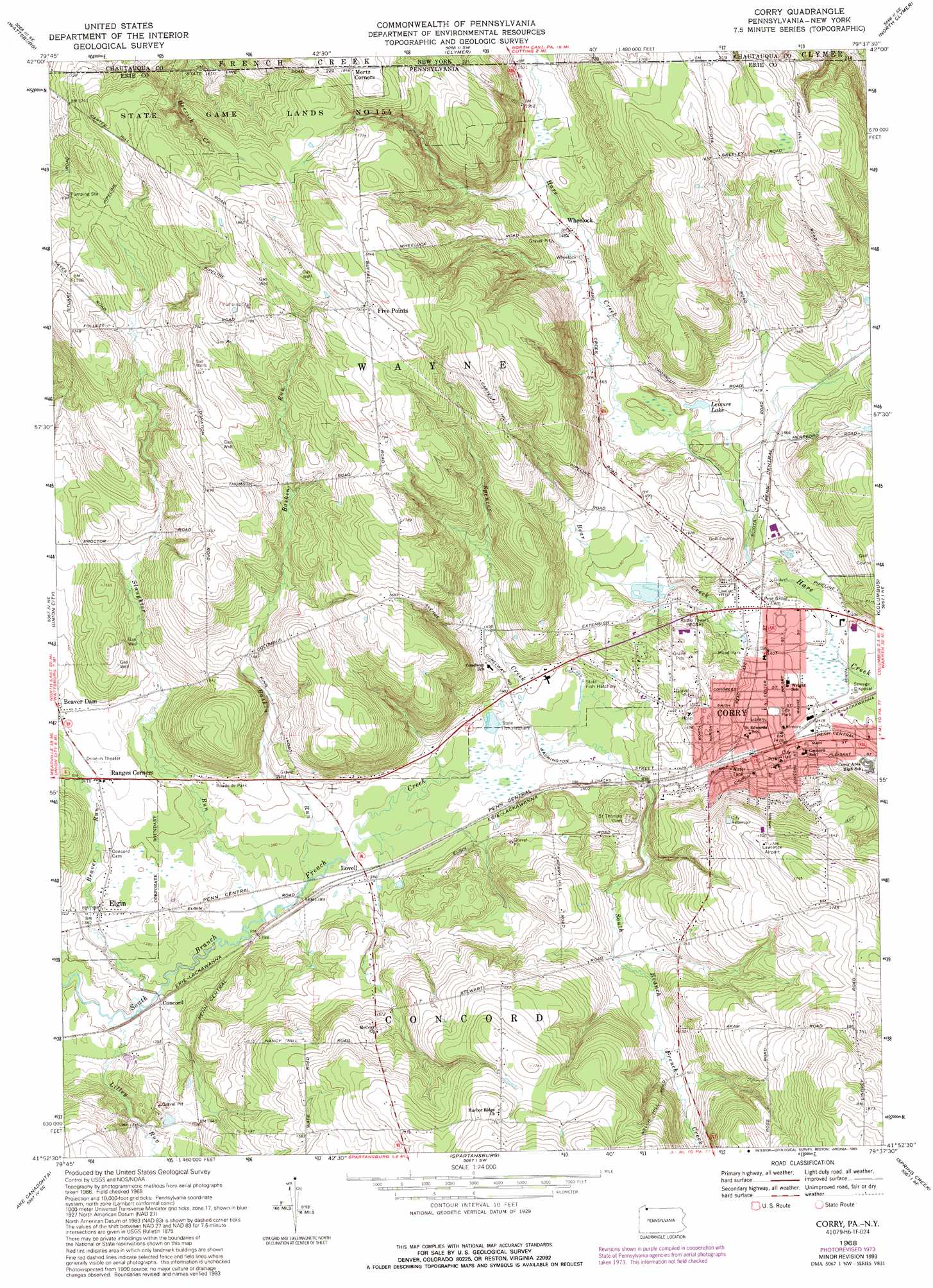
USGS Topo Quad 41079h6 - 1:24,000 scale
| Topo Map Name: | Corry |
| USGS Topo Quad ID: | 41079h6 |
| Print Size: | ca. 21 1/4" wide x 27" high |
| Southeast Coordinates: | 41.875° N latitude / 79.625° W longitude |
| Map Center Coordinates: | 41.9375° N latitude / 79.6875° W longitude |
| U.S. States: | PA, NY |
| Filename: | o41079h6.jpg |
| Download Map JPG Image: | Corry topo map 1:24,000 scale |
| Map Type: | Topographic |
| Topo Series: | 7.5´ |
| Map Scale: | 1:24,000 |
| Source of Map Images: | United States Geological Survey (USGS) |
| Alternate Map Versions: |
Corry PA 1968, updated 1971 Download PDF Buy paper map Corry PA 1968, updated 1975 Download PDF Buy paper map Corry PA 1968, updated 1993 Download PDF Buy paper map Corry PA 2010 Download PDF Buy paper map Corry PA 2013 Download PDF Buy paper map Corry PA 2016 Download PDF Buy paper map |
1:24,000 Topo Quads surrounding Corry
Harborcreek |
North East |
South Ripley |
Sherman |
Chautauqua |
Hammett |
Wattsburg |
Clymer |
North Clymer |
Panama |
Waterford |
Union City |
Corry |
Columbus |
Lottsville |
Millers Station |
Lake Canadohta |
Spartansburg |
Spring Creek |
Pittsfield |
Townville |
Centerville |
Titusville North |
Grand Valley |
Tidioute |
> Back to 41079e1 at 1:100,000 scale
> Back to 41078a1 at 1:250,000 scale
> Back to U.S. Topo Maps home
Corry topo map: Gazetteer
Corry: Airports
Lawrence Airport elevation 527m 1729′Corry: Lakes
Leisure Lake elevation 441m 1446′Corry: Parks
Mead Park elevation 441m 1446′State Game Lands Number 154 elevation 517m 1696′
Corry: Populated Places
Concord elevation 414m 1358′Corry elevation 437m 1433′
Elgin elevation 423m 1387′
Five Points elevation 561m 1840′
Lovell elevation 422m 1384′
Ranges Corners elevation 433m 1420′
Wheelock elevation 451m 1479′
Corry: Streams
Baskin Run elevation 417m 1368′Bear Creek elevation 423m 1387′
Beaver Run elevation 411m 1348′
Lilley Run elevation 411m 1348′
Slaughter Run elevation 413m 1354′
Spencer Creek elevation 419m 1374′
Corry digital topo map on disk
Buy this Corry topo map showing relief, roads, GPS coordinates and other geographical features, as a high-resolution digital map file on DVD:
 map DVD")