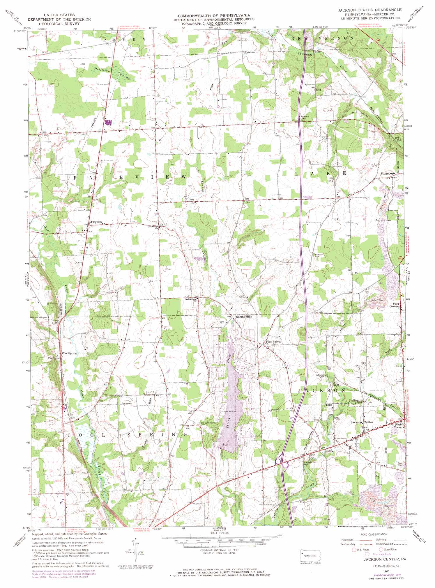
Jackson Center Topo Map Pennsylvania
To zoom in, hover over the map of Jackson Center
USGS Topo Quad 41080c2 - 1:24,000 scale
| Topo Map Name: | Jackson Center |
| USGS Topo Quad ID: | 41080c2 |
| Print Size: | ca. 21 1/4" wide x 27" high |
| Southeast Coordinates: | 41.25° N latitude / 80.125° W longitude |
| Map Center Coordinates: | 41.3125° N latitude / 80.1875° W longitude |
| U.S. State: | PA |
| Filename: | o41080c2.jpg |
| Download Map JPG Image: | Jackson Center topo map 1:24,000 scale |
| Map Type: | Topographic |
| Topo Series: | 7.5´ |
| Map Scale: | 1:24,000 |
| Source of Map Images: | United States Geological Survey (USGS) |
| Alternate Map Versions: |
Jackson Center PA 1960, updated 1961 Download PDF Buy paper map Jackson Center PA 1960, updated 1972 Download PDF Buy paper map Jackson Center PA 1960, updated 1972 Download PDF Buy paper map Jackson Center PA 2010 Download PDF Buy paper map Jackson Center PA 2013 Download PDF Buy paper map Jackson Center PA 2016 Download PDF Buy paper map |
1:24,000 Topo Quads surrounding Jackson Center
Hartstown |
Conneaut Lake |
Geneva |
Cochranton |
Sugar Lake |
Greenville West |
Greenville East |
Hadley |
New Lebanon |
Utica |
Sharpsville |
Fredonia |
Jackson Center |
Sandy Lake |
Polk |
Sharon East |
Greenfield |
Mercer |
Grove City |
Barkeyville |
Edinburg |
New Castle North |
Harlansburg |
Slippery Rock |
West Sunbury |
> Back to 41080a1 at 1:100,000 scale
> Back to 41080a1 at 1:250,000 scale
> Back to U.S. Topo Maps home
Jackson Center topo map: Gazetteer
Jackson Center: Dams
Lake Latonka Dam elevation 360m 1181′Jackson Center: Parks
State Game Lands Number 294 elevation 368m 1207′Jackson Center: Populated Places
Cool Spring elevation 349m 1145′Fairview elevation 394m 1292′
Filer Corners elevation 422m 1384′
Five Points elevation 391m 1282′
Jackson Center elevation 402m 1318′
Nesbit Corners elevation 393m 1289′
North Mills elevation 368m 1207′
Jackson Center: Reservoirs
Lake Latonka elevation 360m 1181′Jackson Center: Streams
Fox Run elevation 397m 1302′Kents Run elevation 338m 1108′
Mill Run elevation 342m 1122′
Jackson Center: Swamps
Halfmoon Swamp elevation 425m 1394′Jackson Center digital topo map on disk
Buy this Jackson Center topo map showing relief, roads, GPS coordinates and other geographical features, as a high-resolution digital map file on DVD:
 map DVD")