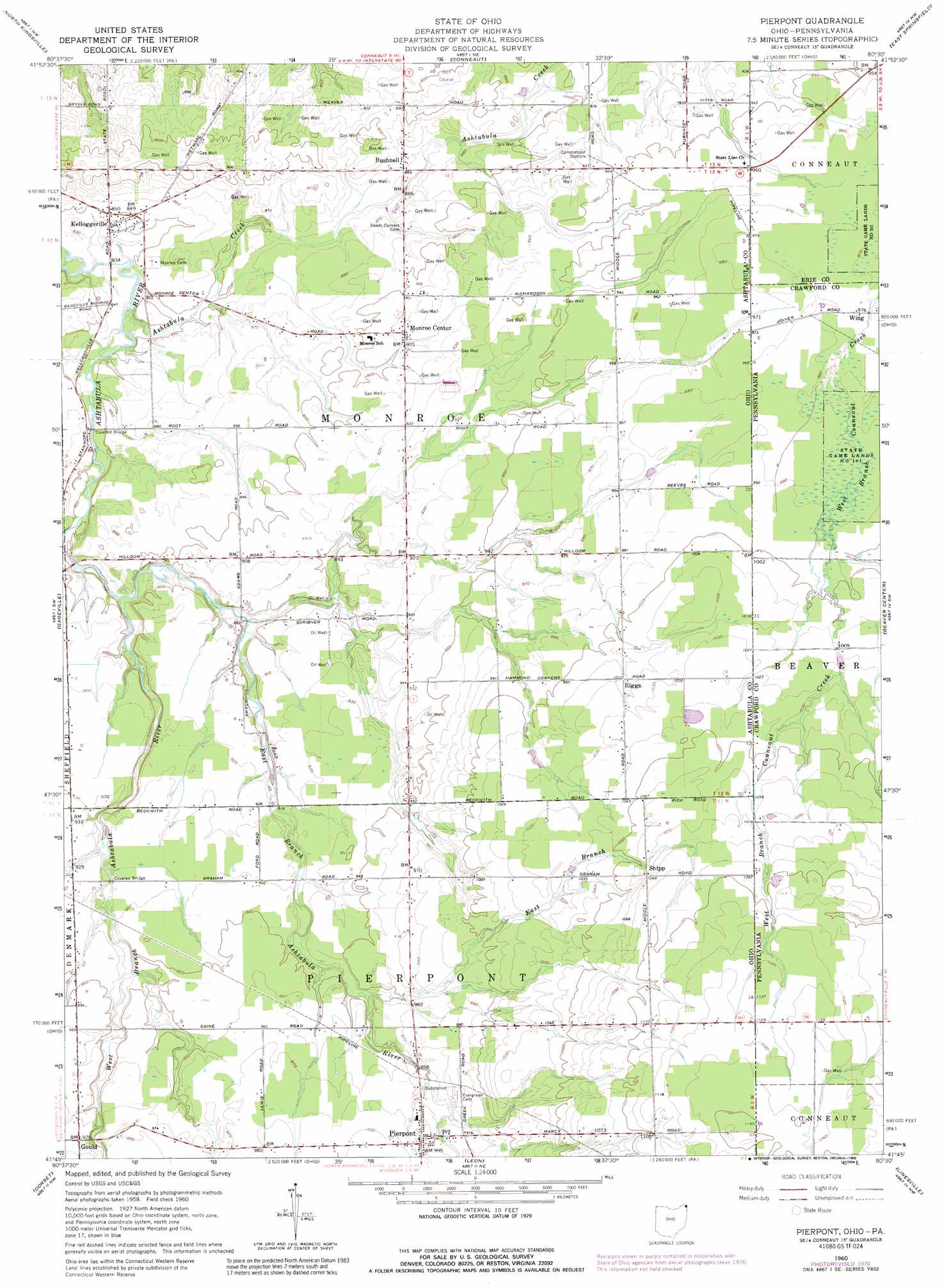
Pierpont Topo Map Ohio
To zoom in, hover over the map of Pierpont
USGS Topo Quad 41080g5 - 1:24,000 scale
| Topo Map Name: | Pierpont |
| USGS Topo Quad ID: | 41080g5 |
| Print Size: | ca. 21 1/4" wide x 27" high |
| Southeast Coordinates: | 41.75° N latitude / 80.5° W longitude |
| Map Center Coordinates: | 41.8125° N latitude / 80.5625° W longitude |
| U.S. States: | OH, PA |
| Filename: | o41080g5.jpg |
| Download Map JPG Image: | Pierpont topo map 1:24,000 scale |
| Map Type: | Topographic |
| Topo Series: | 7.5´ |
| Map Scale: | 1:24,000 |
| Source of Map Images: | United States Geological Survey (USGS) |
| Alternate Map Versions: |
Pierpont OH 1960, updated 1961 Download PDF Buy paper map Pierpont OH 1960, updated 1970 Download PDF Buy paper map Pierpont OH 1960, updated 1971 Download PDF Buy paper map Pierpont OH 1960, updated 1989 Download PDF Buy paper map Pierpont OH 1994, updated 1997 Download PDF Buy paper map Pierpont OH 2010 Download PDF Buy paper map Pierpont OH 2013 Download PDF Buy paper map Pierpont OH 2016 Download PDF Buy paper map |
1:24,000 Topo Quads surrounding Pierpont
Fairview Sw |
Fairview |
|||
Ashtabula North |
North Kingsville |
Conneaut |
East Springfield |
Albion |
Ashtabula South |
Gageville |
Pierpont |
Beaver Center |
Conneautville |
Jefferson |
Dorset |
Leon |
Linesville |
Harmonsburg |
Orwell |
Cherry Valley |
Andover |
Hartstown |
Conneaut Lake |
> Back to 41080e1 at 1:100,000 scale
> Back to 41080a1 at 1:250,000 scale
> Back to U.S. Topo Maps home
Pierpont topo map: Gazetteer
Pierpont: Airports
Murtha Airport elevation 291m 954′Pierpont: Bridges
Caine Road Bridge elevation 283m 928′Graham Road Bridge elevation 277m 908′
Root Road Bridge elevation 256m 839′
Pierpont: Populated Places
Bushnell elevation 264m 866′Kelloggsville elevation 259m 849′
Monroe Center elevation 278m 912′
Riggs elevation 308m 1010′
Shipp elevation 325m 1066′
Pierpont: Post Offices
Kellogsville Post Office (historical) elevation 256m 839′Monroe Center Post Office (historical) elevation 278m 912′
Riggs Post Office (historical) elevation 309m 1013′
Ship Post Office (historical) elevation 324m 1062′
Unionville Post Office elevation 335m 1099′
Pierpont: Streams
Ashtabula Creek elevation 254m 833′Ashtabula Creek elevation 254m 833′
East Branch elevation 286m 938′
East Branch Ashtabula River elevation 260m 853′
West Branch Ashtabula River elevation 261m 856′
Pierpont digital topo map on disk
Buy this Pierpont topo map showing relief, roads, GPS coordinates and other geographical features, as a high-resolution digital map file on DVD:
 map DVD")