North Kingsville Topo Map Ohio
To zoom in, hover over the map of North Kingsville
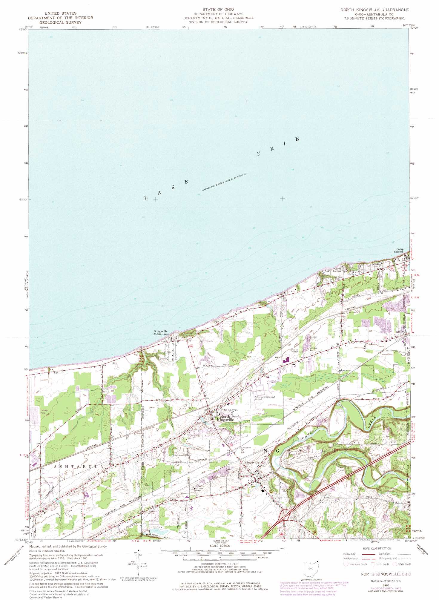
USGS Topo Quad 41080h6 - 1:24,000 scale
| Topo Map Name: | North Kingsville |
| USGS Topo Quad ID: | 41080h6 |
| Print Size: | ca. 21 1/4" wide x 27" high |
| Southeast Coordinates: | 41.875° N latitude / 80.625° W longitude |
| Map Center Coordinates: | 41.9375° N latitude / 80.6875° W longitude |
| U.S. State: | OH |
| Filename: | o41080h6.jpg |
| Download Map JPG Image: | North Kingsville topo map 1:24,000 scale |
| Map Type: | Topographic |
| Topo Series: | 7.5´ |
| Map Scale: | 1:24,000 |
| Source of Map Images: | United States Geological Survey (USGS) |
| Alternate Map Versions: |
North Kingsville OH 1960, updated 1961 Download PDF Buy paper map North Kingsville OH 1960, updated 1971 Download PDF Buy paper map North Kingsville OH 1960, updated 1980 Download PDF Buy paper map North Kingsville OH 1994, updated 1997 Download PDF Buy paper map North Kingsville OH 2010 Download PDF Buy paper map North Kingsville OH 2013 Download PDF Buy paper map North Kingsville OH 2016 Download PDF Buy paper map |
1:24,000 Topo Quads surrounding North Kingsville
Fairview Sw |
||||
Ashtabula North |
North Kingsville |
Conneaut |
East Springfield |
|
Geneva |
Ashtabula South |
Gageville |
Pierpont |
Beaver Center |
East Trumbull |
Jefferson |
Dorset |
Leon |
Linesville |
> Back to 41080e1 at 1:100,000 scale
> Back to 41080a1 at 1:250,000 scale
> Back to U.S. Topo Maps home
North Kingsville topo map: Gazetteer
North Kingsville: Airports
Ashtabula-Conneaut Airport elevation 218m 715′North Kingsville: Crossings
Interchange 235 elevation 239m 784′North Kingsville: Dams
Ashtabula County Outdoor Club Lake Dam elevation 230m 754′Davis Pond Dam elevation 247m 810′
Effluent Treatment Pond Number Four Dam elevation 194m 636′
North Kingsville: Parks
Sunset Park elevation 192m 629′Village Green Park elevation 199m 652′
North Kingsville: Populated Places
Camp Calvary elevation 192m 629′Camp Luther elevation 196m 643′
Kingsville elevation 240m 787′
Kingsville On-the-Lake elevation 193m 633′
Mobile Acres elevation 201m 659′
North Kingsville elevation 217m 711′
Taylor Mobile Home Park elevation 210m 688′
North Kingsville: Post Offices
Kingsville Post Office elevation 236m 774′North Kingsville Post Office elevation 216m 708′
North Kingsville: Reservoirs
Ashtabula County Outdoor Club Lake elevation 230m 754′Davis Pond elevation 247m 810′
Effluent Treatment Pond Number Four elevation 194m 636′
North Kingsville digital topo map on disk
Buy this North Kingsville topo map showing relief, roads, GPS coordinates and other geographical features, as a high-resolution digital map file on DVD:
 map DVD")