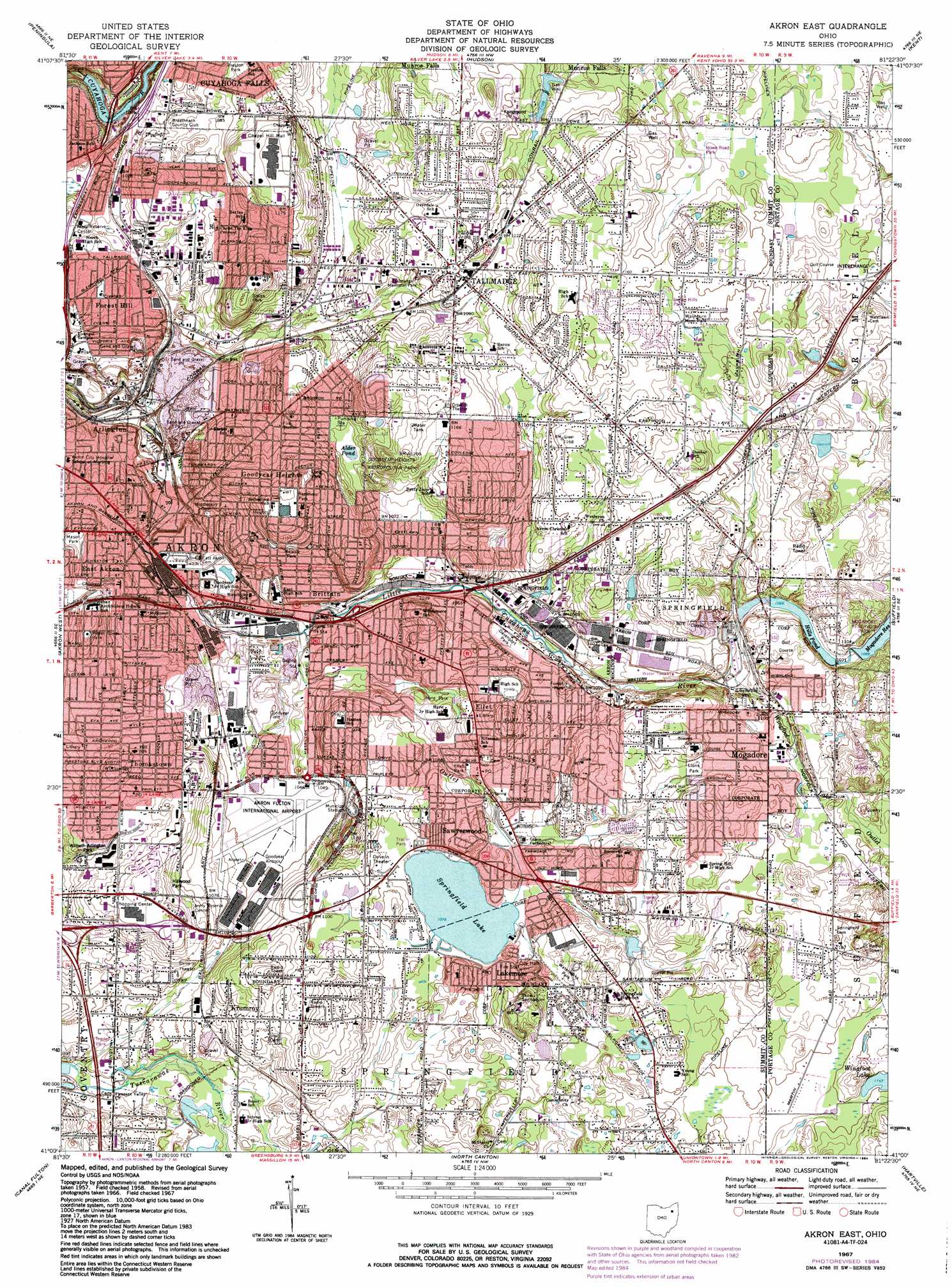
Akron East Topo Map Ohio
To zoom in, hover over the map of Akron East
USGS Topo Quad 41081a4 - 1:24,000 scale
| Topo Map Name: | Akron East |
| USGS Topo Quad ID: | 41081a4 |
| Print Size: | ca. 21 1/4" wide x 27" high |
| Southeast Coordinates: | 41° N latitude / 81.375° W longitude |
| Map Center Coordinates: | 41.0625° N latitude / 81.4375° W longitude |
| U.S. State: | OH |
| Filename: | o41081a4.jpg |
| Download Map JPG Image: | Akron East topo map 1:24,000 scale |
| Map Type: | Topographic |
| Topo Series: | 7.5´ |
| Map Scale: | 1:24,000 |
| Source of Map Images: | United States Geological Survey (USGS) |
| Alternate Map Versions: |
Akron East OH 1958, updated 1959 Download PDF Buy paper map Akron East OH 1967, updated 1969 Download PDF Buy paper map Akron East OH 1967, updated 1980 Download PDF Buy paper map Akron East OH 1967, updated 1984 Download PDF Buy paper map Akron East OH 1967, updated 1984 Download PDF Buy paper map Akron East OH 1994, updated 1997 Download PDF Buy paper map Akron East OH 2010 Download PDF Buy paper map Akron East OH 2013 Download PDF Buy paper map Akron East OH 2016 Download PDF Buy paper map |
1:24,000 Topo Quads surrounding Akron East
Broadview Heights |
Northfield |
Twinsburg |
Aurora |
Mantua |
West Richfield |
Peninsula |
Hudson |
Kent |
Ravenna |
Wadsworth |
Akron West |
Akron East |
Suffield |
Atwater |
Doylestown |
Canal Fulton |
North Canton |
Hartville |
Limaville |
Dalton |
Massillon |
Canton West |
Canton East |
Robertsville |
> Back to 41081a1 at 1:100,000 scale
> Back to 41080a1 at 1:250,000 scale
> Back to U.S. Topo Maps home
Akron East topo map: Gazetteer
Akron East: Airports
Akron Fulton International Airport elevation 315m 1033′Akron East: Crossings
Interchange 26 elevation 315m 1033′Interchange 29 elevation 353m 1158′
Interchange 31 elevation 336m 1102′
Akron East: Dams
Carter Lake Dam elevation 336m 1102′Gorge Metropolitan Park Dam elevation 256m 839′
Hills Pond Dam elevation 323m 1059′
Mogadore Dam elevation 325m 1066′
Akron East: Lakes
Blue Pond elevation 307m 1007′Springfield Lake elevation 328m 1076′
Akron East: Parks
Airport Park elevation 324m 1062′Bettes Park elevation 332m 1089′
Davenport Park elevation 324m 1062′
Ellet Park elevation 328m 1076′
Goodyear Field elevation 319m 1046′
Goodyear Heights Metropolitan Park elevation 363m 1190′
Hillwood Park elevation 352m 1154′
Howe Road Park elevation 341m 1118′
Hyre Park elevation 319m 1046′
Indian Hills Park elevation 347m 1138′
Lakemore Recreation Park elevation 330m 1082′
Lions Club Park elevation 351m 1151′
Lions Park elevation 345m 1131′
Long Park elevation 359m 1177′
Maca Park elevation 347m 1138′
Malasia Park elevation 341m 1118′
Mason Park elevation 327m 1072′
Mogadore Reservoir Park elevation 349m 1145′
Municipal Stadium elevation 332m 1089′
Preston Park elevation 340m 1115′
Reservoir Park elevation 357m 1171′
Seiberling Field elevation 307m 1007′
Tallmadge Town Square Historic District elevation 340m 1115′
Water Tower Park elevation 357m 1171′
Waterworks Park elevation 338m 1108′
Wilbeth Arlington Park elevation 331m 1085′
Akron East: Populated Places
Arlington elevation 311m 1020′Bear's Mobile Home Park elevation 329m 1079′
Bettes Corners elevation 308m 1010′
Boal's Trailer Park elevation 349m 1145′
Brittain elevation 325m 1066′
Coventry Estates elevation 314m 1030′
Derby Downs elevation 338m 1108′
East Akron elevation 306m 1003′
Ellet elevation 342m 1122′
Ellet Heights Mobile Home Park elevation 340m 1115′
Forest Hill elevation 316m 1036′
Frank's Mobile Home Park elevation 329m 1079′
Gaslight Village Mobile Home Park elevation 325m 1066′
Goodyear Heights elevation 344m 1128′
Highland Mobile Home Park elevation 338m 1108′
Krumroy elevation 339m 1112′
Lakemore elevation 331m 1085′
Logtown elevation 364m 1194′
Mogadore elevation 350m 1148′
North Springfield elevation 337m 1105′
Plaza Trailer Court elevation 342m 1122′
Pony elevation 361m 1184′
Sawyerwood elevation 335m 1099′
Six Corners elevation 361m 1184′
Tallmadge elevation 340m 1115′
The Willows elevation 338m 1108′
Thomastown elevation 344m 1128′
Trailer Village elevation 320m 1049′
White House Park elevation 341m 1118′
Akron East: Post Offices
Brittain Post Office (historical) elevation 325m 1066′Ellet Post Office elevation 329m 1079′
Ellet Post Office (historical) elevation 341m 1118′
Krumroy Post Office (historical) elevation 337m 1105′
Lakemore Post Office elevation 330m 1082′
Lakemore Post Office elevation 332m 1089′
Mogadore Post Office elevation 350m 1148′
Sawyerwood Post Office (historical) elevation 335m 1099′
Tallmadge Post Office elevation 340m 1115′
Thomastown Post Office (historical) elevation 345m 1131′
Akron East: Reservoirs
Alder Pond elevation 323m 1059′Carter Lake elevation 336m 1102′
Cuyahoga River Reservoir elevation 256m 839′
Hills Pond elevation 323m 1059′
Hills Pond elevation 323m 1059′
Mogadore Reservoir elevation 325m 1066′
Akron East: Streams
Springfield Lake Outlet elevation 307m 1007′Wingfoot Lake Outlet elevation 320m 1049′
Akron East: Summits
Coal Hill elevation 366m 1200′Akron East digital topo map on disk
Buy this Akron East topo map showing relief, roads, GPS coordinates and other geographical features, as a high-resolution digital map file on DVD:
 map DVD")